Sorico
| Sorico | ||
|---|---|---|
| Comune | ||
| Comune di Sorico | ||
| ||
 Sorico Location of Sorico in Italy | ||
| Coordinates: 46°10′N 9°23′E / 46.167°N 9.383°ECoordinates: 46°10′N 9°23′E / 46.167°N 9.383°E | ||
| Country | Italy | |
| Region | Lombardy | |
| Province / Metropolitan city | Province of Como (CO) | |
| Frazioni | Albonico, Bugiallo, Dascio | |
| Area | ||
| • Total | 23.3 km2 (9.0 sq mi) | |
| Population (Dec. 2004) | ||
| • Total | 1,188 | |
| • Density | 51/km2 (130/sq mi) | |
| Time zone | CET (UTC+1) | |
| • Summer (DST) | CEST (UTC+2) | |
| Postal code | 22010 | |
| Dialing code | 0344 | |
| Website | Official website | |

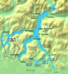
Sorico is a comune (municipality) in the Province of Como in the Italian region Lombardy, located about 80 kilometres (50 mi) north of Milan and about 45 kilometres (28 mi) northeast of Como. As of 31 December 2004, it had a population of 1,188 and an area of 23.3 square kilometres (9.0 sq mi).[1]
The municipality of Sorico contains the frazioni (subdivisions, mainly villages and hamlets) Albonico, Bugiallo, and Dascio.
Sorico borders the following municipalities: Dubino, Gera Lario, Montemezzo, Novate Mezzola, Samolaco, Verceia.
Demographic evolution

Transport and Tourism
Sorico is a stopping point on the bus service that links Como to Colico via the west side of Lake Como. It is the northern endpoint of the long-distance footpath, La Via dei Monti Lariani.
References
External links
| Wikimedia Commons has media related to Sorico. |
| Settlements |
|  |
|---|---|---|
| Islands | ||
| Rivers | ||
| Valleys | ||
| Mountains | ||
| Landmarks | ||
| Films | ||
| People | ||
This article is issued from Wikipedia - version of the 8/5/2014. The text is available under the Creative Commons Attribution/Share Alike but additional terms may apply for the media files.