Cernobbio
| Cernobbio | |
|---|---|
| Comune | |
| Città di Cernobbio | |
|
Panorama of Cernobbio | |
 Cernobbio Location of Cernobbio in Italy | |
| Coordinates: 45°50′N 9°4′E / 45.833°N 9.067°ECoordinates: 45°50′N 9°4′E / 45.833°N 9.067°E | |
| Country | Italy |
| Region | Lombardy |
| Province / Metropolitan city | Province of Como (CO) |
| Frazioni | Piazza Santo Stefano, Rovenna, Casnedo, Gentrino, Madrona, Mornello, Olzino, Stimianico, Toldino |
| Government | |
| • Mayor | Paolo Furgoni |
| Area | |
| • Total | 11.7 km2 (4.5 sq mi) |
| Elevation | 202 m (663 ft) |
| Population (31 December 2010)[1] | |
| • Total | 7,059 |
| • Density | 600/km2 (1,600/sq mi) |
| Demonym(s) | Cernobbiesi |
| Time zone | CET (UTC+1) |
| • Summer (DST) | CEST (UTC+2) |
| Postal code | 22012 |
| Dialing code | 031 |
| Website | Official website |

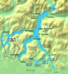
Cernobbio is a comune (municipality) in the province of Como, Lombardy, northern Italy. It is located about 40 kilometres (25 mi) north of Milan and about 2 kilometres (1 mi) northwest of Como, on the border with Switzerland and near the Lake Como. The highest peak is the Monte Bisbino, at 1,325 m.
Cernobbio borders the following municipalities: Blevio, Breggia (Switzerland), Como, Maslianico, Moltrasio, Vacallo (Switzerland).
Cernobbio received the honorary title of city with a presidential decree on May 24, 2005.
Events
Since 1975, every year in early September the city of Cernobbio hosts the Ambrosetti Forum, an international economic conference.
Transport and Tourism
Cernobbio is a stopping point on the bus and ferry services that link Como to Colico via the west side of Lake Como. It is the starting point for the long-distance footpath, La Via dei Monti Lariani.
See also
References
External links
| Settlements |
|  |
|---|---|---|
| Islands | ||
| Rivers | ||
| Valleys | ||
| Mountains | ||
| Landmarks | ||
| Films | ||
| People | ||