Sind Valley
Coordinates: 34°17′21″N 74°48′45″E / 34.28917°N 74.81250°E
| Sind Valley | |
| Valley | |
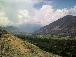 The Sind Valley at Wayil | |
| Country | India |
|---|---|
| State | Jammu and Kashmir |
| Region | Kashmir Division |
| District | Ganderbal |
| Municipality | Kangan |
| Borders on | Zojila (East) Kashmir Valley (West) |
| River | Sind River |
| Highest point | |
| - location | Baltal |
| - elevation | 9,364 ft (2,854 m) |
| - coordinates | 34°15′22″N 75°25′8″E / 34.25611°N 75.41889°E |
| Lowest point | |
| - location | Wayil |
| - elevation | 5,505 ft (1,678 m) |
| - coordinates | 34°17′21″N 74°48′45″E / 34.28917°N 74.81250°E |
| Length | 40 mi (64 km) |
| Width | 0.6 mi (1 km) |
| Population | 97,874[1] (2001) |
| Easiest access | NH 1D |
The Sind Valley is a Himalayan sub-valley of the Kashmir Valley in the State of Jammu and Kashmir of India. The entrance of the Sind Valley lies 33 kilometres (21 mi) northeast of Srinagar the capital of Jammu and Kashmir. It is a 65 kilometres (40 mi) long gorge valley[2] with an average width of 1 kilometre (0.62 mi).
History
The Sind Valley had a strategic importance on the ancient Silk Road. It worked as a bridge between India, China and Central Asia along with Srinagar-Skardu Route.[3] First Hinduism[4] and then Islam spread in Kashmir through this route. This route was also taken by a Persian saint Shah Hamdan to enter the Kashmir Valley in 1372 along with his 700 followers (Syeds)[5] who introduced different types of artistic works in the valley.[6] The Sind Valley still connects Ladakh with the rest of India through a National Highway NH 1D, though it remains closed during winter due to heavy snowfall at Zojila.[7]
Geography

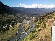
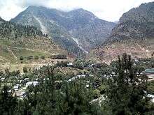
The Sind Valley is situated within the jurisdiction of Kangan tehsil, of Ganderbal district. It is bordered by the Kashmir Valley in the west, Zojila in the east, Kishanganga in the north and the Lidder Valley in the south.[8] It has a length of 65 kilometres (40 mi) and reaches a maximum length of 9 kilometres (5.6 mi) at village Preng towards the north through a stream Wangath Nala which flows down from Gangabal Lake. At some places the width is less than 500 metres (1,600 ft) which gives only space to NH 1D, a National Highway which connects Ladakh and the Kashmir Valley. It is formed by the flow of the Sind River which flows down from east to west. The River originates from the inner Himalayas at Drass in Machoi Glacier[9][10] and runs through green forests of pine and fir and alpine meadows of Sonamarg. The Sind Valley contributes heavily to the economy of the State, through generation of hydroelectricity, provides fresh water supply to other districts and irrigation for agriculture. The Sind River flows through the entire valley passing several natural landmarks, tourist spots including Baltal, The meadow of gold, Gagangear, Naranag and Wayil.[11] The main towns in the valley are Gund, Mammer, Kangan, Wangath, Preng, Wussan and Manigam.
Geology
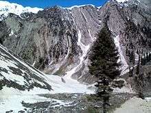
The Sind Valley has formed over a period of several thousand years as the Sind River cuts into the Himalayan mountains. The glaciers of the valley are shrinking.[12] Today, the river continues to deposit the sheets of sand in the lower areas of Ganderbal.[13] Gradual erosive processes have washed away side forests and created a deep gorge at many places.
Ecology
The Sind Valley has many glacier fed streams, the tributaries of the Sind River are home to different types of trout among of which is the brown trout.[14] The valley is the natural habitat of Himalayan black bear, the Himalayan brown bear, musk deer, snow leopard and hangul.[15] Markhor and ibex are also spotted in Sonamarg of the Sind Valley.[16]
References
- ↑ "Census of India 2001: Data from the 2001 Census, including cities, villages and towns (Provisional)". Census Commission of India. Archived from the original on 2004-06-16. Retrieved 2008-11-01.
- ↑ "Sonamarg as a climbing centre". himalayanclub. Retrieved 2012-06-18.
- ↑ Eric S. Margolis (2000). War at the Top of the World: The Struggle for Afghanistan, Kashmir, and Tibet. Routledge, 2000. p. 123–. ISBN 9780415927123. Retrieved 2 July 2012.
- ↑ S.R. Bakshi (1997). Kashmir: History and People Volume 1 of Kashmir through ages. Sarup & Sons, 1997. p. 78–. ISBN 9788185431963. Retrieved 2 July 2012.
- ↑ Saligram Bhatt (2008). Kashmiri Scholars Contribution to Knowledge and World Peace: Proceedings of National Seminar by Kashmir Education Culture & Science Society (K.E.C.S.S.), New Delhi. APH Publishing, 2008. p. 110–. ISBN 9788131304020. Retrieved 2 July 2012.
- ↑ Jalees Ahmed Khan Tareen (2005). Fire Under Snowflakes: The Return of Kashmir University. Mittal Publications, 2005. p. 90–. ISBN 9788183240673. Retrieved 2 July 2012.
- ↑ Moonis Raza, Aijazuddin Ahmad, Ali Mohammad (1978). The Valley of Kashmir: The land. Vikas Pub. House, 1978. p. 31–. ISBN 9780706905250. Retrieved 2 July 2012.
- ↑ Subodh Kapoor (2002). The Indian Encyclopaedia: Gautami Ganga -Himmat Bahadur. Genesis Publishing Pvt Ltd, 2002. p. 2872–. ISBN 9788177552669. Retrieved 18 June 2012.
- ↑ Lulu. Explore Kashmiri Pandits. Lulu.com. p. 37–. ISBN 9780963479860. Retrieved 2 July 2012.
- ↑ Kalhana (2001). Kalhana's Rajatarangini: A Chronicle of the Kings of Kasmi. Elibron.com, 2001. p. 12–. ISBN 9781402173486. Retrieved 2 July 2012.
- ↑ Chris Ackerley, Lawrence Jon Clipper (1984). A Companion to Under the Volcano. UBC Press, 1984. pp. 129, 130–. ISBN 9780774801997. Retrieved 18 June 2012.
- ↑ Geological Society of London (1890). The Quarterly journal of the Geological Society of London, Volume 46. The Society, 1890. p. 66–. ISBN 9788170354895. Retrieved 2 July 2012.
- ↑ Sir Walter Roper Lawrence (1895). The Valley of Kashmir. Asian Educational Services, 1895. p. 47–. ISBN 9788120616301. Retrieved 18 June 2012.
- ↑ A Kumar (2008). Environmental Science: Appreciation & Perception. Daya Books, 2008. p. 133–. ISBN 9788170354895. Retrieved 2 July 2012.
- ↑ Trevor Drieberg (1978). Jammu and Kashmir: a tourist guide. Vikas Pub. House, 1978. p. 115–. ISBN 9780706905755. Retrieved 18 June 2012.
- ↑ Gardeners' chronicle, horticultural trade journal, Part 2. Haymarket Publishing, 1875. 1875. p. 715–. Retrieved 2 July 2012.
External links
- [Onway to Sonmarg through Sind Valley YouTube https://www.youtube.com/watch?v=xunbdCc0jZY&feature=youtube_gdata_player]