Siloam, Georgia
| Siloam, Georgia | |
|---|---|
| Town | |
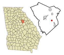 Location in Greene County and the state of Georgia | |
| Coordinates: 33°32′8″N 83°4′50″W / 33.53556°N 83.08056°WCoordinates: 33°32′8″N 83°4′50″W / 33.53556°N 83.08056°W | |
| Country | United States |
| State | Georgia |
| County | Greene |
| Area | |
| • Total | 1.24 sq mi (3.21 km2) |
| • Land | 1.21 sq mi (3.14 km2) |
| • Water | 0.03 sq mi (0.08 km2) |
| Elevation | 702 ft (214 m) |
| Population (2010) | |
| • Total | 282 |
| • Density | 233/sq mi (89.9/km2) |
| Time zone | Eastern (EST) (UTC-5) |
| • Summer (DST) | EDT (UTC-4) |
| ZIP code | 30665 |
| Area code(s) | 706 |
| FIPS code | 13-70932[1] |
| GNIS feature ID | 0356535[2] |
Siloam is a town in Greene County, Georgia, United States. The population was 282 at the 2010 census,[3] down from 331 at the 2000 census.
Geography
Siloam is located in eastern Greene County at 33°32′8″N 83°4′50″W / 33.53556°N 83.08056°W (33.535691, -83.080443).[4] Georgia State Route 15 passes through the town as Main Street, leading northwest 7 miles (11 km) to Greensboro, the county seat, and south 5.5 miles (8.9 km) to White Plains. State Route 77 leads north from the center of town 6 miles (10 km) to Union Point. Interstate 20 passes through the northern side of town, with access from Exit 138 (State Route 77). I-20 leads east 64 miles (103 km) to Augusta and west 80 miles (130 km) to Atlanta.
According to the United States Census Bureau, Siloam has a total area of 1.2 square miles (3.2 km2), of which 0.031 square miles (0.08 km2), or 2.38%, is water.[3]
Demographics
| Historical population | |||
|---|---|---|---|
| Census | Pop. | %± | |
| 1920 | 243 | — | |
| 1930 | 269 | 10.7% | |
| 1940 | 318 | 18.2% | |
| 1950 | 324 | 1.9% | |
| 1960 | 321 | −0.9% | |
| 1970 | 319 | −0.6% | |
| 1980 | 446 | 39.8% | |
| 1990 | 329 | −26.2% | |
| 2000 | 331 | 0.6% | |
| 2010 | 282 | −14.8% | |
| Est. 2015 | 280 | [5] | −0.7% |
As of the census[1] of 2000, there were 331 people, 121 households, and 78 families residing in the town. The population density was 269.8 people per square mile (103.9/km²). There were 144 housing units at an average density of 117.4 per square mile (45.2/km²). The racial makeup of the town was 25.38% White, 73.11% African American, 0.60% Asian, 0.91% from other races. Hispanic or Latino of any race were 2.42% of the population.
There were 121 households out of which 25.6% had children under the age of 18 living with them, 28.1% were married couples living together, 29.8% had a female householder with no husband present, and 35.5% were non-families. 28.9% of all households were made up of individuals and 17.4% had someone living alone who was 65 years of age or older. The average household size was 2.74 and the average family size was 3.38.
In the town the population was spread out with 27.2% under the age of 18, 11.2% from 18 to 24, 22.1% from 25 to 44, 23.6% from 45 to 64, and 16.0% who were 65 years of age or older. The median age was 38 years. For every 100 females there were 79.9 males. For every 100 females age 18 and over, there were 79.9 males.
The median income for a household in the town was $23,125, and the median income for a family was $24,792. Males had a median income of $21,250 versus $19,821 for females.
References
- 1 2 "American FactFinder". United States Census Bureau. Retrieved 2008-01-31.
- ↑ "US Board on Geographic Names". United States Geological Survey. 2007-10-25. Retrieved 2008-01-31.
- 1 2 "Geographic Identifiers: 2010 Demographic Profile Data (G001): Siloam town, Georgia". American Factfinder. U.S. Census Bureau. Retrieved November 29, 2016.
- ↑ "US Gazetteer files: 2010, 2000, and 1990". United States Census Bureau. 2011-02-12. Retrieved 2011-04-23.
- ↑ "Annual Estimates of the Resident Population for Incorporated Places: April 1, 2010 to July 1, 2015". Retrieved July 2, 2016.
- ↑ "Census of Population and Housing". Census.gov. Retrieved June 4, 2015.
External links
- Bethany Presbyterian Church historical marker
Municipalities and communities of Greene County, Georgia, United States | ||
|---|---|---|
| Cities | 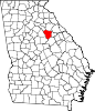 | |
| Town | ||
| Unincorporated community | ||
| Ghost town | ||