Sibley, Kansas
| Sibley, Kansas | |
|---|---|
| Ghost Town | |
| Coordinates: 39°36′54″N 97°42′5″W / 39.61500°N 97.70139°WCoordinates: 39°36′54″N 97°42′5″W / 39.61500°N 97.70139°W | |
| Country | United States |
| State | Kansas |
| County | Cloud |
| Area | |
| • Total | 35.9 sq mi (92.9 km2) |
| • Land | 35.4 sq mi (91.6 km2) |
| • Water | 0.5 sq mi (1.3 km2) |
| Elevation | 1,375 ft (419 m) |
| Population (2000) | |
| • Total | 178 |
| • Density | 5.0/sq mi (1.9/km2) |
| Time zone | Central (CST) (UTC-6) |
| • Summer (DST) | CDT (UTC-5) |
| FIPS code | 20-65425 [1] |
| GNIS feature ID | 0485433 [2] |
Sibley was a settlement in Cloud County, Kansas, United States, north of Concordia and the Republican River.
History
Sibley was founded in 1869, and named for Lake Sibley.[3] It was once in the running for the county seat but lost in an 1870 run-off election against Concordia.[4] The area is now abandoned as a town and the land is privately owned and used for farming. It is considered a ghost town.
Notable people
- May Louise Cowles, economist who studied clothing consumption and consumer behavior[5]
References
- ↑ "American FactFinder". United States Census Bureau. Retrieved 2008-01-31.
- ↑ "US Board on Geographic Names". United States Geological Survey. 2007-10-25. Retrieved 2008-01-31.
- ↑ Hollibaugh, E. F. (1903). Biographical History of Cloud County, Kansas: Biographies of Representative Citizens. Illustrated with Portraits of Prominent People, Cuts of Homes, Stock, Etc. Wilson, Humphrey & Company. p. 152.
- ↑ 'It Takes People to Make a Town, Emery, Janet Pease. (1970a), Salina, Kansas: Arrow Printing. Library of Congress: 75-135688.
- ↑ University of Wisconsin May Louise Cowles, rural sociologist (1892-1978)
External links
| Wikimedia Commons has media related to Sibley, Kansas. |
Municipalities and communities of Cloud County, Kansas, United States | ||
|---|---|---|
| Cities | 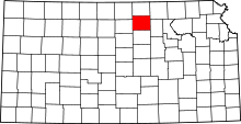 | |
| Unincorporated communities | ||
| Townships | ||
| Footnotes | ‡This populated place also has portions in an adjacent county or counties | |
This article is issued from Wikipedia - version of the 10/29/2016. The text is available under the Creative Commons Attribution/Share Alike but additional terms may apply for the media files.