Newton, Kansas
| Newton, Kansas | |
|---|---|
| City | |
|
Newton City Hall (2006) | |
 Location within Harvey County and Kansas | |
 KDOT map of Harvey County (legend) | |
| Coordinates: 38°2′39″N 97°20′51″W / 38.04417°N 97.34750°WCoordinates: 38°2′39″N 97°20′51″W / 38.04417°N 97.34750°W[1] | |
| Country | United States |
| State | Kansas |
| County | Harvey |
| Founded | 1871 |
| Incorporated | 1872, 1880 |
| Government | |
| • Type | Council-Manager |
| • Mayor | Glen Davis |
| • City Manager | Jeremy Nisly |
| Area[2] | |
| • Total | 12.60 sq mi (32.63 km2) |
| • Land | 12.60 sq mi (32.63 km2) |
| • Water | 0 sq mi (0 km2) |
| Elevation[1] | 1,447 ft (441 m) |
| Population (2010)[3] | |
| • Total | 19,132 |
| • Estimate (2015)[4] | 19,216 |
| • Density | 1,500/sq mi (590/km2) |
| Time zone | CST (UTC-6) |
| • Summer (DST) | CDT (UTC-5) |
| ZIP code | 67114 |
| Area code | 316 |
| FIPS code | 20-50475 [1] |
| GNIS feature ID | 0484319 [1] |
| Website | newtonkansas.com |

Newton is a city in and the county seat of Harvey County, Kansas, United States.[1] As of the 2010 census, the city population was 19,132.[5] Newton is located 25 miles (40 km) north of Wichita. The city of North Newton is located immediately north, existing as a separate political entity.
History
19th century


For millennia, the land now known as Kansas was inhabited by Native Americans. In 1803, most of modern Kansas was secured by the United States as part of the Louisiana Purchase. In 1854, the Kansas Territory was organized, then in 1861 Kansas became the 34th U.S. state. In 1872, Harvey County was founded.
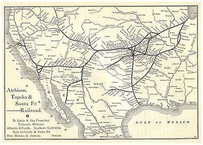
In 1871, the Atchison, Topeka and Santa Fe Railway extended a main line from Emporia westward to Newton by July 1871.[6] The town soon became an important railroad shipping point of Texas cattle.[7]
The city was founded in 1871 and named after Newton, Massachusetts, home of some of the Santa Fe stockholders.[8]
In August 1871, there was a Gunfight at Hide Park, in which a total of eight men were killed. The incident began with an argument between two local lawmen, Billy Bailey and Mike McCluskie. Because of this incident, Newton became known as "bloody and lawless—the wickedest city in the west.".[9]
In 1872, the western terminal for the Atchison, Topeka and Santa Fe Railway and the railhead for the Chisholm Trail were established here. Shortly after incorporation of the city in 1872, the Newton city council passed an ordinance prohibiting the running at large of buffalo and other wild animals.[10]
20th century
During World War II, the Newton airport was taken over by the US Navy as a secondary Naval Air Station, and the main runway was extended to over 7,000 feet (2,100 m).
Newton served as the Middle Division dispatching headquarters for the "Santa Fe" until the mid-1980s, when all dispatching for the Chicago to Los Angeles system was centralized in the Chicago area. In 1995, the Santa Fe merged with the Burlington Northern Railroad, and is now known as the BNSF Railway. The BNSF continues to be a large industrial taxpayer although its impact as an employer has decreased in the past decade. Most locals still refer to this railroad as the "Santa Fe".
21st century
On February 25, 2016, Newton was the site of the first of several related shooting incidents, which culminated in a mass shooting at an Excel Industries building in nearby Hesston that left three people dead and twelve others injured.[11][12] The shooter, identified as Excel employee Cedric Larry Ford, was then killed by responding police officers.[13][14][15]
Geography
Newton is located at 38°2′39″N 97°20′51″W / 38.04417°N 97.34750°W (38.044089, -97.347597).[1] According to the United States Census Bureau, the city has a total area of 12.60 square miles (32.63 km2), all of it land.[2]
The city is in the central portion of the continental United States. U.S. Highway 81, also known as the Meridian Highway, stretches from Winnipeg, Manitoba, Canada to Mexico City, Mexico through Central and South America. It passes through Newton, Kansas and is known as "Main Street." U.S. Highway 50 runs past the White House in Washington, DC through Newton, Kansas and continues on to Sacramento, California.
Climate
The climate in this area is characterized by hot, humid summers and generally mild to cool winters. According to the Köppen Climate Classification system, Newton has a humid subtropical climate, abbreviated "Cfa" on climate maps.[16]
Demographics

| Historical population | |||
|---|---|---|---|
| Census | Pop. | %± | |
| 1880 | 2,601 | — | |
| 1890 | 5,605 | 115.5% | |
| 1900 | 6,208 | 10.8% | |
| 1910 | 7,862 | 26.6% | |
| 1920 | 9,781 | 24.4% | |
| 1930 | 11,034 | 12.8% | |
| 1940 | 11,048 | 0.1% | |
| 1950 | 11,590 | 4.9% | |
| 1960 | 14,877 | 28.4% | |
| 1970 | 15,439 | 3.8% | |
| 1980 | 16,332 | 5.8% | |
| 1990 | 16,700 | 2.3% | |
| 2000 | 17,190 | 2.9% | |
| 2010 | 19,132 | 11.3% | |
| Est. 2015 | 19,216 | [4] | 0.4% |
| U.S. Decennial Census[17] | |||
Newton is included in the Wichita metropolitan statistical area (MSA). It is located in Harvey County which is an agricultural and small manufacturing county with 34,361 people. Harvey County Kansas is part of a 5 county Metro Area with 650,000 people, the largest anchored in the state of Kansas. The major city in this metro area is Wichita, Kansas, 20 miles (20 minutes) to the South via I-135.
2010 census
As of the census[3] of 2010, there were 19,132 people, 7,584 households, and 5,045 families residing in the city. The population density was 1,518.4 inhabitants per square mile (586.3/km2). There were 8,237 housing units at an average density of 653.7 per square mile (252.4/km2). The racial makeup of the city was 88.4% White, 2.2% African American, 0.9% Native American, 0.8% Asian, 4.7% from other races, and 2.9% from two or more races. Hispanic or Latino of any race were 16.3% of the population.
There were 7,584 households of which 33.1% had children under the age of 18 living with them, 51.5% were married couples living together, 10.3% had a female householder with no husband present, 4.7% had a male householder with no wife present, and 33.5% were non-families. 29.1% of all households were made up of individuals and 12.3% had someone living alone who was 65 years of age or older. The average household size was 2.46 and the average family size was 3.01.
The median age in the city was 36.8 years. 26.4% of residents were under the age of 18; 7.9% were between the ages of 18 and 24; 24.9% were from 25 to 44; 25% were from 45 to 64; and 15.9% were 65 years of age or older. The gender makeup of the city was 48.4% male and 51.6% female.
2000 census
As of the census[18] of 2000, there were 17,190 people, 6,851 households, and 4,610 families residing in the city. The population density was 1,794.0 people per square mile (692.8/km²). There were 7,277 housing units at an average density of 759.5 per square mile (293.3/km²). The racial makeup of the city was 86.73% White, 2.30% African American, 0.53% Native American]], 0.66% Asian, 0.03% Pacific Islander, 6.84% from other races, and 2.92% from two or more races. Hispanic or Latino of any race were 12.73% of the population.
There were 6,851 households out of which 31.9% had children under the age of 18 living with them, 54.2% were married couples living together, 9.6% had a female householder with no husband present, and 32.7% were non-families. 28.9% of all households were made up of individuals and 12.1% had someone living alone who was 65 years of age or older. The average household size was 2.43 and the average family size was 2.99.
In the city the population had 26.3% under the age of 18, 8.1% from 18 to 24, 28.2% from 25 to 44, 20.8% from 45 to 64, and 16.5% who were 65 years of age or older. The median age was 37 years. For every 100 females there were 93.3 males. For every 100 females age 18 and over, there were 90.1 males.
As of 2000 the median income for a household was $38,236, and the median income for a family was $45,703. Males had a median income of $32,308 versus $21,906 for females. The per capita income for the city was $18,529. About 5.1% of families and 7.9% of the population were below the poverty line, including 9.7% of those under age 18 and 5.6% of those age 65 or over.
Area attractions
- Kansas Sports Museum[19]
- Harvey County Historical Society Library and Museum[20]
- Kauffman Museum[21]
- Warkentin House, a Victorian house museum.
- Mennonite Settler statue
- Blue Sky Sculpture
- Carriage Factory Art Gallery[22]
- Sand Creek Station Golf Course,[23] 18-hole public course, ranked among 2006's best new public courses in America by Golf Digest.
Education
Primary and secondary education

Newton is part of Unified School District 373.[24] Students from North Newton and Walton attend middle and upper grades in Newton. Newton public schools consist of:
- High School
- Intermediate Schools
- Santa Fe 5/6 Center.
- Chisholm Middle School.
- Elementary
- Northridge Elementary.
- Slate Creek Elementary.
- South Breeze Elementary.
- Sunset Elementary.
- Walton Rural Life Center (in Walton).
- Early Education
- Cooper Early Education
- Private
Newton has two K-8 private schools:
College
- Bethel College is located nearby in the city of North Newton.
- Hutchinson Community College has a satellite campus at the Axtell Education Center, close to downtown.
Media
Newton is served by local media as well as that of Wichita and national media. The following lists include both local media and media from the Wichita MSA.
Print media
The Newton Kansan (GateHouse Media) serves Newton and the surrounding area as the daily local newspaper. It is not published on Sundays or Mondays. The Wichita Eagle is the major newspaper for the region. The Newton Now newspaper is also a newspaper based in Newton and covers some of Harvey County.
Television
- ATSC (digital television)
- Channel 3-1: KSNW - NBC National Broadcasting Company
- Channel 8-1: KPTS - PBS Public Broadcasting Company
- Channel 8-2: KPTS - PBS Public Broadcasting Company
- Channel 8-3: KPTS - PBS Public Broadcasting Company
- Channel 10-1 KAKE - ABC American Broadcasting Company
- Channel 12-1: KWCH - CBS Columbia Broadcasting System
- Channel 12-2: KWCH - CBS 24-hour weather
- Channel 24-1: KSAS - Fox FOX Broadcasting Company
- Channel 33-1: KSCW-DT - CW The CW Television Network
- Channel 36-1: KMTW - MyTV MyNetwork Television
Cox Communications supplies Newton with cable Television
Radio
- AM
- KJRG-AM 950 kHz, Christian talk
- FM
- KKGQ-FM 92.3 MHz, Q92 "The Beat", rhythmic contemporary music
- KBCU-FM 88.1 MHz - Bethel College (Kansas) - College events and Jazz music
Infrastructure
Transportation

BNSF Railway pass through Newton for transportation and shipping. Amtrak's Southwest Chief stops in Newton twice each day and provides passenger rail service towards Los Angeles and Chicago.[27] The Amtrak station is located at 414 N Main St.[28]
Bus service is provided daily towards Wichita and Salina by BeeLine Express (subcontractor of Greyhound Lines).[29][30]
Major roads that pass through Newton are I-135, US-50, US-81, K-15.
Newton City/County Airport, FAA:EWK,[31] is located 2 miles east of Newton. Its 7,002-foot (2,134 m) runway is one of only 11 runways in Kansas 7,000-foot (2,100 m) or longer. It has ILS and GPS approach.[32][33]
Utilities
- Internet
- Cable is provided by Cox Communications.
- Wireless is provided by Pixius Communications.
- Satellite is provided by HughesNet, StarBand, WildBlue.
- TV
- Cable is provided by Cox Communications.
- Satellite is provided by DirecTV, Dish Network.
- Terrestrial is provided by regional digital TV stations.
- Telephone
- Landline is provided by AT&T.
- Cellular is provided by Verizon Wireless, Sprint, and AT&T Mobility.
- Electricity
- City is provided by Westar Energy.
- Gas is provided by Kansas Gas Service.
- Water
- City is provided by City of Newton.
- Rural is provided by Harvey County RWD #1.
- Sewer is billed by City of Newton.
- Trash is billed by City of Newton.
Notable people
- Tom Adair, screenwriter, musician, and composer
- Donna Atwood, figure skater and Ice Capades star
- Errett Bishop, mathematician
- Tony Clark, MLB first baseman and union executive
- Reed Crandall, comic book artist
- James Earp, brother of Wyatt Earp
- Harold E. Foster, head coach of Wisconsin Badgers men's basketball team, member of Naismith Memorial Basketball Hall of Fame[34]
- Elizabeth Hoisington, U.S. Army general
- John Mills Houston, politician and Mayor of Newton[35]
- John M. Janzen, professor of anthropology and author
- J.E. Keeny, president of Louisiana Tech University (1908–26); operated a mercantile store in Newton in 1886[36]
- Dustin Richardson, MLB pitcher
- Jacob A. Schowalter, philanthropist. founder of Schowalter Foundation and Kansas State Representative.
- Jesse Unruh, California politician
- Mike Wellman, NFL center
See also
- Newton High School
- Abilene Trail
- Chisholm Trail
- Gunfight at Hide Park
- National Register of Historic Places listings in Harvey County, Kansas
- La Junta Subdivision, branch of the BNSF Railway
- Arkansas Valley Interurban Railway
Further reading
- Bernhard Warkentin and the Kansas Mennonite Pioneers; David A. Haury; Mennonite Life; December 1974.
References
- 1 2 3 4 5 6 Geographic Names Information System (GNIS) details for Newton, Kansas; United States Geological Survey (USGS); October 13, 1978.
- 1 2 "US Gazetteer files 2010". United States Census Bureau. Retrieved 2012-07-06.
- 1 2 "American FactFinder". United States Census Bureau. Retrieved 2012-07-06.
- 1 2 "Annual Estimates of the Resident Population for Incorporated Places: April 1, 2010 to July 1, 2015". Retrieved July 2, 2016.
- ↑ "2010 City Population and Housing Occupancy Status". U.S. Census Bureau. Retrieved March 6, 2011.
- ↑ Santa Fe Rail History
- ↑ Blackmar, Frank Wilson (1912). Kansas: A Cyclopedia of State History, Volume 2. Standard Publishing Company. p. 367.
- ↑ Harvey County History
- ↑ Smith, Jessica (2013). "Morality and Money: A Look at how the Respectable Community Battled the Sporting Community over Prostitution in Kansas Cowtowns, 1867-1885" (PDF). Kansas State University.
- ↑ Route of the Chisholm cattle trail in Kansas; Kansas Historical Society, 1960s.
- ↑ "Excel Industries shooter identified as Cedric Ford". KWCH. February 25, 2016. Retrieved February 25, 2016.
- ↑ Berman, Mark; Miller, Michael E. (February 25, 2016). "Kansas gunman kills three people and injures 14 people, sheriff says". The Washington Post. Retrieved February 25, 2016.
- ↑ "4 dead, 14 injured in Kansas shooting, shooter ID'd". Russia Today. February 25, 2016. Retrieved February 25, 2016.
- ↑ "Gunman Among 4 Dead, 14 Hurt in Kansas Workplace Shooting". NBC New York. February 25, 2016. Retrieved February 25, 2016.
- ↑ Eversley, Melanie (February 25, 2016). "Multiple dead plus shooter after Kansas shootings; up to 20 injured". USA Today. Retrieved February 25, 2016.
- ↑ Climate Summary for Newton, Kansas
- ↑ United States Census Bureau. "Census of Population and Housing". Retrieved November 30, 2014.
- ↑ "American FactFinder". United States Census Bureau. Retrieved 2008-01-31.
- ↑ Kansas Sports Museum - Kansas Travel
- ↑ Harvey County Historical Society Library and Museum
- ↑ Kauffman Museum
- ↑ Carriage Factory Art Gallery
- ↑ Sand Creek Station Golf Course
- ↑ USD 373.
- ↑ St. Mary's Catholic School
- ↑ Newton Bible Christian School.
- ↑ Amtrak - Southwest Chief route
- ↑ Amtrak - Newton Station
- ↑ BeeLine Express
- ↑ Greyhound Lines
- ↑ Newton City/County Airport map
- ↑ Newton City/County Airport web site
- ↑ Newton City/County Airport information
- ↑ Basketball Hall Of Fame - Harold E. Foster
- ↑ http://www.kshs.org/kansapedia/kansans-in-u-s-congress/14490
- ↑ "Keeny, John Ephraim". Louisiana Historical Association, A Dictionary of Louisiana Biography (lahistory.org). Retrieved December 27, 2010.
External links
| Wikimedia Commons has media related to Newton, Kansas. |
| Wikivoyage has a travel guide for Newton (Kansas). |
- City
- City of Newton
- Newton - Directory of Public Officials
- Newton Area Chamber of Commerce & Visitors Bureau
- City Data
- Schools
- USD 373, school district for Newton, North Newton, Walton
- USD 373 School District Maps
- Historical
- Harvey County Genealogical Society
- Harvey County Roots
- Historic Images of Newton, Special Photo Collections at Wichita State University Library
- Maps
- Newton City Map, KDOT
- Topo Map of Newton / North Newton / Walton area, USGS
- Harvey County Maps: Current, Historic, KDOT
Municipalities and communities of Harvey County, Kansas, United States | ||
|---|---|---|
| Cities |  | |
| Unincorporated communities | ||
| Ghost town |
| |
| Townships | ||
| Footnotes | ‡This populated place also has portions in an adjacent county or counties | |