Shiant Isles

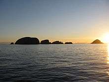
The Shiant Isles (Gaelic: Na h-Eileanan Seunta or Na h-Eileanan Mòra) are a privately owned island group in the Minch, east of Harris in the Outer Hebrides of Scotland. They are five miles south east of Lewis.[1]
Etymology
The name "Shiant" (pronounced "Shant") is from the Scottish Gaelic: Na h-Eileanan Seunta pronounced [nə ˈhelanən ˈʃiant̪ə], which means the "charmed", "holy" or "enchanted isles". The group is also known as Na h-Eileanan Mòra, "the big isles" [nə ˈhelanən ˈmoːɾə]. The main islands are Garbh Eilean (rough island) and Eilean an Taighe (house island), which are joined by a narrow isthmus, and Eilean Mhuire (island of the Virgin Mary) to the east. Eilean an Taighe was called Eilean na Cille (island of the church) prior to the 19th century.[2][3][Note 1]
A 17th-century chart by John Adair calls Garbh Eilean Nunaltins Isle, Eilean Mhuire St Marys Isle and Eilean an Taighe St Columbs Isle This last suggests that the chapel on E. an Taighe might have been dedicated to St Columba.(John N. Moore, 'John Adair's Contribution to the Charting of the Scottish Coasts: A Re-Assessment', Imago Mundi, Vol. 52 (2000), pp. 43–65)
Geography and geology

The Shiant Isles lie east of the Sound of Shiant. Garbh Eilean and Eilean an Taighe together extend to 143 hectares (350 acres)[2] and the much more fertile Eilean Mhuire to 75 hectares (190 acres).[5] In addition to these main islands the line of Galtachan rocks that lie to the west include Galta Beag, Bodach, Stacan Laidir, Galta Mòr, Sgeir Mhic a' Ghobha and Damhag.[6]
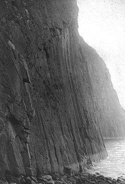
In geological terms, these islands essentially represent an extension of the Trotternish peninsula of Skye. The rocks are volcanic, and at 60Ma, very young by Hebridean standards. Dolerite columns on the north side of Garbh Eilean are over 120 metres (390 ft) tall and about 2 metres (6.6 ft) in diameter. Similar to those at Staffa and the Giant's Causeway and much higher in places, they were formed by the slow cooling of volcanic rocks deep underground.[2][7] Intrusive sills show a progression in their chemical compositions, from olivine-rich rocks at the base to rocks with very little or no olivine at the top.
The sills are thought to have formed by crystal settling. Recent study has suggested that at least one of the sills represents a multiple intrusion.[8] In some places the basalt is overlain by Jurassic mudstone, which weathers to form much more fertile soil than elsewhere in the Western Isles.
The islands can be visited via various cruises from other Hebridean Islands and from mainland Scotland.
History

In 1549, Donald Monro, Dean of the Isles wrote of:
ane ile callit Ellan Senta, that is in English a Saw, ane ile mair than twa myle lang, verey profitable for corne, store, and fishing, perteining to M’Cloyd of the Lewis. On the eist side of this ile ther is a bore, maid like a vylt, mair nore an arrow shot of any man under the eirde, through the quilk vylt we use to row ore saill with our bottis, for fear of the horrible breake of the seas that is on the outwar side thereof, bot na grate ships can saill ther.[9][10][Note 2]
A century and a half later Martin Martin stated that
the two southern islands are separated only by spring-tides, and are two miles in circumference. Island-More hath a chapel in it dedicated to the Virgin Mary, and is fruitful in corn and grass; the island joining to it on the west is only for pasturage.[13][Note 3]
At the beginning of the twentieth century, the Shiant Isles had a population of eight.[1] The author and politician Compton MacKenzie owned the islands from 1925 until 1937. He was an island lover who, at different points in his life rented Herm in the Channel Islands. He never lived on the Shiants, but paid several brief visits during his time as owner.[1]
In 1937 the islands were acquired by Nigel Nicolson, then an undergraduate at Oxford, from monies left to him by his grandmother. Like MacKenzie, Nicolson was later a writer, publisher and politician. Nicolson's son, the writer Adam Nicolson, published the definitive book on the islands, Sea Room (2001). The Shiants now belong to Adam's son Tom Nicolson. Sheep that had been grazing the islands since the early 19th century were finally removed in the summer of 2016. The simple bothy restored by Nigel Nicolson on Eilean an Taighe is the only habitable structure on the islands.[15] A visit to the islands is described in The Old Ways by Robert Macfarlane.[16]
Wildlife
The Shiant Isles have a large population of seabirds, including tens of thousands of Atlantic puffins breeding in burrows on the slopes of Garbh Eilean, as well as significant numbers of common guillemots, razorbills, northern fulmars, black-legged kittiwakes, common shags, gulls and great skuas. Although the remote island of St Kilda has more puffins, the sheer density on the Shiants is greater.[7][18]
The islands were also home to a colony of black rats, which may originally have come ashore from a shipwreck.[19] Apart from one or two small islands in the Firth of Forth, the Shiants were the only place in the UK where the black rat or ship's rat (Rattus rattus) could still be found.[20] There was thought to be a winter population about 3,500 rats on the islands. Those numbers rose exponentially during the summer. Analysis of their stomach contents had shown that the Shiant rats did eat seabirds, but it was impossible to tell if they preyed on live birds or simply scavenged dead remains.[21] Their numbers had for many years been controlled in and around the house.[22]
Over the winter of 2015/16, a far larger rat control project, sponsored by the RSPB and paid for with contributions from the EU, SNH, the RSPB itself and many individual donors, eradicated the rats from all the Shiant islands permanently.[23]
References
- Notes
- ↑ Nicolson (2002) adds "hallowed", "haunted", "spooky" and "otherworldly" to the possible meanings of sénta, the Irish equivalent of the Scottish Gaelic sianta.[4]
- ↑ Translation from Scots: "an isle called Ellan Senta, which means in English "fable island",[11] an isle more than two miles long, very profitable for grain, stock-rearing and fishing, pertaining to McLeod of Lewis. On the east side of this isle there is a bore, made like a vault, longer(?) than the arrow shot of any man on earth, through which gulping vault we used to row our sail boats, for fear of the horrible break of the seas that is on the outward side, but no large ship can sail through it." Nicolson (2002) calls this "vault" on Toll a' Roimh at the north east end of Garbh Eilean the "Hole of the Seals" and describes rowing a dinghy through it.[12]
- ↑ Martin's poor grasp of the geography contributed to later confusion. "Island-More" must be his translation of Na h-Eileanan Mòra and there was a chapel on Eilean an Taighe (known as Eilean na Cille at the time he was writing). The "island joining to it on the west" must therefore be Garbh Eilean to the north. Martin's description has led to suggestions that the chapel was on Eilean Mhuire, although this seems unlikely.[14]
- Footnotes
- 1 2 3 Keay, J. & Keay, J. (1994) Collins Encyclopaedia of Scotland. London. HarperCollins.
- 1 2 3 Haswell-Smith (2004) pp. 275-76
- ↑ Mac an Tàilleir (2003) p. 105
- ↑ Nicolson (2002) p. 72
- ↑ Nicolson (2002) p. 143
- ↑ Get-a-map. Ordnance Survey. Retrieved 10 April 2011.
- 1 2 "Western Isles Guide Book: Shiant Islands". Retrieved 2007-07-21.
- ↑ Kathryn Goodenough (September 1999). "Geological Conservation Review: Shiant Isles SSSI" (PDF). Scottish Natural Heritage. Retrieved 2007-07-21.
- ↑ Monro (1594) "Ila" No. 175
- ↑ Nicolson (2002) p. 217
- ↑ "Saw". Wiktionary. Retrieved 10 April 2011.
- ↑ Nicolson (2002) pp. 73, 78
- ↑ Martin (1703) p. 35
- ↑ Nicolson (2002) p. 144
- ↑ Nicholson, Adam Sea Room: An Island Life in the Hebrides Harper Collins, 2001 (ISBN 0-00-257164-1)
- ↑ Macfarlane, Robert (2012) The Old Ways Hamish Hamilton.
- ↑ Harvie-Brown, J. A. & Buckley, T. E. (1889), A Vertebrate Fauna of the Outer Hebrides. Pub. David Douglas, Edinburgh. Facing P. XIV.
- ↑ "Birds of the Shiant Islands: 1970 & 1971 census". Shiant Islands. Retrieved 2007-07-21.
- ↑ Haswell-Smith (2004) pp. 276-77
- ↑ "Developing a mammal monitoring programme for the UK" (pdf). Joint Nature Conservation Committee. Retrieved 2007-01-02.
- ↑ Stapp, Paul (2002) "Stable isotopes reveal evidence of predation by ship rats on seabirds on the Shiant Islands". Scotland Journal of Applied Ecology 39 (5), 831–840.
- ↑ A. Nicolson, personal comment.
- ↑ http://www.bbc.com/news/uk-scotland-highlands-islands-27738095; http://www.bbc.com/news/uk-scotland-highlands-islands-27765967; http://www.heraldscotland.com/news/home-news/eu-gives-450000-to-project-aiming-to-clear-islands-of-rats.24428932
- General references
- Benvie, Niall (2004). Scotland's Wildlife. Aurum Press. ISBN 1-85410-978-2.
- Haswell-Smith, Hamish (2004). The Scottish Islands. Edinburgh: Canongate. ISBN 978-1-84195-454-7.
- Mac an Tàilleir, Iain (2003) Placenames/Ainmean-àite le buidheachas (pdf). Pàrlamaid na h-Alba. Retrieved 6 October 2009.
- Martin, Martin (1703) A Description of The Western Islands of Scotland (Circa 1695) . Appin Regiment/Appin Historical Society. Retrieved 3 March 2007
- Monro, Sir Donald (1549) Description of the Western Isles of Scotland. William Auld. Edinburgh - 1774 edition.
- Nicolson, Adam (2002) Sea Room. London. HarperCollins. ISBN 0-00-653201-2
External links
Inhabited islands of the Hebrides | ||
|---|---|---|
| Inner Hebrides | 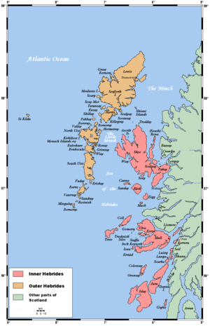 | |
| Outer Hebrides | ||