Kerrera
| Gaelic name |
|
|---|---|
| Norse name | Kjarbarey |
| Meaning of name | Norse for 'Kjarbar's island' or possibly 'copse island' |
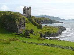 Gylen Castle | |
| Location | |
 Kerrera Kerrera shown within Argyll and Bute | |
| OS grid reference | NM813281 |
| Physical geography | |
| Island group | Mull |
| Area | 1,214 hectares (4.7 sq mi) |
| Area rank | 44 [1] |
| Highest elevation | Carn Breugach 189 metres (620 ft) |
| Administration | |
| Sovereign state | United Kingdom |
| Country | Scotland |
| Council area | Argyll and Bute |
| Demographics | |
| Population | 34[2] |
| Population rank | 57 [1] |
| Pop. density | 2.8 people/km2[2][3] |
| Largest settlement | Bailiemore |
| References | [3][4][5][6] |
Kerrera (Scottish Gaelic: Cearara[7] or Cearrara[4]) is an island in the Scottish Inner Hebrides, close to the town of Oban. In 2011 it had a usually resident population of 34, and it is linked to the mainland by frequent passenger ferry from the Gallanach Road (about 3 km SW of Oban). It is around 7 km long and around 2 km wide, and is separated from the mainland by the Sound of Kerrera, about 500 metres wide.
The island is known for the ruined Gylen Castle, built in 1582. It was also the place where Alexander II of Scotland died in 1249. The highest point on Kerrera is Carn Breugach at 189 m (620 ft). Most of the island is owned by the McDougalls of Dunollie, who are descended from the Scottish prince Somerled. The four-acre (1.6 ha) tidal island at the north-east tip of Kerrera, Rubh a' Chruidh, was sold for £426,000 in 2010 to Lanarkshire businessman David Hamilton.[8]
The main industries on the island are farming (sheep and Highland cattle) and tourism. There is a tea room/café at the south end near Gylen Castle. The castle itself has recently been restored and is open to the public. Oban.
Gallery
 Outline map of Kerrera.
 Sunset over Kerrera, viewed from Oban.

References
- 1 2 Area and population ranks: there are c. 300 islands over 20 ha in extent and 93 permanently inhabited islands were listed in the 2011 census.
- 1 2 National Records of Scotland (15 August 2013) (pdf) Statistical Bulletin: 2011 Census: First Results on Population and Household Estimates for Scotland - Release 1C (Part Two). "Appendix 2: Population and households on Scotland’s inhabited islands". Retrieved 17 August 2013.
- 1 2 Haswell-Smith, Hamish (2004). The Scottish Islands. Edinburgh: Canongate. ISBN 978-1-84195-454-7.
- 1 2 Mac an Tàilleir, Iain (2003) Ainmean-àite/Placenames. (pdf) Pàrlamaid na h-Alba. Retrieved 26 August 2012.
- ↑ Ordnance Survey. Get-a-map (Map). 1:25,000. Leisure. Ordinance Survey. Retrieved 21 August 2013.
- ↑ Anderson, Joseph (ed.) (1873) The Orkneyinga Saga. Translated by Jón A. Hjaltalin & Gilbert Goudie. Edinburgh. Edmonston and Douglas. The Internet Archive. Retrieved 26 August 2013.
- ↑ "Gaelic Place-Names of Scotland database". Ainmean-Àite na h-Alba. Retrieved 1 December 2012.
- ↑ Moira Kerr (15 February 2010). "Scottish island Rubh'a Chruidh sells for £426,000". The Scotsman. Retrieved 16 February 2010.
External links
Inhabited islands of the Hebrides | ||
|---|---|---|
| Inner Hebrides | 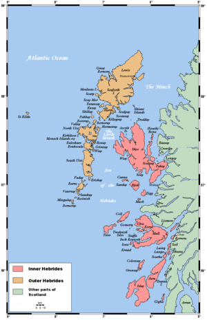 | |
| Outer Hebrides | ||
|  | ||||||||||||||||||||||||||||
|
| |||||||||||||||||||||||||||||
| |||||||||||||||||||||||||||||
| |||||||||||||||||||||||||||||
| |||||||||||||||||||||||||||||
| |||||||||||||||||||||||||||||
| |||||||||||||||||||||||||||||
| |||||||||||||||||||||||||||||
Coordinates: 56°24′N 5°32′W / 56.400°N 5.533°W