Sherwood, Maryland
| Sherwood, Maryland | |
|---|---|
| Unincorporated community | |
 Sherwood | |
| Coordinates: 38°45′41″N 76°19′08″W / 38.76139°N 76.31889°WCoordinates: 38°45′41″N 76°19′08″W / 38.76139°N 76.31889°W | |
| Country | United States |
| State | Maryland |
| County | Talbot |
| Elevation | 7 ft (2 m) |
| Time zone | Eastern (EST) (UTC-5) |
| • Summer (DST) | EDT (UTC-4) |
| ZIP code | 21665 |
| Area code(s) | 410, 443, and 667 |
| GNIS feature ID | 591272[1] |
Sherwood is an unincorporated community in Talbot County, Maryland, United States.[1] Sherwood is located along Maryland Route 33 on the eastern shore of the Chesapeake Bay south of Claiborne and north of Tilghman Island. The United States Postal Service has assigned Sherwood the ZIP Code 21665. The Sandy, a log canoe ported in Sherwood, was listed on the National Register of Historic Places in 1985.[2]
References
- 1 2 "Sherwood". Geographic Names Information System. United States Geological Survey.
- ↑ National Park Service (2010-07-09). "National Register Information System". National Register of Historic Places. National Park Service.
Municipalities and communities of Talbot County, Maryland, United States | ||
|---|---|---|
| Towns | 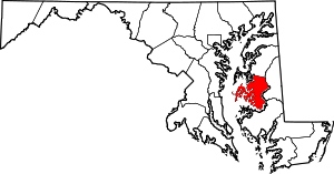 | |
| CDPs | ||
| Other communities | ||
| Footnotes | ‡This populated place also has portions in an adjacent county or counties | |
This article is issued from Wikipedia - version of the 10/28/2016. The text is available under the Creative Commons Attribution/Share Alike but additional terms may apply for the media files.