Wittman, Maryland
| Wittman, Maryland | |
|---|---|
| Unincorporated community | |
 Wittman | |
| Coordinates: 38°47′37″N 76°17′39″W / 38.79361°N 76.29417°WCoordinates: 38°47′37″N 76°17′39″W / 38.79361°N 76.29417°W | |
| Country | United States |
| State | Maryland |
| County | Talbot |
| Elevation | 7 ft (2 m) |
| Time zone | Eastern (EST) (UTC-5) |
| • Summer (DST) | EDT (UTC-4) |
| ZIP code | 21676 |
| Area code(s) | 410, 443, and 667 |
| GNIS feature ID | 591579[1] |
Wittman is an unincorporated community in Talbot County, Maryland, United States.[1] Wittman is located at the intersection of Pot Pie Road, New Road, and Cummings Road south of Claiborne. Although it is unincorporated, it has a post office, with the ZIP code of 21676.[2] The Flying Cloud (log canoe) was listed on the National Register of Historic Places in 1985.[3]
References
- 1 2 "Wittman". Geographic Names Information System. United States Geological Survey.
- ↑ Zip Code Lookup
- ↑ National Park Service (2010-07-09). "National Register Information System". National Register of Historic Places. National Park Service.
Municipalities and communities of Talbot County, Maryland, United States | ||
|---|---|---|
| Towns | 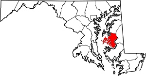 | |
| CDPs | ||
| Other communities | ||
| Footnotes | ‡This populated place also has portions in an adjacent county or counties | |
This article is issued from Wikipedia - version of the 10/28/2016. The text is available under the Creative Commons Attribution/Share Alike but additional terms may apply for the media files.