Shanghai Yangtze River Tunnel and Bridge
| Shanghai Yangtze River Tunnel and Bridge | |||
| Chinese | 上海长江隧桥 | ||
|---|---|---|---|
| |||
The Shanghai Yangtze River Tunnel and Bridge is the collective name given to the bridge-tunnel complex across the south fork of the Yangtze River near the river mouth in Shanghai. The tunnel connects the Pudong District of Shanghai on the south bank of the river with Changxing Island, while the bridge connects Changxing Island with Chongming Island. In combination with the Chongqi Bridge (opened in December 2011), which connects Chongming Island to the north bank of the Yangtze, the bridge-tunnel complex forms the final crossing of the Yangtze before it empties into the East China Sea.
The bridge and tunnel were built from 2005 to 2009 at a cost of 12.6 billion yuan (US$1.84 billion),[1] and opened on 31 October 2009.[1][2] Their combined length is 25.5 km (15.8 mi), forming part of the G40 Shanghai–Xi'an Expressway.
Tunnel
 Entrance to the tunnel | |
| Overview | |
|---|---|
| Location | Shanghai |
| Coordinates | 31°20′26″N 121°41′38″E / 31.340589°N 121.693813°E |
| Start | Wuhaogou, Pudong |
| End | Changxing Island |
| Operation | |
| Constructed | 2005 - 2009 |
| Opened | 31 October 2009 |
| Technical | |
| Length | 8.9 kilometres (5.5 mi) |
| Number of lanes | 2 x 3 |
The Shanghai Yangtze River Tunnel starts on the south bank of the Yangtze at Wuhaogou, Pudong and ends in the south of Changxing Island. It is 8.9 kilometres (5.5 mi) in length,[1] and has two stacked levels. The upper level is for a motorway, and has three lanes in each direction, with a designed speed of 80 kilometres per hour (50 mph). The lower level is reserved for a future Shanghai Metro line, line 19.
The tunnelling was completed using four tunnel boring machines, the largest of which was 15.43 metres (50.6 ft) in diameter,[3] 135 metres (443 ft) long, and weighed 2,300t.
Bridge
| Shanghai Yangtze River Bridge 上海长江大桥 | |
|---|---|
 | |
| Coordinates | 31°26′05″N 121°44′40″E / 31.43481°N 121.74431°ECoordinates: 31°26′05″N 121°44′40″E / 31.43481°N 121.74431°E |
| Crosses | Yangtze River between Changxing and Chongming islands |
| Locale |
Shanghai China |
| Characteristics | |
| Design | Cable-stayed bridge with viaducts |
| Total length |
16,500 m (54,134 ft) (including approaches) |
| Width | 35.3 m (116 ft) |
| Height | 209 m (686 ft) |
| Longest span | 730 m (2,395 ft) |
| Number of spans |
1 cable-stayed span 2 viaducts |
| History | |
| Construction end | 23 Oct 2009 |
| Opened | 31 Oct 2009 |
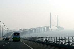
The Shanghai Yangtze River Bridge starts at the tunnel exit, crosses Changxing Island at ground level, then crosses to Chongming Island, ending at Chenjia Town.
It consists of two long viaducts with a higher cable-stayed section in the middle to allow the passage of ships. The total length is 16.63 kilometres (10.33 mi), of which 6.66 kilometres (4.14 mi) is road and 9.97 kilometres (6.20 mi) bridge. The overall shape of the bridge is not linear but slightly sigmoid ("S" shaped).
The central cable-stayed span is about 730 metres (2,395 ft), the longest span of any bridge in Shanghai, and the tenth longest cable-stayed span in the world.[4] The span arrangement is 92+258+730+258+72 m.[5]
The bridge has three road lanes in each direction, with a designed speed of 100 kilometres per hour (62 mph). Room on both flanks of the bridge is reserved for a future metro line, line 19, so total deck width is 35.3 m (115.8 ft).[5]

See also
- Yangtze River bridges and tunnels
- Hangzhou Bay Bridge, a bridge across the Hangzhou Bay connecting Jiangsu and Zhejiang provinces.
- Donghai Bridge, a bridge from Shanghai to the island of Yangshan and the Yangshan Deepwater Port in Hangzhou Bay.
- Yangpu Bridge, a cable-stayed bridge across Huangpu River in Shanghai.
- Lupu Bridge, an arch bridge across Huangpu River in Shanghai.
References
- 1 2 3 Bridge-tunnel linking Chongming Island opens to traffic, Shanghai Daily, 2009-10-31, accessed 3 November 2009
- ↑ "世界最大隧桥上海长江大桥31日通车(组图) (The largest bridge-tunnel project in the world the Shanghai Yangtze River Tunnel and Bridge opens on 31st (multiple pictures))" (in Chinese). Tencent QQ.com News. 31 October 2009. Retrieved 1 January 2010.
- ↑ http://www.herrenknecht.com/en/media/press-information/2014/xxl-tunnel-boring-machines-in-the-yangtze-river-delta.html
- ↑ "上海长江大桥 (Shanghai Yangtze River Bridge)" (in Chinese). Baidu.com Chinese Encyclopedia. 19 June 2009. Retrieved 1 January 2010.
- 1 2 Q.E. Deng, C.Y. Shao: Recent Major Cable-Stayed Bridges in Shanghai
External links
- Shanghai Yantze River Bridge&Tunnel Project Info Website (Chinese)
- The world's largest bridge tunnel opened to traffic in Shanghai
- New City a model for the future
- New bridge can cope with an earthquake
- Pudong to Chongming in 20mins
- 扬子晚报:崇启大桥通过评估
- 长江隧桥项目简介
- SMG:采用最新科技 上海长江隧道做足安全文章
- 新闻午报:上海长江大桥主塔封顶
| Crossings of the Yangtze River | ||||
|---|---|---|---|---|
| ||||
| Over the Yangtze River |  | ||||||
|---|---|---|---|---|---|---|---|
| Over Hangzhou Bay | |||||||
| Over the Huangpu River |
| ||||||
| Other | |||||||