Busan–Geoje Fixed Link
| Busan–Geoje Fixed Link | |
|---|---|
| Coordinates | 35°0′57.2″N 128°44′39″E / 35.015889°N 128.74417°E |
| Carries | NR 58 |
| Locale | Busan, South Korea |
| Characteristics | |
| Design | Fixed link (bridge-tunnel) |
| Total length | 8.2 kilometers (5.1 mi) |
| Longest span | 475 meters (1,558 ft) |
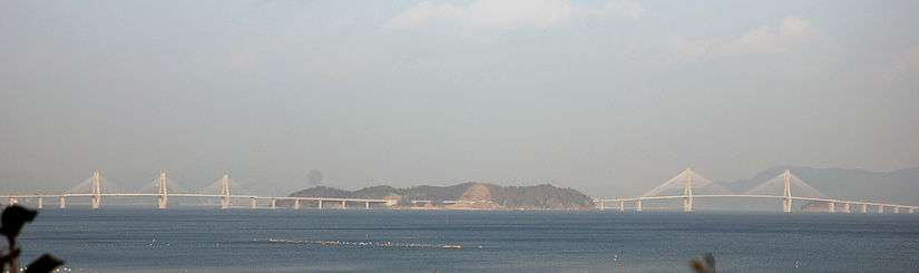
The Busan–Geoje Fixed Link (or Geoga Bridge) is an 8.2 kilometers (5.1 mi) bridge-tunnel fixed link that connects the South Korean city of Busan to Geoje Island. The name of the bridge is Geoga Bridge (거가 대교). The route opened on December 13, 2010[1] and shortens the travelling distance between Geoje Island and Busan by about 60 kilometers (37 mi). The new road has two lanes in each direction and carries National Road 58.[2]
The fixed link opens Geoje Island to tourist-related development and saves US$300 million in costs related to traffic delays from the longer route.[3]
Design and construction
The bridge was built under a public-private partnership. GK Fixed Link Corp, a consortium of seven Korean contractors, has a 40-year contract to build, operate and transfer the fixed link. The project is planned to cost US$1.8 billion. The government has provided only one-fourth of the cost; the rest is financed by the consortium to be repaid by tolls during the life of the contract. The lead contractor in the consortium is Daewoo Engineering & Construction, Co.[4]
Designers involved with the project include COWI A/S (Denmark), Halcrow Group (United Kingdom), Tunnel Engineering Consultants (Netherlands), Pihl and Son (Denmark), Arcadis US (USA), and Ben C. Gerwick (USA).[4]
Route

The route connects Busan, Korea's largest port city, to the shipbuilding industries and tourism destinations on Geoje Island.[5] It replaces either a 210-minute journey by road or a 120-minute journey by ferry. The new route cuts travel time down to 40 minutes.[6]
The fixed link starts on Geoje Island, crosses three islets (Jeo, Jungjuk and Daejuk) and ends on Gaduk Island. In addition to the tunnel between Daejuk and Gaduk islands, a tunnel is used to cross each of the islets.
Bridge 1
The 1.87 km (1.16 mi) bridge between Jungjuk and Jeo islands includes a cable-stayed bridge with a 475 m (1,558 ft) main span and 220 m (720 ft) side spans. This bridge provides 52 meters (171 ft) of navigational clearance and has two 156 m (512 ft) diamond-shaped pylons.[7]
Bridge 2
Between Geoje and Jeo islands, a 1.65 km (1.03 mi) bridge includes a three-pylon cable-stay bridge. This bridge has two mainspans of 230 meters (750 ft) with side spans of 106 meters (348 ft). The pylons are 102 meters (335 ft) tall and there is 36 meters (118 ft) of clearance underneath the bridge.[7]
Tunnel
When it opened, the tunnel became the world’s deepest immersed roadway tunnel (48 meters (157 ft) below mean water level) and the world’s second-longest concrete immersed tunnel, at 3.2 kilometers (2.0 mi).[4] It is Korea's first immersed tunnel.[8] It became the second-deepest immersed vehicle tunnel after completion of the Marmaray (Bosphorus rail tunnel) in 2013.[5]
The tunnel is made up of 180 m (590 ft) segments constructed in a dry dock in Anjeon. Each segment was towed 35 kilometers (22 mi) by barges and sunk into place.[9]
See also
- List of bridges
- List of bridge–tunnels
- Lists of tunnels
- Øresund Bridge
- Tokyo Bay Aqua-Line
- Undersea tunnel
Notes and references
- ↑ "South Korea's first bridge-undersea tunnel link opens". Deccan Herald. December 13, 2010. Retrieved August 25, 2015.
- ↑ Yeoward 2010, p. 26.
- ↑ Cho 2009, p. 25.
- 1 2 3 Cho 2009, p. 24.
- 1 2 Rowson 2009.
- ↑ Halcrow project video (wmv), 1:04 minutes.
- 1 2 Fraser 2008.
- ↑ Halcrow project video (wmv), 29 seconds.
- ↑ Cho 2009, p. 26.
- Cho, Aileen (February 2, 2009). "A Sinking Feeling Is Good in Busan, For Contractors and Their Advisors". Engineering News-Record. New York: McGraw-Hill. 262 (4): 24–29. ISSN 0891-9526. Archived from the original on October 10, 2009.
- Fraser, Don (May 25, 2008). "Vision On". Bridge Design & Engineering. London: Hemming Information Services (51). Archived from the original on October 10, 2009.
- Halcrow Group Limited. "Busan Geoje Fixed Link Project". Archived from the original on October 10, 2009. Retrieved October 10, 2009.
- Halcrow Group Limited. Busan Geoje Fixed Link. Halcrow Group Limited. Archived from the original (wmv) on October 10, 2009. Retrieved October 10, 2009.
- Rowson, Jessica (January 13, 2009). "Korea crossing - Busan Geoje link". New Civil Engineer. London: Emap. Archived from the original on October 10, 2009. Retrieved October 10, 2009.
- Yeoward, Andrew J.; Fraser, Don; Koo, Im Sig; Davis, Daniel G. (September 2010). "Land Locking: South Korean Islands Linked by Mammoth Job" (PDF). Roads & Bridges Magazine. Scranton Gillette Communications. 48 (9): 26–29. Archived from the original (PDF) on September 25, 2010.
External links
- Busan-Geoje Link in the Structurae database. Retrieved on 2009-02-22.
- Busan-Geoje Bridge (I) at Structurae. Retrieved on February 22, 2009.
- Busan-Geoje Bridge (II) at Structurae. Retrieved on February 22, 2009.
- Busan-Geoje Tunnel at Structurae. Retrieved on February 22, 2009.