Donghai Bridge
| Donghai Bridge 东海大桥 | |
|---|---|
 | |
| Coordinates | 30°45.43′N 121°58.13′E / 30.75717°N 121.96883°ECoordinates: 30°45.43′N 121°58.13′E / 30.75717°N 121.96883°E |
| Carries | S2 Hulu Expressway |
| Locale | Shanghai and Yangshan Port |
| Other name(s) | Big East Sea Bridge |
| Characteristics | |
| Design | Beam bridge with cable-stayed section |
| Total length | 32.5 kilometres (20.2 mi) |
| Longest span | 420 metres (1,380 ft) |
| History | |
| Opened | December 10, 2005 |
 Map of Donghai Bridge | |
Donghai Bridge (Chinese: t 東海大橋, s 东海大桥, p Dōnghǎi Dàqiáo, Wu Tonhe Dujiau lit. "East China Sea Bridge") is a Chinese bridge counted among the longest cross-sea bridges in the world. It was completed on December 10, 2005. It has a total length of 32.5 kilometres (20.2 mi) and connects mainland Shanghai's Pudong New Area with the offshore Yangshan Deep-Water Port in Zhejiang's Shengsi County. Most of the bridge is a low-level viaduct. There are also cable-stayed sections to allow for the passage of large ships, the largest with a span of 420 metres (1,380 ft). Donghai Bridge is part of the S2 Hulu Expressway.
The bridge has a long and narrow speedway and does not allow vehicles that do not meet the weight requirements.
Projects
On 29 January 2014, Shanghai's urban planning authorities announced that they would build a second bridge combining road and rail to help meet growing transport demands for the Yangshan deep-water port.[1]
See also
- Donghai Bridge Wind Farm
- Port of Shanghai
- Yangshan deep water port
- Hangzhou Bay Bridge
- Qingdao Haiwan Bridge
- List of bridges by length
- List of longest cable-stayed bridge spans
External links
![]() Media related to Donghai Bridge at Wikimedia Commons
Media related to Donghai Bridge at Wikimedia Commons
Gallery
 Donghai Bridge while under construction
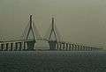 Donghai Bridge main span
References
- ↑ Yang, Bob. "Combined rail and road bridge to island". ShanghaiDaily.com. Retrieved 2 February 2014.