Sha Tin District
| Sha Tin 沙田區 | ||
|---|---|---|
| District | ||
| Sha Tin District | ||
|
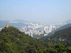
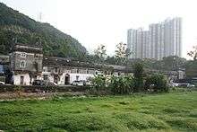
Day view of the Sha Tin District skyline | ||
| ||
 Location of Sha Tin District within Hong Kong | ||
| Coordinates: 22°23′14″N 114°11′43″E / 22.38715°N 114.19534°ECoordinates: 22°23′14″N 114°11′43″E / 22.38715°N 114.19534°E | ||
| Country | Hong Kong | |
| Special administrative region | Hong Kong | |
| Constituencies | 36 | |
| Government | ||
| • District Council Chairman | Ho Hau-cheung, BBS, MH (Civil Force) | |
| Area | ||
| • Total | 69.4 km2 (26.8 sq mi) | |
| Population (2011) | ||
| • Total | 630,273 | |
| • Density | 9,173/km2 (23,760/sq mi) | |
| Time zone | Hong Kong Time (UTC+8) | |
| Website | Sha Tin District Council | |
| Sha Tin District | |||||||||||||||
| Traditional Chinese | 沙田區 | ||||||||||||||
|---|---|---|---|---|---|---|---|---|---|---|---|---|---|---|---|
| Simplified Chinese | 沙田区 | ||||||||||||||
| Literal meaning | "sand field district" | ||||||||||||||
| |||||||||||||||
Sha Tin District is one of the 18 districts of Hong Kong. As one of the 9 districts located in the New Territories, it covers the areas of Sha Tin, Tai Wai, Ma On Shan, Fo Tan, Siu Lek Yuen and Ma Liu Shui. The district is the most populous district in Hong Kong, with a population of 630,273.[1]
The Sha Tin District covers approximately 69.4 km² (26.8 sq. mi),[2] including Sha Tin New Town and several country parks. Built mostly on reclaimed land in Sha Tin Hoi, the well-developed Sha Tin New Town comprises mainly residential areas along the banks of the Shing Mun River Channel. In the early 1970s it was a rural township of about 30,000 people. After Sha Tin's first public housing estate, Lek Yuen Estate, was completed in 1976, the settlement began to expand. Today, about 65% of the district's population live in public rental housing, housing under Hong Kong's Tenants Purchase Scheme, or Home Ownership Scheme.[3]
History
Pre-colonial Era
Sha Tin was formerly named Lek Yuen, literally meaning the "source of trickling" or "source of clear water". The area of the present day Sha Tin was populated before the Ming Dynasty. As the Shing Mun River runs across the district, most local residents were farmers and relied on agriculture for living. In 1579, Tai Wai Village, the oldest and largest walled village in the district was built. Several other villages were built along the river after Tai Wai Village.
Colonial Era
Sha Tin started to be administered by the British Hong Kong government since the Convention for the Extension of Hong Kong Territory was signed. The establishment of the Sha Tin Station of the Kowloon-Canton Railway (British Section) in 1910 caused Sha Tin to be the more common name for the area, replacing Lek Yuen ever since.
Sha Tin was a former market town at the present location of Sha Tin Centre Street and New Town Plaza shopping centre.
Sha Tin Town was the second batch of satellite towns, or new town, to be built in the New Territories, on land reclaimed from the sea.
Land use
In addition to the residential areas, there are four industrial areas for light industries: Tai Wai, Fo Tan, Siu Lek Yuen and Shek Mun.
The Chinese University of Hong Kong is also located in Sha Tin. People typically travel there via the MTR East Rail Line and get off at University station. A minibus service operates on campus.
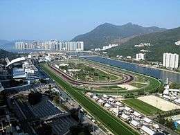
Sha Tin is the location for Hong Kong's second equestrian racecourse (the first and most famous being Happy Valley Racecourse) which has a capacity of 85,000. This course hosted the equestrian events during the 2008 Summer Olympics. The Olympics were hosted by Beijing, but there was concern over proper quarantine and disease monitoring in the Chinese capital.
Penfold Park is located inside the racecourse and closed on race days. It is best accessed via the Fo Tan Station. Sha Tin Park is another major park located in Sha Tin.
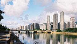
Shing Mun River

The Shing Mun River is a 7 km long, 200m wide channel originating at the Shing Mun Reservoir (Tai Mo Shan catchment) that runs as a river from the Tai Wai area, through the Sha Tin town centre to Tolo Harbour. It has three main tributaries, namely Tai Wai Nullah, Fo Tan Nullah and Siu Lek Yuen Nullah. Along the Shing Mun River are high-rise residential, commercial and industrial buildings with numerous village type developments scattered around.
Transportation
Sha Tin District has the largest number of East Rail Line stations of any district in Hong Kong. It has five stations, namely Tai Wai, Sha Tin, Fo Tan, Racecourse and University. The Ma On Shan Line runs between Tai Wai, Che Kung Temple, Sha Tin Wai, City One, Shek Mun, Tai Shui Hang, Heng On, Ma On Shan, and Wu Kai Sha stations.
A network of cycle tracks throughout Sha Tin measures about 50 km long and is the longest cycle track network in Hong Kong.
Increasing population in the town has exerted pressure on the transportation. Several construction plans have been launched to cope with the demand. The construction of Route T7 linking Ma On Shan Road to Sai Sha Road has been started on January 2001 and completed in 2005. The Route 8 connecting Cheung Sha Wan, Kowloon and Sha Tin is scheduled for construction at the end of 2003 and will complete at the end of 2007. The construction of the Ma On Shan Line (11.4 km long) began in December 2000 and was completed at the end of 2004.
Tai Po Road, Sha Lek Highway, Sha Tin Road, Lion Rock Tunnel, Sai Sha Road, Tate's Cairn Tunnel, Tolo Highway and Shing Mun Tunnels already serve the Sha Tin District.
Education
Secondary schools
- Baptist Lui Ming Choi Secondary School
- Buddhist Wong Wan Tin College
- Immaculate Heart of Mary College
- International Christian School of Hong Kong
- Jockey Club Ti-I College
- Kwok Tak Seng Catholic Secondary School
- Lok Sin Tong Young Ko Hsiao Lin Secondary School
- Morningside College (Hong Kong)
- Mrs. Fung Wong Fung Ting College
- POH Chan Kai Memorial College
- Renaissance College
- S. K. H. Tsang Shiu Tim Secondary School
- S.K.H. Lam Kau Mow Secondary School
- Sha Tin College
- Sha Tin Government Secondary School
- Sha Tin Methodist College
- Shatin Pui Ying College
- Shatin Tsung Tsin Secondary School
Higher education
Hospitals
There are four hospitals in Sha Tin District:
- Prince of Wales Hospital, one of the centres of the 2003 SARS outbreak among health care workers (Ward 8A);
- Sha Tin Hospital;
- Cheshire Home; and
- Union Hospital, a private hospital
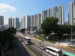
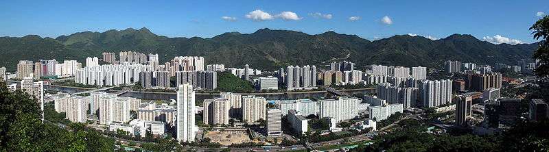
Cityscape
Tourist attractions

Local and tourist attractions in the Sha Tin area include, most famously, the Hong Kong Heritage Museum, which is Hong Kong's newest and largest museum. The Museum was opened on 16 December 2000 and includes 12 galleries, a café and museum shop. Other attractions include:
- Sha Tin Racecourse – located in Shatin Town, it is one of the two racecourses in Hong Kong.
- Che Kung Miu
- Tao Fung Shan
- Amah Rock
- Tsang Tai Uk – an 1848 dwelling of granite, timber and green brick, with defence towers and a still-used ancestral hall.
- Lion Pavilion (獅子亭)
- New Town Plaza – a large shopping mall in Sha Tin Town.
- Ten Thousand Buddhas Monastery
- Shing Mun River
- Lion Rock
- Sha Tin Park – a popular park running alongside the Shing Mun river channel (open daily 0700 – 2245) in Sha Tin Town.
- Penfold Park
- Sha Tin Town Hall – the premier cultural venue in the eastern New Territories, hosting cultural events and exhibitions.
- Snoopy's World. Six zones of amusements on the third floor of the New Town Plaza, including Snoopy's House, a canoe ride and a museum of Peanuts characters (open daily, 1000–2200).
See also
References
- ↑ 2011 Population Census Summary Results (PDF), Hong Kong: Census and Statistics Department, 2012, p. 19, retrieved 11 June 2012
- ↑ "District Highlights". Sha Tin District Council. April 2012. Retrieved 11 June 2012.
- ↑ Lill, Coran (2 July 2004). "TTP to build Asian towers". ShareChat.co.nz. Retrieved 11 June 2012.
External links
| Wikimedia Commons has media related to Sha Tin District. |
- Sha Tin District Council
- List and map of electoral constituencies (large PDF file)
- Sha Tin New Town
- Prince of Wales Hospital
- Chinese University of Hong Kong
- Hong Kong Heritage Museum
- Hong Kong Tourist Board's Sha Tin website
 |
Tai Po District | | ||
| Tsuen Wan District | |
|||
| ||||
| | ||||
| Kwai Tsing District Sham Shui Po District |
Kowloon City District, Wong Tai Sin District | Sai Kung District |