Tai Po District
| Tai Po 大埔區 | ||
|---|---|---|
| District | ||
| Tai Po District | ||
|
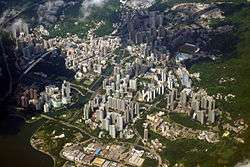
Day view of Tai Po in the Tai Po District | ||
| ||
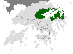 Location of Tai Po District within Hong Kong | ||
| Coordinates: 22°27′03″N 114°09′51″E / 22.45085°N 114.16422°ECoordinates: 22°27′03″N 114°09′51″E / 22.45085°N 114.16422°E | ||
| Country | Hong Kong | |
| Region | New Territories | |
| Constituencies | 19 | |
| Government | ||
| • District Council Chairman | Cheung Hok-ming (DAB) | |
| Area | ||
| • Total | 148.05 km2 (57.16 sq mi) | |
| Population (2006) | ||
| • Total | 293,542 | |
| • Density | 2,000/km2 (5,100/sq mi) | |
| Time zone | Hong Kong Time (UTC+8) | |
| Website | Tai Po District Council | |

| Tai Po District | |||||||||||||||||||
| Traditional Chinese | 大埔區 | ||||||||||||||||||
|---|---|---|---|---|---|---|---|---|---|---|---|---|---|---|---|---|---|---|---|
| Simplified Chinese | 大埔区 | ||||||||||||||||||
| |||||||||||||||||||
.jpg)
Tai Po District (Chinese: 大埔區) is one of the 18 districts of Hong Kong. It covers the areas of Tai Po, Tai Po Kau, Ting Kok, Plover Cove and its exclave is northern part of Sai Kung Peninsula on both shores of Tolo Channel. It is located in the Eastern New Territories. The administrative centre of the district is Tai Po Town (the Tai Po New Town).
Like Yuen Long, the area of Tai Po used to be a traditional market town. Tai Po New Town, developed around the area of Tai Po and on reclaimed land on the estuaries of Lam Tsuen and Tai Po rivers. It had a population of 310,879 in 2001. The district has the third lowest population density.
Geography
Lam Tsuen River Tai Po is located in the north of Hong Kong, northeast of Sha Tin. Even though the Tai Po Industrial Estate is located in the district, it is still one of the most unpolluted districts in Hong Kong. Tai Po's population density is considerably lower than Kowloon's, having many old, small villages in the mountains.
Islands
In addition to the mainland part of the district, the following islands of Hong Kong are under the jurisdiction of Tai Po District:
- A Chau (丫洲, Centre Island)
- Breaker Reef - Tai Po
- Bun Sha Pai (崩紗排)
- Cham Pai (杉排)
- Chau Tsai Kok (洲仔角)
- Che Lei Pai (扯里排)
- Chek Chau (赤洲, Port Island)
- Flat Island (銀洲)
- Hau Tsz Kok Pai (孝子角排)
- Hin Pai (蜆排)
- Kung Chau (弓洲)
- Ma Shi Chau (馬屎洲)
- Ma Yan Pai (媽印排)
- Mo Chau (磨洲)
- Ping Chau (平洲)
- Sam Pui Chau (三杯酒)
- Sha Pai (沙排)
- Shek Ngau Chau (石牛洲)
- Tang Chau (燈洲)
- Tap Mun Chau (塔門洲, Grass Island)
- Tit Shue Pai (鐵樹排)
- Wai Chau Pai (灣仔排)
- Wu Chau (烏洲)
- Yeung Chau (洋洲)
Tai Po FC
Tai Po FC is the first district football team ever to make it to the Hong Kong First Division League among the 19 district football sides from the Hong Kong Third District Division League. The club plays its home games at Tai Po Sports Ground and has since won the 2008-09 Hong Kong FA Cup. See: Tai Po FC
Spa Resort Development
There is plan to develop a spa hotel resort at Ting Kok, near Tai Mei Tuk. The site will occupy 61,000 sq m and has no more than 230 hotel rooms. Tai Po District councilor Yam Kai-Kong admits the benefits from tourism and job opportunities will be good but he is also concerned about the mangroves and increased traffic in the area.[1]
Culture
Hong Kong Note Printing Limited, which prints all the bank notes in Hong Kong, is located in the Tai Po Industrial Estate, an industrial area of light industries (food processing, printing, etc.). Also located in Tai Po:
- The Hong Kong Railway Museum
- The Hong Kong Institute of Education
- Island House
- Tai Po Waterfront Park
- Tai Po Sports Ground
Transport
This district is served by the Tolo Highway, MTR East Rail Line (Tai Po Market and Tai Wo)along with, Ma On Shan Line (Wu Kai Sha)and Tai Po Road. Direct bus routes are available to majority area of Hong Kong. Examples are:
| Destination | Bus route(s) |
|---|---|
| Yuen Long Town | 64K, 264R |
| Tai Po Market MTR Station, Tai Po Town | 71A, 71K, 71S, K12, K14, K17, K18 |
| Fu Heng Estate | 71B |
| Cheung Sha Wan | 72 |
| Kwai Tsing | 272P |
| Sha Tin Town, Tai Po Town | 72A, 73A, N73 |
| Mong Kok | 72X |
| Sheung Shui Town, Fanling Town | 73, 73A, N73 |
| Tsuen Wan Town | 73X, 273C, 273P |
| Kwun Tong | 74A, 74X |
| San Mun Tsai | 74K |
| Tai Mei Tuk | 75K |
| Kowloon City, Lok Fu, Wong Tai Sin | 75X |
| Tsim Sha Tsui | 271, 271P, N271 |
| Hong Kong Science Park | 272K |
| The Hong Kong Institute of Education | 74K |
| Airport | E41, N42A |
| Hong Kong Island | 307, 307A,307B,307C,307P |
References
- ↑ (traditional Chinese (HK))大埔汀角打造水療中心 Oriental Daily. 4 January 2011.
See also
External links
- Tai Po District Council
- List and map of electoral constituencies 1 (large PDF file)
- List and map of electoral constituencies 2 (large PDF file)
- About Tai Po New Town
 |
North District | |
| |
| Yuen Long District | |
South China Sea | ||
| ||||
| | ||||
| Tsuen Wan District | Sha Tin District | Sai Kung District |