Ten Thousand Buddhas Monastery
| Ten Thousand Buddhas Monastery | |||||||||||
 Statues along the stairs leading to the Ten Thousand Buddhas Monastery | |||||||||||
| Traditional Chinese | 萬佛寺 | ||||||||||
|---|---|---|---|---|---|---|---|---|---|---|---|
| |||||||||||
Ten Thousand Buddhas Monastery (Man Fat Tsz) is a Buddhist temple in Sha Tin, Hong Kong. It is located at 220 Pai Tau Village, Sha Tin. It is not an actual monastery as there are no resident monks and is managed by laypersons.
Historic background
In 1951, Venerable Yuet Kai (Chinese: 月溪法師; pinyin: yuè xī), a devout Buddhist layman founded the Monastery,[1] coming to Hong Kong in 1933. He preached Buddhism in a local monastery. He planned to establish a Buddhist college when he accepted an estate from a pious Buddhist who was also a rich merchant. The Ten Thousand Buddhas Monastery was constructed at the beginning of 1949. Despite his old age, Yuet Kai carried the buildings materials personally from the foot of the mountain together with his disciples to build the monastery. It took eight years to complete all the buildings and another ten years to finish the 12,800 Buddha statues. Construction was finished in 1957.[2] Today, his preserved body is presented in the main hall of the monastery in a glass case.
The Main Temple and the Pagoda of the Monastery are graded as Grade III Historic Buildings due to their historic significance.[3]

Facilities
The monastery, which occupies over 8 hectares, is made up of two groups of architectural structures at lower and higher levels respectively. There is a pagoda, a hall, two pavilions and a tower in the architectural structure at the lower level. There are four halls in another structure at the higher level.[2]
The five halls in the monastery are used to house the statues of Buddhas.[2]
The main journey up to the monastery is an attraction itself, as the path is lined on both sides with golden Buddhas, each unique and in different poses.
Photos
 Main sanctum
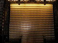 Wall with some of the smaller Buddha statues inside the temple
 View of the Main Plaza
%2C_Man_Fat_Din%2C_Sha_Tin_(Hong_Kong).jpg) Main shrine and the courtyard of the Ten Thousand Buddhas Monastery
Main shrine and the courtyard of the Ten Thousand Buddhas Monastery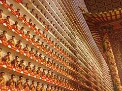 Buddha wall inside temple
See also
References
- ↑ DeWolf, Christopher "9 Hong Kong tourist traps - for better or worse" CNN Go. 27 October 2010. Retrieved 2012-03-03
- 1 2 3 Film Service Office:Ten Thousand Buddhas Monastery
- ↑ List of the 1,444 Historic Buildings in Building Assessment (as of 24 October 2014)
External links
| Wikimedia Commons has media related to Ten Thousand Buddhas Monastery. |
- Monastery's website
- Photo gallery, by Thomas Willig
- Image gallery
- Journey to Ten Thousand Buddhas Monastery video
- "Ten Thousand Buddhas Monastery", at nextstophongkong.com
Coordinates: 22°23′15.29″N 114°11′5.33″E / 22.3875806°N 114.1848139°E