Sarangani, Davao Occidental
For the province, see Sarangani.
| Sarangani | |
|---|---|
| Municipality | |
|
Nickname(s): The Paradise of the South; Southern Island of the Philippines; Gateway to Southern Philippines; Hot Springs Capital of Davao Occidental | |
| Motto: " Sarangani Bayan Natin, Sarangani Paraiso Natin! " | |
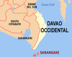 Map of Davao Occidental with Sarangani highlighted | |
.svg.png) Sarangani Location within the Philippines | |
| Coordinates: 05°24′N 125°28′E / 5.400°N 125.467°ECoordinates: 05°24′N 125°28′E / 5.400°N 125.467°E | |
| Country | Philippines |
| Region | Davao Region (Region XI) |
| Province | Davao Occidental |
| District | Lone District of Davao Occidental |
| Founded | 1980 |
| Barangays | 12 |
| Government[1] | |
| • Mayor | Jerry T. Cawa |
| Area[2] | |
| • Total | 97.72 km2 (37.73 sq mi) |
| Population (2010)[3] | |
| • Total | 23,290 |
| • Density | 240/km2 (620/sq mi) |
| Time zone | PST (UTC+8) |
| ZIP code | 8015 |
| Dialing code | +63 (0)82 |
| Income class | 4th |
| Website |
www |
Sarangani is a fourth class municipality in the province of Davao Occidental, Philippines. According to the 2010 census, it has a population of 23,290 people.[3]
The municipality consists of 2 major islands (the eponymous Sarangani Island and Balut Island) and 1 minor islet (Olanivan Island), collectively called as the Sarangani Islands, located just south of Mindanao island in the Celebes Sea.
Barangays
Sarangani is politically subdivided into 12 barangays.[2]
- Batuganding
- Konel
- Lipol
- Mabila (Poblacion)
- Tinina
- Gomtago
- Tagen
- Tucal
- Patuco (Sarangani Norte) (includes Olanivan islet)
- Laker (Sarangani Sur)
- Camahual
- Camalig
Demographics

Map of the Sarangani islands
| Population census of Sarangani | ||
|---|---|---|
| Year | Pop. | ±% p.a. |
| 1990 | 15,003 | — |
| 1995 | 16,648 | +1.97% |
| 2000 | 18,391 | +2.16% |
| 2007 | 20,394 | +1.44% |
| 2010 | 23,290 | +4.95% |
| Source: National Statistics Office[3] | ||
Local government
Municipal officials 2013-2016:[1]
- Mayor: Virginia Cawa
- Vice-Mayor: Jerry Cawa
- Councilors:
- Alfredo Lora
- Sergio Tablingon
- Adelan de Arce
- Jamere Ismael
- Lorencio Angin
- Windy Grace Gomez
- Jovanie Amierol
- Arturo Olarte, Jr.
References
- 1 2 "Official City/Municipal 2013 Election Results". Intramuros, Manila, Philippines: Commission on Elections (COMELEC). 1 July 2013. Retrieved 5 September 2013.
- 1 2 "Province: Davao Occidental". PSGC Interactive. Makati City, Philippines: National Statistical Coordination Board. Retrieved 12 May 2014.
- 1 2 3 "Total Population by Province, City, Municipality and Barangay: as of May 1, 2010" (PDF). 2010 Census of Population and Housing. National Statistics Office. Retrieved 12 May 2014.
External links
- Philippine Standard Geographic Code
- Philippine Census Information
- Local Governance Performance Management System
 |
Jose Abad Santos Sarangani Strait |
| ||
| Celebes Sea | |
Philippine Sea | ||
| ||||
| | ||||
| Celebes Sea |
This article is issued from Wikipedia - version of the 11/13/2016. The text is available under the Creative Commons Attribution/Share Alike but additional terms may apply for the media files.