Saline Township, Cooper County, Missouri
| Saline Township | |
|---|---|
| Township | |
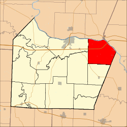 Location in Cooper County | |
| Coordinates: 38°54′22″N 92°34′22″W / 38.90611°N 92.57278°WCoordinates: 38°54′22″N 92°34′22″W / 38.90611°N 92.57278°W | |
| Country |
|
| State |
|
| County | Cooper |
| Area | |
| • Total | 47.94 sq mi (124.16 km2) |
| • Land | 46.71 sq mi (120.98 km2) |
| • Water | 1.23 sq mi (3.18 km2) 2.56% |
| Elevation | 581 ft (177 m) |
| Population (2000) | |
| • Total | 687 |
| • Density | 14.7/sq mi (5.7/km2) |
| Time zone | CST (UTC-6) |
| • Summer (DST) | CDT (UTC-5) |
| ZIP codes | 65068, 65233, 65287 |
| GNIS feature ID | 0766538 |
Saline Township is one of fourteen townships in Cooper County, Missouri, USA. As of the 2000 census, its population was 687.[1]
Saline Township most likely takes its name from Petite Saline Creek.[2]
Geography
According to the United States Census Bureau, Saline Township covers an area of 47.94 square miles (124.16 square kilometers); of this, 46.71 square miles (120.98 square kilometers, 97.44 percent) is land and 1.23 square miles (3.18 square kilometers, 2.56 percent) is water.
Cities, towns, villages
Unincorporated towns
- Overton at 38°56′52″N 92°34′35″W / 38.947811°N 92.576296°W
- Pleasant Grove at 38°52′07″N 92°33′07″W / 38.868643°N 92.551854°W
(This list is based on USGS data and may include former settlements.)
Adjacent townships
- Moniteau Township, Howard County (north)
- Katy Township, Boone County (northeast)
- Linn Township, Moniteau County (southeast)
- Prairie Home Township (south)
- Clark Fork Township (southwest)
- Boonville Township (west)
Major highways
School districts
- Boonville School District
- Prairie Home R-V School District
Political districts
- Missouri's 6th congressional district
- State House District 117
- State Senate District 21
References
- United States Census Bureau 2008 TIGER/Line Shapefiles
- United States Board on Geographic Names (GNIS)
- United States National Atlas
- ↑ United States Census Bureau American FactFinder
- ↑ "Cooper County Place Names, 1928–1945 (archived)". The State Historical Society of Missouri. Retrieved 24 September 2016.
External links
 |
Moniteau Township, Howard County | Katy Township, Boone County | | |
| Boonville Township | |
|||
| ||||
| | ||||
| Clark Fork Township | Prairie Home Township | Linn Township, Moniteau County |
Municipalities and communities of Cooper County, Missouri, United States | ||
|---|---|---|
| Cities | 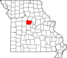 | |
| Villages | ||
| Townships | ||
| Unincorporated communities | ||
This article is issued from Wikipedia - version of the 9/24/2016. The text is available under the Creative Commons Attribution/Share Alike but additional terms may apply for the media files.