Roselands, New South Wales
| Roselands Sydney, New South Wales | |||||||||||||
|---|---|---|---|---|---|---|---|---|---|---|---|---|---|
 King Georges Road, Roselands Shopping Centre entrance | |||||||||||||
| Coordinates | 33°55′54″S 151°05′07″E / 33.93166°S 151.08514°ECoordinates: 33°55′54″S 151°05′07″E / 33.93166°S 151.08514°E | ||||||||||||
| Population | 11,167 (2011 census)[1] | ||||||||||||
| Established | 1987 | ||||||||||||
| Postcode(s) | 2196 | ||||||||||||
| Location | 16 km (10 mi) SW of Sydney CBD | ||||||||||||
| LGA(s) | Canterbury-Bankstown Council | ||||||||||||
| State electorate(s) | |||||||||||||
| Federal Division(s) | Watson | ||||||||||||
| |||||||||||||

Roselands is a suburb in south-western Sydney, in the state of New South Wales, Australia. Roselands is located 16 kilometres south-west of the Sydney central business district in the Canterbury-Bankstown Council.
Geography
Roselands lies in the Cooks River watershed. The soil is clay, based on Wianamatta shale and is on the eastern edge of the great Cumberland Plain which extends westward to the Hawkesbury River and into the Blue Mountains. The topography is low rolling hills. Before settlement, the vegetation was open eucalypt woodland.
History
Aboriginal
The first inhabitants of surrounding areas were Australian Aboriginals who arrived about 40,000 years ago. At the time of British settlement in 1788 the inhabitants were Aborigines of the Darug language group and they called themselves Kuri or Koori. Land grants by the new colonial government began in about 1810.
European
This area was originally part of the suburb of Punchbowl and still shares it's postcode of 2196. H.R. Morgan was granted land in the area in 1842. John Fenwick bought 100 acres (0.40 km2) in about 1880 from Matthew Norman in the area between Canterbury, Canarys and Bonds Roads. He built Belmore House on this land, which was demolished for the construction of the Roselands Shopping Centre. The closest railway line was built to the neighbouring suburb of Belmore in 1895 and extended to Bankstown in 1909.
The suburb takes its name from the plant nursery that originally occupied the land. Later a golf course was built with same name which was taken over to build the shopping centre. It became a suburb on 9 February 1987, after some years of agitation by local residents and members of parliament.[2]
Commercial area
Roselands Shopping Centre was the third fully enclosed shopping precinct in Australia, opened in October 1965 (predated by Monaro Mall [March 1963] in Canberra and Miranda Fair [March 1964] in Sydney). Older open-air shopping precincts in Australia included Chermside Drive-in Shopping Centre [May 1957] in Brisbane, Top Ryde Drive-in Shopping Centre [November 1957] in Sydney, Chadstone Shopping Centre [October 1960] in Melbourne and Warringah Mall [April 1963] in Sydney.
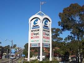
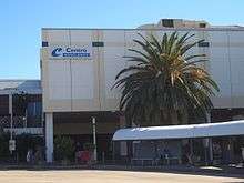
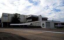
Roselands was built on the site of a golf course. It boasted a large Grace Bros Department Store (now Myer), a single movie cinema, an indoor rainfall water feature (the 'raindrop fountain'), tennis courts and the first food court in Australia (Four Corners, demolished in 2000, remade as the Raindrop Food Court in December 2000). Many local bus services were diverted to service the new shopping centre upon its opening, but the centre was primarily designed for the age of the automobile with plenty of parking as being distant from any railway stations. It has since had many upgrades although it remains smaller than other Sydney shopping centres. It is currently owned and operated by Vicinity Centres. It currently features a large 3 floor Myer store, Target, Coles, Food For Less, JB Hi-Fi, a large Food Court with many Specialty stores.
Transport
King Georges Road is the main road through Roselands. It is a ring road which connects the northern suburbs of Sydney and the north coast motorways of New South Wales to the southern beaches of Sydney and the south coast motorways of New South Wales. King Georges Road also connects Roselands to the M5 South Western Motorway which links to Sydney's International Airport (15 minutes drive east) and west to Canberra and Melbourne.
Sport and recreation
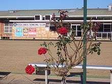
The Lantern Club is located in Roselands Avenue. Roselands Aquatic Centre is located in Centre Avenue, opposite the shopping centre. Roselands soccer club is located at Bennett Park.
Population
According to the 2001 Census, 35.1 per cent of Roselands residents (3,467 persons) stated they had been born overseas. This is higher than the Australian average of 23.1 per cent but considerably less than in the adjacent suburb of Lakemba where over two-thirds of the population were born overseas. Lebanon was the birthplace of the most foreign-born residents in Roselands at 5.1 per cent (509 persons), followed by those born in Greece at 4.0 per cent (397) and those born in the People's Republic of China at 2.7 per cent (266 persons).
In terms of ethnicity, the largest group in 2001 were those claiming "Australian" ancestry with 15.4 per cent of the responses or 1,749 persons, followed by those claiming English background at 14.6 per cent or 1,656 persons, and thirdly by those claiming Greek descent with 13.3 per cent or 1,505 persons.
Census data reveal that English only is the most common home language in Roselands, used by a plurality of 42.9 per cent of residents (4,273 persons), followed by Greek — the home language of 13.6 per cent (1,353 persons) — and Arabic spoken by 13.5 per cent at home (1,349 persons). The English language was spoken exclusively or "very well" or "well" by 80.6 per cent of the suburb's overseas-born in 2001.
According to the census, Christianity was the most followed faith in Roselands with 69.2 per cent of residents reporting that they were Christian (6,898 persons). However, Christians in the area belong to many sects, with the largest proportions being Catholic at 28.8 per cent or 2,874 persons, Orthodox with 17.8 per cent or 1,773 persons, and Anglican with 12.0 per cent or 1,200 persons. Islam is the fourth largest religious group, accounting for 11.4 per cent of residents or 1,139 persons. The census does not differentiate between Sunni and Shi'a.
Politics
Roselands is in the state electorates of Lakemba and Canterbury, both of which are safe Labor seats.
References
- ↑ Australian Bureau of Statistics (31 October 2012). "Roselands (State Suburb)". 2011 Census QuickStats. Retrieved 19 April 2015.
- ↑ http://www.canterburycommons.net/index.php?title=Roselands_NSW History of Canterbury suburbs - Roselands
External links
| Wikimedia Commons has media related to Roselands, New South Wales. |