Beverley Park, New South Wales
| Beverley Park Sydney, New South Wales | |||||||||||||
|---|---|---|---|---|---|---|---|---|---|---|---|---|---|
 St George Leagues Club | |||||||||||||
| Population | 2,053 (2011 census)[1] | ||||||||||||
| Postcode(s) | 2217 | ||||||||||||
| Location | 15 km (9 mi) south of Sydney CBD | ||||||||||||
| LGA(s) | Georges River Council | ||||||||||||
| State electorate(s) | Rockdale | ||||||||||||
| Federal Division(s) | Cook | ||||||||||||
| |||||||||||||
Beverley Park is a suburb in southern Sydney, in the state of New South Wales, Australia. Beverley Park is located 15 kilometres south of the Sydney central business district, in the Georges River Council and is part of the St George area.
Beverley Park is surrounded by the suburbs Kogarah Bay, Carlton, Kogarah, Ramsgate and Sans Souci. It is a predominantly residential area around a large recreational area, Beverley Park Golf Course. It has a few commercial developments scattered along its borders on the Princes Highway and Rocky Point Road.
History
Beverley Park and Kogarah Bay were originally part of the suburb of Kogarah. The area had been originally known as Townson's Bay and then Koggorah.[2] Kogarah and Kogarah Bay were completely separated from each other by the creation of this new suburb. The suburb took its name from the large recreational park, which includes the Beverley Park Golf Course.
Sunnyside is a historic sandstone house on the corner of Princes Highway and Lacey Street, which was originally the home of Patrick J. Lacey, an early mayor of Kogarah Municipality, a Church of England rectory in 1930s and a private kindergarten and primary school from 1948. It was sold in 1958 and converted into a rooming house until 1993 when it became a private residence again.
Population
According to the 2011 census of Population, there were 2,103 people usually resident in Beverley Park. 34.9% of residents stated they were born overseas with the top countries of birth being Greece 5.0%, China 3.4% and England 2.0%. English was stated as the only language spoken at home by 52.9% of residents and the most common other languages spoken were Greek 18.6%, Arabic 4.4% and Cantonese 3.2%. The most common responses for religious affiliation were Catholic 30.8%, Orthodox 27.2% and Anglican 11.7%.[1]
Sport and recreation
The St George Leagues Club is located on Princes Highway. Beverley Park Golf Club covers a large percentage of this suburb's area.
-

Beverley Park Golf Course
-
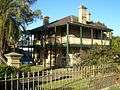
Sunnyside, Princes Highway
References
- 1 2 Australian Bureau of Statistics (31 October 2012). "Beverley Park (State Suburb)". 2011 Census QuickStats. Retrieved 29 April 2013.
- ↑ "Archived copy". Archived from the original on 20 June 2008. Retrieved 2008-06-20. St George Leader
External links
- Alison Grellis (2008). "Beverley Park". Dictionary of Sydney. Retrieved 25 September 2015. [CC-By-SA]
Coordinates: 33°58′44″S 151°07′43″E / 33.97897°S 151.12850°E