Red Line (Jerusalem Light Rail)
| Red Line (Jerusalem Light Rail) הרכבת הקלה בירושלים | |||||||||||||||||||||||||||||||||||||||||||||||||||||||||||||||||||||||||||||||||||||||||||||||||||||||||||||||||||||||||||||||||||||||||||||||||||||||||||||||||||||||||||||||||||||||||||||||||||||||||||||||||||||||||||||||||||||||
|---|---|---|---|---|---|---|---|---|---|---|---|---|---|---|---|---|---|---|---|---|---|---|---|---|---|---|---|---|---|---|---|---|---|---|---|---|---|---|---|---|---|---|---|---|---|---|---|---|---|---|---|---|---|---|---|---|---|---|---|---|---|---|---|---|---|---|---|---|---|---|---|---|---|---|---|---|---|---|---|---|---|---|---|---|---|---|---|---|---|---|---|---|---|---|---|---|---|---|---|---|---|---|---|---|---|---|---|---|---|---|---|---|---|---|---|---|---|---|---|---|---|---|---|---|---|---|---|---|---|---|---|---|---|---|---|---|---|---|---|---|---|---|---|---|---|---|---|---|---|---|---|---|---|---|---|---|---|---|---|---|---|---|---|---|---|---|---|---|---|---|---|---|---|---|---|---|---|---|---|---|---|---|---|---|---|---|---|---|---|---|---|---|---|---|---|---|---|---|---|---|---|---|---|---|---|---|---|---|---|---|---|---|---|---|---|---|---|---|---|---|---|---|---|---|---|---|---|---|---|---|---|
|
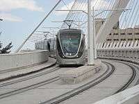
Light Rail on Chords Bridge | |||||||||||||||||||||||||||||||||||||||||||||||||||||||||||||||||||||||||||||||||||||||||||||||||||||||||||||||||||||||||||||||||||||||||||||||||||||||||||||||||||||||||||||||||||||||||||||||||||||||||||||||||||||||||||||||||||||||
| Overview | |||||||||||||||||||||||||||||||||||||||||||||||||||||||||||||||||||||||||||||||||||||||||||||||||||||||||||||||||||||||||||||||||||||||||||||||||||||||||||||||||||||||||||||||||||||||||||||||||||||||||||||||||||||||||||||||||||||||
| Type | Tram | ||||||||||||||||||||||||||||||||||||||||||||||||||||||||||||||||||||||||||||||||||||||||||||||||||||||||||||||||||||||||||||||||||||||||||||||||||||||||||||||||||||||||||||||||||||||||||||||||||||||||||||||||||||||||||||||||||||||
| Status | Opened | ||||||||||||||||||||||||||||||||||||||||||||||||||||||||||||||||||||||||||||||||||||||||||||||||||||||||||||||||||||||||||||||||||||||||||||||||||||||||||||||||||||||||||||||||||||||||||||||||||||||||||||||||||||||||||||||||||||||
| Locale | Jerusalem | ||||||||||||||||||||||||||||||||||||||||||||||||||||||||||||||||||||||||||||||||||||||||||||||||||||||||||||||||||||||||||||||||||||||||||||||||||||||||||||||||||||||||||||||||||||||||||||||||||||||||||||||||||||||||||||||||||||||
| Termini |
Israel Air Force Street Mount Herzl | ||||||||||||||||||||||||||||||||||||||||||||||||||||||||||||||||||||||||||||||||||||||||||||||||||||||||||||||||||||||||||||||||||||||||||||||||||||||||||||||||||||||||||||||||||||||||||||||||||||||||||||||||||||||||||||||||||||||
| Stations | 23 | ||||||||||||||||||||||||||||||||||||||||||||||||||||||||||||||||||||||||||||||||||||||||||||||||||||||||||||||||||||||||||||||||||||||||||||||||||||||||||||||||||||||||||||||||||||||||||||||||||||||||||||||||||||||||||||||||||||||
| Services | 1 (Pisgat Ze'ev – Mount Herzl) | ||||||||||||||||||||||||||||||||||||||||||||||||||||||||||||||||||||||||||||||||||||||||||||||||||||||||||||||||||||||||||||||||||||||||||||||||||||||||||||||||||||||||||||||||||||||||||||||||||||||||||||||||||||||||||||||||||||||
| Daily ridership | 130,000 (2013)[1] | ||||||||||||||||||||||||||||||||||||||||||||||||||||||||||||||||||||||||||||||||||||||||||||||||||||||||||||||||||||||||||||||||||||||||||||||||||||||||||||||||||||||||||||||||||||||||||||||||||||||||||||||||||||||||||||||||||||||
| Website | www.citypass.co.il | ||||||||||||||||||||||||||||||||||||||||||||||||||||||||||||||||||||||||||||||||||||||||||||||||||||||||||||||||||||||||||||||||||||||||||||||||||||||||||||||||||||||||||||||||||||||||||||||||||||||||||||||||||||||||||||||||||||||
| Operation | |||||||||||||||||||||||||||||||||||||||||||||||||||||||||||||||||||||||||||||||||||||||||||||||||||||||||||||||||||||||||||||||||||||||||||||||||||||||||||||||||||||||||||||||||||||||||||||||||||||||||||||||||||||||||||||||||||||||
| Opened |
August 19, 2011 (free trial service) December 1, 2011 (full revenue service) | ||||||||||||||||||||||||||||||||||||||||||||||||||||||||||||||||||||||||||||||||||||||||||||||||||||||||||||||||||||||||||||||||||||||||||||||||||||||||||||||||||||||||||||||||||||||||||||||||||||||||||||||||||||||||||||||||||||||
| Owner | CityPass Consortium | ||||||||||||||||||||||||||||||||||||||||||||||||||||||||||||||||||||||||||||||||||||||||||||||||||||||||||||||||||||||||||||||||||||||||||||||||||||||||||||||||||||||||||||||||||||||||||||||||||||||||||||||||||||||||||||||||||||||
| Operator(s) | CityPass | ||||||||||||||||||||||||||||||||||||||||||||||||||||||||||||||||||||||||||||||||||||||||||||||||||||||||||||||||||||||||||||||||||||||||||||||||||||||||||||||||||||||||||||||||||||||||||||||||||||||||||||||||||||||||||||||||||||||
| Depot(s) | French Hill depot | ||||||||||||||||||||||||||||||||||||||||||||||||||||||||||||||||||||||||||||||||||||||||||||||||||||||||||||||||||||||||||||||||||||||||||||||||||||||||||||||||||||||||||||||||||||||||||||||||||||||||||||||||||||||||||||||||||||||
| Rolling stock | Alstom Citadis 302 | ||||||||||||||||||||||||||||||||||||||||||||||||||||||||||||||||||||||||||||||||||||||||||||||||||||||||||||||||||||||||||||||||||||||||||||||||||||||||||||||||||||||||||||||||||||||||||||||||||||||||||||||||||||||||||||||||||||||
| Technical | |||||||||||||||||||||||||||||||||||||||||||||||||||||||||||||||||||||||||||||||||||||||||||||||||||||||||||||||||||||||||||||||||||||||||||||||||||||||||||||||||||||||||||||||||||||||||||||||||||||||||||||||||||||||||||||||||||||||
| Line length | 13.8 km (8.6 mi)[2] | ||||||||||||||||||||||||||||||||||||||||||||||||||||||||||||||||||||||||||||||||||||||||||||||||||||||||||||||||||||||||||||||||||||||||||||||||||||||||||||||||||||||||||||||||||||||||||||||||||||||||||||||||||||||||||||||||||||||
| Number of tracks | 2 | ||||||||||||||||||||||||||||||||||||||||||||||||||||||||||||||||||||||||||||||||||||||||||||||||||||||||||||||||||||||||||||||||||||||||||||||||||||||||||||||||||||||||||||||||||||||||||||||||||||||||||||||||||||||||||||||||||||||
| Track gauge | 1,435 mm (4 ft 8 1⁄2 in) standard gauge | ||||||||||||||||||||||||||||||||||||||||||||||||||||||||||||||||||||||||||||||||||||||||||||||||||||||||||||||||||||||||||||||||||||||||||||||||||||||||||||||||||||||||||||||||||||||||||||||||||||||||||||||||||||||||||||||||||||||
| Electrification | 750 V DC OHLE | ||||||||||||||||||||||||||||||||||||||||||||||||||||||||||||||||||||||||||||||||||||||||||||||||||||||||||||||||||||||||||||||||||||||||||||||||||||||||||||||||||||||||||||||||||||||||||||||||||||||||||||||||||||||||||||||||||||||
| Operating speed | 50 km/h (31 mph) maximum | ||||||||||||||||||||||||||||||||||||||||||||||||||||||||||||||||||||||||||||||||||||||||||||||||||||||||||||||||||||||||||||||||||||||||||||||||||||||||||||||||||||||||||||||||||||||||||||||||||||||||||||||||||||||||||||||||||||||
| |||||||||||||||||||||||||||||||||||||||||||||||||||||||||||||||||||||||||||||||||||||||||||||||||||||||||||||||||||||||||||||||||||||||||||||||||||||||||||||||||||||||||||||||||||||||||||||||||||||||||||||||||||||||||||||||||||||||
The red line is the first section in operation of the tram system in Jerusalem, known as Jerusalem Light Rail. It became fully operational on December 1, 2011. The line is 13.9 kilometers (8.6 mi) long with 23 stops. Extensions to the red line are currently under construction to the northern suburb of Neve Yaakov and to Hadassah Ein Kerem Hospital to the southwest. When completed in 2016, these will extend the line's length to 22.5 km.[3]
With a total estimated cost for the initial line of 3.8 billion NIS (approx. US $1.1 billion),[4][5] the project was criticized for budget overruns, for its route serving Jewish neighborhoods in east Jerusalem and for contributing to air and noise pollution during construction.[6]
Red Line Stations
| Station[10][11] | Street | Location | Neighborhood |
|---|---|---|---|
| Mount Herzl Hebrew: הר הרצל |
Herzl Boulevard | Corner of HaPisga Street | Bayit VeGan |
| Yefeh Nof Hebrew: יפה נוף |
Corner of Shmuel Bait Street | Beit HaKerem | |
| Denia Square Hebrew: כיכר דניה |
Corner of HaArazim Street at Denia Square | ||
| He-'Haluts Hebrew: החלוץ |
Corner of HeHaluts Street | ||
| Kiryat Moshe Hebrew: קריית משה |
Corner of HaRav Zvi Yehuda Street | Kiryat Moshe | |
| Central Station Hebrew: התחנה המרכזית |
Jaffa Road | Across from Central Bus Station | Romema[12] |
| Ha-Turim Hebrew: הטורים |
Near Nordau Street | Mahane Yehuda | |
| Mahane Yehuda Hebrew: מחנה יהודה |
Near Mahane Yehuda Market | ||
| Ha-Davidka Hebrew: ה"דביד'קה" |
Corner of Street of the Prophets at Davidka Square | City Center | |
| Jaffa – Center Hebrew: יפו – מרכז |
Corner of King George and Straus Streets | ||
| City Hall Hebrew: העיריה |
Near Safra Square | ||
| Damascus Gate Hebrew: שער שכם |
Heil HaHandassa Street | Corner of Sultan Suleiman Street | |
| Shivtei Israel Hebrew: שבטי ישראל |
Corner of Shivtei Israel Street | Beit Yisrael | |
| Shim'on Ha-Tsadik Hebrew: שמעון הצדיק |
Haim Bar Lev Boulevard | Corner of Shimon HaTsadik Street | Sheikh Jarrah |
| Ammunition Hill Hebrew: גבעת התחמושת |
Corner of Levi Eshkol Boulevard | French Hill | |
| Giv'at Ha-Mivtar Hebrew: גבעת המיבתר |
Shuafat Road | Corner of Sheshet HaYamim Street | Givat HaMivtar |
| Es-Sahl Hebrew: א-סהל |
Corner of Umm Al-Amed Street | Shuafat | |
| Shu'afat Hebrew: שועפאט |
Corner of Ben Rabah Street | ||
| Beit 'Hanina Hebrew: בית חנינא |
Yekutiel Adam Street | Corner of Beit Hanina Street | Beit Hanina |
| Yekuti'el Adam Hebrew: יקותיאל אדם |
Corner of Moshe Dayan Boulevard | Pisgat Ze'ev | |
| Pisgat Ze'ev Center Hebrew: פסגת זאב מרכז |
Moshe Dayan Boulevard | Near Hapisga Mall | |
| Sayeret Dukhifat Hebrew: סיירת דוכיפת |
Corner of Sayeret Dukhifat Street | ||
| 'Heil Ha-Avir Hebrew: חיל האויר |
Corner of Heil HaAvir Street |
Extension plans
Initial extensions to the Red Line were planned to the neighborhoods of Neve Yaakov in northern East Jerusalem and Ein Karem (near Hadassah Hospital) in the southwest. Former mayor Uri Lupolianski stated that they would be completed at the same time as the rest of the line. In 2008, French company Egis Rail won an 11.9 million Euro contract to carry out some of the design work. However, in March 2009, CityPass turned down implementing the project.[13] In May 2010 the Jerusalem Municipality announced that the extensions would be built by the state authorities rather than a private company. The extension to Hadassah Hospital from Mount Herzl is particularly challenging and will involve a complex path with complicated bridging works. As of summer 2012, while works on the extension have not begun, the line's final terminal station, next to Hadassah's new inpatient building is nevertheless being built during the construction of the inpatient building – in order not to disrupt hospital operations later after the new building will be completed.[3] Also planned are branches to the Red Line that would create a "campus line" connecting the Mount Scopus and Givat Ram campuses of the Hebrew University.[14]
See also
References
- ↑ Gilran, Eldar (2013-08-20). "CityPass Will Pay NIS 1 Million in Fines for Delays". Israel Army Radio.
- ↑ "Jerusalem Light Rail Project". Railway Technology. Retrieved 2008-11-22.
- 1 2 "Extending Light Rail to Hadassa Ein Kerem" (Press release) (in Hebrew). Jerusalem Municipality. July 12, 2012. Retrieved September 9, 2012.
- ↑ Melanie Lidman (2011-06-30). "Capital merchants struggle with endless light rail delays". The Jerusalem Post. Retrieved 2011-07-04.
- ↑ Hasson, Nir (2011-04-02). "Light Rail on the Way". Haaretz (in Hebrew). Retrieved 2011-04-02.
- ↑ "Findings of the London session, 20-22 November 2010" (PDF). Russell Tribunal on Palestine. Retrieved 2011-12-30.
- ↑ "Jerusalem Green Map: Public Transportation". Green Map. p. 1. Retrieved 14 August 2015.
- ↑ "Jerusalem Green Map: Public Transportation". Green Map. p. 2. Retrieved 14 August 2015.
- ↑ "Jerusalem Green Map: Public Transportation". Green Map. p. 3. Retrieved 14 August 2015.
- ↑ "Jerusalem Light Rail line map" (PDF). CityPass. Retrieved 14 August 2015.
- ↑ "Jerusalem Light Rail line map" (PDF) (in Hebrew). CityPass. Retrieved 14 August 2015.
- ↑ "Jerusalem Neighborhoods: Romema". Jerusalem Municipality. 2 February 2014. Retrieved 14 August 2015.
- ↑ Bar-Gil, Doron (March 8, 2009). "CityPass Canceled Light Rail Works in Neve Ya'akov and Ein Kerem" (in Hebrew). nrg Maariv. Retrieved 2009-03-10.
- ↑ Friedman, Ron (May 25, 2010). "Jerusalem Presents New Transport Plan". The Jerusalem Post. Retrieved 2014-09-16.