Givat Ram
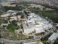

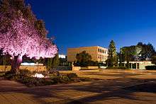
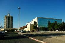
Givat Ram (Hebrew: גִּבְעַת רָם) is a neighborhood in central Jerusalem. Many of Israel's most important national institutions are located in Givat Ram, among them the Parliament (Knesset), the Israel Museum (as well as the private Bible Lands Museum), the Supreme Court, Bank of Israel, Academy of the Hebrew Language, National Library, one of the campuses of the Hebrew University of Jerusalem, and many government ministries' offices.
Etymology
Ram is a Hebrew acronym for Rikuz Mefakdim – Hebrew: גבעת ריכוז-מפקדים, lit. officers' assembly, therefore Giv'at Ram means Officers' assembly hill.[1][2]
History
Before 1948, Maps of the area drawn by the Survey of Palestine team tagged it as Karam es Sila,
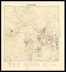
the name indicates it was a Karam (grape field) belonging to Sala (שלה might be originally סלע or سلع) family or the grape field near stone quarries.
Before Israel's War of Independence in 1948, the area in the north was known by the Arabs as Sheikh Badr. In December 1949, the Israeli government headed by David Ben-Gurion, passed a resolution to build a government precinct in Jerusalem. Givat Ram, a hill in the west of the city, which had been an assembly point for the Gadna Youth Battalions, was chosen for this purpose. The topography of the site, made up of three ridges, meshed with the idea of establishing three clusters of buildings – the government precinct, a university campus and a museum.[3]
The Knesset, Israeli government offices and the Israeli Supreme Court are located in Givat Ram, as are cultural landmarks such as the Israel Museum, the Bible Lands Museum,[4] the Bloomfield Science Museum, a campus of the Hebrew University of Jerusalem,[5] the National Library of Israel,[6] and the Binyanei HaUma convention center.
The northern part of the neighborhood, between the convention center and the university, where the government ministries are clustered, is officially known as Kiryat HaLeom. A new apartment project, Mishkenot Ha’uma, is being built in this area.[7] The Wohl Rose Garden is also located in the neighborhood.
Archaeological findings
The first salvage excavation was conducted before Binyanei HaUma was built, in July- August 1949, by M. Avi-Yonah, who unearthed hewn installations, cisterns and pools of various sizes dating to the Herodian period, bricks and tiles bearing stamps of the Tenth Roman Legion, and the remains of a monastery.
In May–June 1968, before a new hotel (then the Hilton) was built south of Binyanei HaUma, Avi-Yonah conducted a second salvage excavation. He found remains of an oval-shaped potter's kiln, a preparation area for clay, and a deep water cistern. The area had been covered by a thick layer of plaster upon which were found large mortaria and many bricks, some bearing stamps of the Tenth Legion.
During the work on a new international convention center east of Binyanei HaUma, a large salvage excavation was conducted in April–September 1992 on behalf of the Israel Antiquities Authority, but roughly 60% of the parking lot area had already been dug up by bulldozers.
In July 1993, a small excavation in the northwestern corner dismantled kilns of the Tenth Legion and lifted a mosaic floor of the Byzantine period.[8]
See also
References
| Wikimedia Commons has media related to Givat-Ram. |
- ↑ "Yad Ben Zvi website (Hebrew)". Ybz.org.il. Retrieved 2013-01-20.
- ↑ "Jerusalem Municipality website". Jerusalem.muni.il. Retrieved 2013-01-20.
- ↑ http://www.google.com/search?q=givat+ram&hl=en&sourceid=gd&rls=GGLD,GGLD:2006-01,GGLD:en
- ↑ "Jewish Pride: Prime Minister's Son Wins Bible Contest". Israelnationalnews.com. Retrieved 2013-01-20.
- ↑ "International dictionary of university histories: edited by Carol Summerfield and Mary Elizabeth Devine". Books.google.com. Retrieved 2013-01-20.
- ↑ Aryeh Dayan. "New chapter in a sad saga". Haaretz. Retrieved October 1, 2008.
- ↑ Paul Widen (October 22, 2010). "A luxury we can't afford". Jerusalem: The Jerusalem Post. Retrieved 2011-065-13. Check date values in:
|access-date=(help) - ↑ Excavations on the Site of the Jerusalem International Convention Center (Binyanei Ha'uma): Pottery and Other Small Finds, Arubas and Goldfus

Neighborhoods of Jerusalem | ||
|---|---|---|
Jerusalem neighborhoods east of the 1949 armistice line are depicted in green, those west of the line in blue (see Green Line). | ||
| Old City |  | |
| Central Neighborhoods |
| |
| Northern Neighborhoods | ||
| Eastern Neighborhoods | ||
| Southern Neighborhoods | ||
| Western Neighborhoods | ||
| Historical Neighborhoods | ||
| ||
Coordinates: 31°47′N 35°12′E / 31.78°N 35.20°E