Rantzausgade

Rantzausgade is a street in the Nørrebro district of Copenhagen, Denmark. It runs from Åboulevard in the southeast to Jagtvej in the northeast where its name changes to Borups Allé.
History
.jpg)
Rantzausgade was originally called Nordvestvej ("Northwest Road") and only reached as far as Brohusgade where it ended in a wooden fence.[1] Being located within the so-called Demarcation Line which followed Jagtvej, that is on the esplanade (in the original military sense of the word) outside Copenhagen's fortifications, only minor buildings could be built in the area. On the other side of the fence at the far end of the road and on the banks of the Ladegård Canal to the south market gardens, they were particularly known for their production of rhubarb. When the area was built over from the 1870s on, developing into a dense working-class neighbourhood, one of the poorest in Copenhagen, it became known as Rabarberkvarteret ("The Rhubarb Neighbourhood").[2] The term rabarberkvarter has in Danish since developed into a derogatory, generic term for a poor, late 19th or early 20th-century working-class neighbourhood with low housing standards.[2] In 1879, the company Glud & Marstrandm, a manufacturer of metal goods, opened a factory at No. 22–24.

Another extension of Nordvestvej, beyond Jagtvej, began in 1902 but this section was renamed Borups Allé following the death of the politician Ludvig Christian Borup in 1903. The rest of the street was renamed Rantzausgade in 1906 for the Danish-German noble family Rantzau originating in the Duchy of Holstein.
The Nordbanen railway line crossed the street from 1894 on its way from Copenhagen's second central station at Axeltorv to Helsingør. The railway crossing disappeared in 1930 when the Boulevard Line opened.[3] Tram line No. 13 operated through the street from 1915 until 1965 on its way from City Hal Square to Lyngbygade (Now Hillerødgade).[4]
Notable buildings and residents
Prinsesse Thyras Asyl (now Prinsesse Thyras Børnehus) at No. 48 opened as a private kindergarten on 1 January 1878 with Princess Thyra of Denmark as protector. It is now owned by the city.
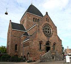
Brorson's Church (No. 49) is from 1901 and was designed by Thorvald Jørgensen, who also designed Christiansborg as well as several other churches in Copenhagen.[5]
.jpg)
The former building of the Regional Archive for Zealand is located in the northern part of the western end of the street, facing Nuuks Plads. The oldest part of the complex is from 1893 and was designed by Martin Nyrop in the National Romantic style. It was expanded by Nils Koppel in the 1960s.
The triangular apartment block located between the Regional Archive Building is called Brohus and is from 1901. It is bounded by Florsgade.
Artworks, memorials and urban design
The artwork Secret Garden (Den hemmelige have) was designed by Morten Stræd in connection with the creation of three new urban spaces between Rantzausgade and the Agade Cycle Bridge in 2011.[6]
Transport
The Nørrebro Route of Copenhagen's network of super bikeways follows the alignment of the abandoned rail line. A bus trap is located at the site where the bikeway crosses Rantzausgade. The street is served by bus lines 12, 18 and 66.[7]
Nuuks Plads at the junction with Jagtvej will be the site of one of the stations on the City Circle Line of the Copenhagen Metro.
Cultural references
In his memoir, En rabarberdreng vokser op ("A Rhubarb Boy Grows Up"), the writer Christian Christensen describes his childhood, growing up in a working-class family living on Nordvestvej.[8]
References
- ↑ "Lidt om gaden" (in Danish). AB Rantzausgade. Retrieved 2014-10-26.
- 1 2 "Rabarberkvarter" (in Danish). Ordbog over det danske Sprog. Retrieved 2014-10-26.
- ↑ "1930" (in Danish). Selskabet or Københavns Histori. Retrieved 2014-10-26.
- ↑ "Københavns Sporveje". vognstyrer.dk. Retrieved 2014-10-26.
- ↑ "Brorsons Kirke" (in Danish). nordenskirker.dk. Retrieved 2011-02-16.
- ↑ "Nørrebros nye byrum er mest til gennemfart". Politiken. Retrieved 2014-10-26.
- ↑ "Ankomster på Rantzausgade (København) (21:35 - 22:35)" (in Danish). Rejseplanen.dk. Retrieved 2014-10-26.
- ↑ "Brohus historie" (in Danish). Ejerforeningen Brohus. Retrieved 2014-10-26.
External links
| Wikimedia Commons has media related to Rantzausgade. |
Coordinates: 55°41′12″N 12°32′56″E / 55.6868°N 12.5488°E