Åboulevard
.JPG)
Åboulevard (lit. "River Boulevard") is a street in central Copenhagen, Denmark. Together with H. C. Andersens Boulevard in the city centre and Borups Allé, it forms a major artery in and out of the city. The road is built over Ladegårds Å, a canal originally built to supply Copenhagen with water, which still runs in a pipe under it, feeding water into Peblinge Lake.
History
.jpg)
.jpg)
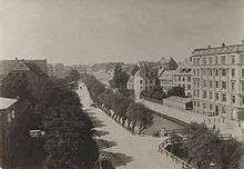
The canal was dug during the late Middle Ages to supply Copenhagen with drinking water from Damhus Lake and from about 1550 also Lundehus Lake. The name Ladegårdså (Ladegårds Å, Ladegårdsåen) originates from Ladegården, a farm under Copenhagen Castle which was located on the south bank of the stream, roughly where the Radio House is today. It was built in 1623 to provide produce for the royal household and feed for the royal mews but was never a success. The complex was later converted into first a military hospice and later a poorhouse with an associated textile manufactory.[1]
A road on the south side of the stream was called Ladegårdsvej ("Ladegård Road") while the north side was called Agade ("River Street"). The lower part of the stream, from Brohusgade to Peblinge Lake, was covered in 1897 to allow for an expansion of the road. Agade was renamed Åboulevard ("River Boulevard") while Ladegårdsvej continued to run parallel to it. Ladegården closed as a poorhouse in 1908 and was replaced by Sundholm on Amager.[2]
Ladegårdsvej disappeared in connection with an expansion of Åboulevard and the rest of the remainder of the stream was covered in 1942. The elevated road Åbuen was built in 1970–72, connecting Åboulevard to Borups Allé.
Notable buildings and residents
.jpg)
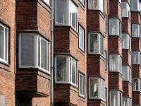
The Functionalist apartment building Trekanten ("The Triangle")on the rounded corner of Åboulevard and Rosenørns Allé was designed by Kay Fisker.[3] In collaboration with C. F. Møller, Fisker also designed the neighbouring housing estate, Hermanhus, which consists of two buildings surrounding a greenspace called Hermann Triers Plads ("Hermann Trier's Square"). The bay windows are typical of his Functionalist style. The buildings were listed in 1981.
The Bethlehem Church (No. 8) was designed by Peder Vilhelm Jensen-Klint and completed by his son Kaare Klint in 1937. The design resembles that of Jensen-Klint's most famous work, the monumental Grundtvig's Church in Bispebjerg.[4] Åhusene ("The River Houses" (No. 14 and 16), two identical apartment buildings situated next to the church, were designed by Ulrik Plesner and are from 1936 to 1938.[5][6]

The Avenue Hotel (No. 29) is a 68-room boutique hotel now part of Brøchner Hotels. The Historicist hotel building was completed in 1898 to design by Emil Blichfeldt who has also designed the main entrance to Tivoli Gardens.[7] Its neighbor, Svaneborg (Mo. 31), situated at the corner with H. C. Ørsteds Vej, was completed in 1899 to design by Philip Smidth.
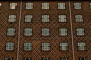
The apartment building at No. 55 at the corner with Bülowsvej is from 1903 and was designed by Heinrich Hansen. Linoleumshuset ("The Linoleum House") No. 84–86) is named for its patterned brickwork resembling old-fashioned linoleum flooring.[8] The building was designed by Povl Baumann and completed in 1930. It was listed in 2010.[9]
Memorial

A pyramidical granite stone in the street side outside No. 16 commemorates an accident that occurred on the night between 26 and 27 November 1812 when a carriage with five women and a boy, on its way from the country house Rolighed into town, fell into the water at Ladegården. Two of the women drowned. Tradition had it that a pointed granite stone was installed in the water at the site of the accident to commemorate the event. The stone is an old water level marker. The stone used to have a no longer readable inscription reading "26&ndash27 November 1812. When Ladegårds Å was filled to create the current Åboulevard, this memorial was installed between the trees on the boulevard at the site where it formerly stood in the water".[10]
The artwork City Wall (Bymuren) is designed by Morte Stræd and was installedin in connection with the creation of three new urban spaces between the Agade Cycle Bridge and Rantzausgade in 2011.[11]
Transport
The Agade Bicycle Bridge was installed in 2009 as part of the Nørrebro Route, a section of Copenhagen's network of super bikeways. The super bikeway uses part of the alignment of the abandoned rail line between Nørrebro station and Copenhagen's second Central Station at Axeltorv on its way from Emdrup in the north to Valby in the south.
Re-opening of the canal
It has been proposed to re-establish the Ladegårdså Canal by placing it on top of a 3-km long car tunnel.[12] The project was put on hold in 2013 after a report from Rambøll deemed it too expensive.[13]
See also
References
- ↑ "Ladegården". Selskabet for Københavns Historie. Retrieved 12 February 2016.
- ↑ "Åboulevard - fra å til indfaldsvej" (in Danish). Berlingske. Retrieved 2014-10-25.
- ↑ "Trekanten" (in Danish). Ejerbolig.nu. Retrieved 2014-10-25.
- ↑ "Bethlehemskirken, København". arkark.dk. Retrieved 2014-10-25.
- ↑ "Åhusene, København". arkark.dk. Retrieved 2014-10-25.
- ↑ "Sag: Åhusene - Åboulevard 015-018, København" (in Danish). Kulturstyrelsen. Retrieved 2014-10-25.
- ↑ "Avenue Hotel". Tablet Hotels. Retrieved 2016-01-06.
- ↑ "Linoleumshuset, København N" (in Danish). arkark.dk. Retrieved 2014-10-25.
- ↑ "Sag: Linoleumshuset" (in Danish). Kulturstyrelsen. Retrieved 2016-01-06.
- ↑ "Ladegårdsåen mellem Blågårdsgade og Ewaldsgade set fra Blågårdsbroen" (in Danish). Museum of Copenhagen. Retrieved 2014-10-25.
- ↑ "Nørrebros nye byrum er mest til gennemfart". Politiken. Retrieved 2014-10-26.
- ↑ "Drøm om å på Åboulevarden får nyt liv" (in Danish). Politiken. Retrieved 2014-10-25.
- ↑ "Planer for åbning af å på Nørrebro er strandedt" (in Danish). Politiken. Retrieved 2014-10-25.
External links
| Wikimedia Commons has media related to Åboulevard. |
Coordinates: 55°41′06″N 12°33′10″E / 55.6850°N 12.5528°E