Röbel
| Röbel | |||
|---|---|---|---|
| |||
 Röbel | |||
Location of Röbel within Mecklenburgische Seenplatte district 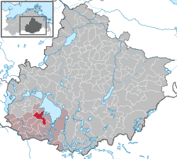 | |||
| Coordinates: 53°22′34″N 12°36′22″E / 53.37611°N 12.60611°ECoordinates: 53°22′34″N 12°36′22″E / 53.37611°N 12.60611°E | |||
| Country | Germany | ||
| State | Mecklenburg-Vorpommern | ||
| District | Mecklenburgische Seenplatte | ||
| Municipal assoc. | Röbel-Müritz | ||
| Government | |||
| • Mayor | Heiner Müller (SPD) | ||
| Area | |||
| • Total | 30.17 km2 (11.65 sq mi) | ||
| Population (2015-12-31)[1] | |||
| • Total | 5,129 | ||
| • Density | 170/km2 (440/sq mi) | ||
| Time zone | CET/CEST (UTC+1/+2) | ||
| Postal codes | 17207 | ||
| Dialling codes | 039931 | ||
| Vehicle registration | MÜR | ||
| Website | http://www.amt-roebel-mueritz.de/ | ||


Lake Müritz in Röbel
Röbel is a municipality in the Mecklenburgische Seenplatte district, in Mecklenburg-Western Pomerania, Germany. It is situated on the western shore of Lake Müritz, 25 km north of Wittstock, and 27 km southwest of Waren. It is part of the Amt Röbel-Müritz.
Sights

Aerial view of Rübel's old town
The museum Engelscher Hof and the half-timbered former synagogue provide a permanent exhibition on Mecklenburg's Jewish history, commemorating - among other things - the life and work of Israel Jacobson, formerly consistorial president in the Kingdom of Westphalia and feudal landlord in Jördenstorf.

Röbel's historical Jewish centre, the synagogue.

Windmill
References
External links
![]() Media related to Röbel/Müritz at Wikimedia Commons
Media related to Röbel/Müritz at Wikimedia Commons
This article is issued from Wikipedia - version of the 11/17/2016. The text is available under the Creative Commons Attribution/Share Alike but additional terms may apply for the media files.