Quilicura
| Quilicura | ||||||
|---|---|---|---|---|---|---|
| City and Commune | ||||||
| ||||||
| Coordinates (city): 33°22′S 70°44′W / 33.367°S 70.733°WCoordinates: 33°22′S 70°44′W / 33.367°S 70.733°W | ||||||
| Country | Chile | |||||
| Region | Santiago | |||||
| Province | Santiago | |||||
| Government[1][2] | ||||||
| • Type | Municipality | |||||
| • Alcalde | Juan Carrasco Contreras (Ind.) | |||||
| Area[3] | ||||||
| • Total | 57.5 km2 (22.2 sq mi) | |||||
| Population (2012 census) | ||||||
| • Total | 203,946[4] | |||||
| Sex (2002 census)[3] | ||||||
| • Men | 62,421 | |||||
| • Women | 64,097 | |||||
| Website | Municipality of Quilicura | |||||

Quilicura (/kɪliˈkʊərə/ KIL-i-KOOR-ə; Spanish pronunciation: [kiliˈkuɾa]) is a commune of Chile located in capital Santiago. Founded in 1901, it is a satellite city on what was originally the outskirts of the city of Santiago, but as urban sprawl has set in it is now quickly urbanizing from what was recently prime agricultural land.
Quilicura is home to many industries and its residents are mostly low-income families, though recent urbanizations have attracted middle class groups.
Etymology
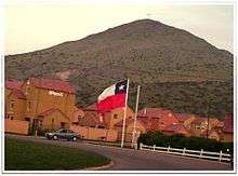
The origin of the name Quilicura is from the Mapuche language Mapudungun and comes from the words kila meaning three and kura meaning stone. The "Three Stones" are three hills which separate the area and formed the border with Renca.
Location
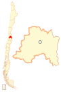
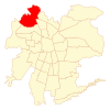
Quilicura is located in Santiago Province, Santiago Metropolitan Region, at the northwestern edge of Chile's capital Santiago. It borders Renca to the south (naturally separated by Renca Hill), Pudahuel to the west, Huechuraba and Conchalí to the east, and Lampa and Colina to the north.
Demographics
According to the 2002 census, Quilicura spans an area of 57.5 km2 (22 sq mi) and has 126,518 inhabitants (62,421 men and 64,097 women). Of these, 125,999 (99.6%) lived in urban areas and 519 (0.4%) in rural areas. The population grew by 207.7% (85,397 persons) between the 1992 and 2002 censuses.[3] According to the 2012 census preliminary data Quilicura is now home to 203,946 residents.[4]
In 2005 the regional quality of life index was rated at a medium level of 72.53 or 34 out of 52. In 2003 Quilicura's Human Development Index was recorded as 0.782 or 19 out of 341.[5]
In 2011 the average annual household per capita income was rated at US$9,302 (PPP).[6][7] The population below the poverty line was 9.9% in 2011.[6]
The ethnic breakdown of the population was 96% white and mestizo (121,815), 3.4% Mapuche (4,346), >1% Aimara (47), >1% Atacameño (40), >1% Quechua (29), >1% Rapanui (25), >1% Alacalufe (10), >1% Yámana (10), >1% Colla (4), as of the 2002 census.[8]
Transport
Quilicura is located about 12 km from Santiago's international airport and is served by the Américo Vespucio Norte Highway as well as the Pan-American Highway. Transantiago public buses connect Quilicura to the centre of Santiago these run frequently in each direction. A subway line connecting the commune with the rest of Santiago's subway network is expected to be completed by 2017-2018. The current metro station that is closest to Quilicura is Vespucio Norte which is on the Yellow line, it can be reached via the 425 bus from Quilicura.
Administration
As a commune, Quilicura is a third-level administrative division of Chile administered by a municipal council, headed by a mayor who is directly-elected every four years. The 2012-2016 mayor is Juan Carrasco Contreras (Ind.).[1][2] The communal council has the following members:
- Mario Alvear Gilberto (RN)
- María Indo Romo (PDC)
- Claudia Donoso Plaza (UDI)
- Jorge Godoy Soto (PRO)
- Víctor Arias González (PC)
- Jaime Aceitón Vásquez (PRO)
- Dino Belmar Dinamarca (PPD)
- Alvaro Guajardo Figueroa (PDC)
Within the electoral divisions of Chile, Quilicura is represented in the Chamber of Deputies by Patricio Melero (UDI) and Gabriel Silber (PDC) as part of the 16th electoral district, (together with Colina, Lampa, Tiltil and Pudahuel). The commune is represented in the Senate by Guido Girardi (PPD) and Jovino Novoa (UDI) as part of the 7th senatorial constituency (Santiago-West).
References
- 1 2 "Asociación Chilena de Municipalidades" (in Spanish). Retrieved 27 January 2011.
- 1 2 "Municipality of Quilicura" (in Spanish). Retrieved 27 January 2011.
- 1 2 3 "National Statistics Institute" (in Spanish). Retrieved 13 December 2010.
- 1 2 "Resultados Preliminares Censo de Población y Vivienda 2012" (PDF) (in Spanish). Instituto Nacional de Estadísticas. 31 August 2012. Note: Data are preliminary.
- ↑ "Las Trayectorias del Desarrollo Humano en las Comunas de Chile (1994-2003) Archived July 7, 2011, at the Wayback Machine.." UNDP, Gobierno de Chile, Mideplán
- 1 2 "Casen Survey 2011". Ministry of Social Development of Chile. 2011.
- ↑ "OECD.StatExtracts". OECD. Retrieved 2012-09-10. Note: Data refer to "PPPP41: Purchasing Power Partities for actual individual consumption." Figure used is 425.368652.
- ↑ "Sistema de Información Regional". Archived from the original on August 23, 2010. Retrieved September 13, 2010.
External links
- (Spanish) Municipality de Quilicura
- (Spanish) Quilicura TV Canal 6 Comunitario
- In Mapudungun