Ptení
| Ptení | |
|---|---|
| Municipality | |
 | |
 Ptení | |
| Coordinates: 49°30′54″N 16°55′55″E / 49.51500°N 16.93194°ECoordinates: 49°30′54″N 16°55′55″E / 49.51500°N 16.93194°E | |
| Country |
|
| Region | Olomouc |
| District | Prostějov |
| Area | |
| • Total | 18.51 km2 (7.15 sq mi) |
| Elevation | 322 m (1,056 ft) |
| Population (2006) | |
| • Total | 1,109 |
| • Density | 60/km2 (160/sq mi) |
| Postal code | 798 03 to 798 43 |
| Website | http://www.pteni.cz |
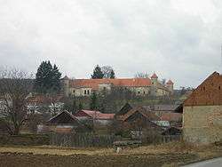
Ptení is a village and municipality (obec) in Prostějov District in the Olomouc Region of the Czech Republic.
The municipality covers an area of 18.51 square kilometres (7.15 sq mi), and has a population of 1,109 (as at 28 August 2006).
Ptení lies approximately 14 kilometres (9 mi) west of Prostějov, 25 km (16 mi) west of Olomouc, and 192 km (119 mi) east of Prague.
References
| Wikimedia Commons has media related to Ptení. |
This article is issued from Wikipedia - version of the 4/7/2016. The text is available under the Creative Commons Attribution/Share Alike but additional terms may apply for the media files.