Powdersville, South Carolina
| Powdersville, South Carolina | |
|---|---|
| Census-designated place | |
|
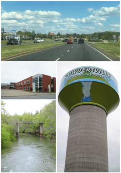
Top, left to right: South Carolina Highway 153, Powdersville High School, Saluda River, Powdersville water tower | |
| Nickname(s): The Ville, Pville | |
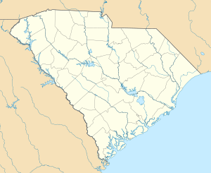 Powdersville Location within the state of South Carolina | |
| Coordinates: 34°46′57″N 82°29′32″W / 34.78250°N 82.49222°WCoordinates: 34°46′57″N 82°29′32″W / 34.78250°N 82.49222°W | |
| Country | United States |
| State | South Carolina |
| County | Anderson |
| Area | |
| • Total | 14.0 sq mi (36.3 km2) |
| • Land | 13.9 sq mi (35.9 km2) |
| • Water | 0.1 sq mi (0.3 km2) |
| Elevation | 971 ft (296 m) |
| Population (2010) | |
| • Total | 7,618 |
| • Density | 549/sq mi (212.0/km2) |
| Time zone | Eastern (EST) (UTC-5) |
| • Summer (DST) | EDT (UTC-4) |
| FIPS code | 45-58165[1] |
| GNIS feature ID | 1250233[2] |
Powdersville is a census-designated place (CDP) in Anderson County, South Carolina, United States. The population was 7,618 at the 2010 census,[3] up from 5,362 at the 2000 census. Powdersville was initially a farming community until the increase in housing subdivisions and businesses along Highway 153.
Geography
Powdersville is located in the northern corner of Anderson County at 34°46′57″N 82°29′32″W / 34.78250°N 82.49222°W (34.782620, -82.492138).[4] Its northwest border is the Pickens County line, and its northeast border is the Saluda River, which forms the Greenville County line. The southeast border of the CDP is formed by Interstate 85, a six-lane highway with access to Powdersville via exits 39 and 40. Greenville, the largest city in the region, is 8 miles (13 km) to the northeast.
According to the United States Census Bureau, the CDP has a total area of 14.0 square miles (36.3 km2), of which 13.9 square miles (35.9 km2) is land and 0.12 square miles (0.3 km2), or 0.90%, is water.
History
The name Powders may have come from a store called Powdersville Area General Store that sold gunpowder. Gunpowder was occasionally found on the ground throughout the area causing people to call it Powdersville. During the American Civil War the area was used to store gunpowder. The Saluda Valley-Powdersville Water Company was created in 1971 to serve drinking water to around 1,200 customers. In 1992 the name changed to Powdersville Water Company and in 2001 the name changed again to Powdersville Water District.[5][6] The first high school in Powdersville was established in 2011 as Powdersville High School.[7]
Demographics
As of the census[1] of 2000, there were 5,362 people, 1,989 households, and 1,615 families residing in the CDP. The population density was 384.4 people per square mile (148.4/km²). There were 2,133 housing units at an average density of 152.9/sq mi (59.0/km²). The racial makeup of the CDP was 94.18% White, 4.35% African American, 0.26% Native American, 0.37% Asian, 0.06% Pacific Islander, 0.21% from other races, and 0.58% from two or more races. Hispanic or Latino of any race were 1.14% of the population.
There were 1,989 households out of which 37.4% had children under the age of 18 living with them, 69.8% were married couples living together, 8.2% had a female householder with no husband present, and 18.8% were non-families. 16.9% of all households were made up of individuals and 5.6% had someone living alone who was 65 years of age or older. The average household size was 2.70 and the average family size was 3.01.
In the CDP the population was spread out with 26.0% under the age of 18, 7.0% from 18 to 24, 30.4% from 25 to 44, 27.2% from 45 to 64, and 9.4% who were 65 years of age or older. The median age was 38 years. For every 100 females there were 95.8 males. For every 100 females age 18 and over, there were 96.1 males.
The median income for a household in the CDP was $50,255, and the median income for a family was $57,131. Males had a median income of $41,297 versus $25,136 for females. The per capita income for the CDP was $20,901. About 2.4% of families and 2.5% of the population were below the poverty line, including 1.1% of those under age 18 and 7.3% of those age 65 or over.
References
- 1 2 "American FactFinder". United States Census Bureau. Retrieved 2008-01-31.
- ↑ "US Board on Geographic Names". United States Geological Survey. 2007-10-25. Retrieved 2008-01-31.
- ↑ "Geographic Identifiers: 2010 Demographic Profile Data (G001): Powdersville CDP, South Carolina". U.S. Census Bureau, American Factfinder. Retrieved August 8, 2013.
- ↑ "US Gazetteer files: 2010, 2000, and 1990". United States Census Bureau. 2011-02-12. Retrieved 2011-04-23.
- ↑ "About Powdersville". Powdersville.com.
- ↑ "History of the Powdersville Water District". powdersvillewaterdistrict.com.
- ↑ "Superintendent's Overview" (PDF). schoolwires.com.
External links
- Powdersville.com, local information
- Powdersville Information Page at SCIway Site
- The Powdersville Post
Municipalities and communities of Anderson County, South Carolina, United States | ||
|---|---|---|
| Cities | 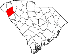 | |
| Towns | ||
| CDPs | ||
| Unincorporated communities | ||
| Footnotes | ‡This populated place also has portions in an adjacent county or counties | |