Pleasant Valley, Carroll County, Arkansas
| Pleasant Valley, Arkansas | |
|---|---|
| Unincorporated community | |
 Pleasant Valley, Arkansas Position in Arkansas | |
| Coordinates: 36°23′13″N 93°36′36″W / 36.38694°N 93.61000°WCoordinates: 36°23′13″N 93°36′36″W / 36.38694°N 93.61000°W | |
| Country |
|
| State |
|
| County | Carroll |
| Township | Prairie |
| Elevation | 373 m (1,224 ft) |
| Time zone | Central (CST) (UTC-6) |
| • Summer (DST) | CDT (UTC-5) |
| GNIS feature ID | 58401 |
| U.S. Geological Survey Geographic Names Information System: Pleasant Valley, Carroll County, Arkansas | |
Pleasant Valley, Arkansas is an unincorporated community in Carroll County, Arkansas, United States.[1] The community is located on Arkansas Highway 143.[2]
References
- ↑ "Feature Detail Report for: Pleasant Valley, Arkansas." USGS. U.S. Geological Survey Geographic Names Information System: Pleasant Valley, Carroll County, Arkansas Retrieved January 9, 2011.
- ↑ Carroll County, Arkansas (PDF) (Map) (2009 ed.). Arkansas State Highway and Transportation Department. Retrieved January 9, 2010.
Municipalities and communities of Carroll County, Arkansas, United States | ||
|---|---|---|
| Cities | 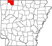 | |
| Towns | ||
| CDP | ||
| Unincorporated communities |
| |
| Ghost towns |
| |
| Townships | ||
| Footnotes | ‡This populated place also has portions in an adjacent county or counties | |
This article is issued from Wikipedia - version of the 2/11/2014. The text is available under the Creative Commons Attribution/Share Alike but additional terms may apply for the media files.