Piru Creek
| Piru Creek | |
| Arroyo de Piruc, Arroyo Piru, Rio Peru | |
| River | |
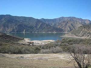 Pyramid Lake, the upper major reservoir on Piru Creek | |
| Country | United States |
|---|---|
| State | California |
| Regions | Ventura County, Los Angeles County |
| Part of | Santa Clara River |
| Tributaries | |
| - left | Sheep Creek (California), Lockwood Creek, Smith Fork Piru Creek, Osito Creek, Ruby Creek (California), Michael Creek |
| - right | Cedar Creek (California), Mutau Creek, Fish Creek (California), Turtle Creek (California), Agua Blanca Creek |
| City | Piru, California |
| Source | San Emigdio Mountains |
| - location | An unnamed spring, Ventura County, United States |
| - elevation | 5,200 ft (1,585 m) |
| - coordinates | 34°38′12″N 119°12′11″W / 34.63667°N 119.20306°W |
| Mouth | Santa Clara River |
| - location | Piru, Ventura County |
| - elevation | 643 ft (196 m) |
| - coordinates | 34°23′56″N 118°47′08″W / 34.39889°N 118.78556°WCoordinates: 34°23′56″N 118°47′08″W / 34.39889°N 118.78556°W |
| Length | 71 mi (114 km) |
| Basin | 497 sq mi (1,287 km2) |
| Discharge | |
| - average | 60.3 cu ft/s (2 m3/s) [1] |
| - max | 35,600 cu ft/s (1,008 m3/s) [2] |
| - min | 0 cu ft/s (0 m3/s) |
Piru Creek is a large stream in northern Los Angeles County and eastern Ventura County, California. It is a tributary of the Santa Clara River, the largest stream system in Southern California that is still relatively natural.
It drains an area of about 497 square miles (1,290 km2) and is about 71 miles (114 km) long.[3] The creek is the Santa Clara's largest tributary, providing about one-half of its flow. Its course is within the Los Padres National Forest, until near it enters Piru Reservoir near its end. There are two major reservoirs on Piru Creek, which provide storage for irrigation and water from the California Aqueduct.
Course
Piru Creek originates as several small springs on the north side of Pine Mountain Ridge (California) of the Santa Ynez Mountains, in the Los Padres National Forest. It flows eastwards through a valley, then south to the confluence with Cedar Creek from the right. After the Cedar Creek confluence the stream turns northeast, receives Sheep Creek from the left, and Mutau Creek on the right. Piru Creek receives Lockwood Creek from the left at Sunset campground on Lockwood Flat, and flows east into a canyon where the valley walls pull in and rise steeper and higher above the river.[4][5]
The Smith Fork of Piru Creek, with headwaters in the San Emigdio Mountains, comes in from the left where the main stem turns sharply southeast, then enters Pyramid Lake reservoir impounded behind Pyramid Dam, which stores imported water from the West Branch California Aqueduct for Ventura County and Los Angeles County. Interstate 5 runs almost a 1,000 feet (300 m) above the reservoir/former canyon on the east side,
Piru Creek, composed of released reservoir water, turns south and flows through Piru Gorge of the Topatopa Mountains and along old route of Hwy 99−Pyramid Dam Road, soon forming the boundary between Mount Pinos and Saugus Ranger Districts of the Los Padres National Forest and dropping over Piru Creek Falls.[4][5][6]
The creek flows south, still along the route of old Hwy 99−Pyramid Dam Road and through Cherry Canyon, to Frenchman's Flat and the confluence with Osito Creek (left). The creek turns sharply to the west entering another gorge, then south through it where it receives from the right Fish Creek of the northeastern Cobblestone Mountain watershed, ephemeral Turtle Creek (right) and Michael Creek (left), and then from the right Agua Blanca Creek of the western and southern Cobblestone Mountain watershed. It crosses the boundary between Los Angeles County and Ventura County five times before leaving the Los Padres National Forest and being impounded behind Santa Felicia Dam in Lake Piru, the second reservoir on the creek.
Downstream of the dam the creek's valley broadens and the creek is allowed to form meanders. It finally exits from Piru Canyon between a pair of ridges just east of the town of Piru, and crosses under California State Route 126. Soon after, its confluence with the Santa Clara River, as a wide gravelly wash river mouth, occurs.[4][5]

History
Thousands of years ago, Native Americans of the Chumash group lived in the area, but by 500 CE, their former territory along Piru Creek had been occupied by the Tataviam. It is believed that there were once up to 25 Native American villages on the river, of which eight have been thoroughly studied. Spanish explorer Don Gaspar first traveled up the creek in 1769.[7] In 1839, the government of Mexico which then held control over Alta California granted the 48,612-acre (19,673 ha) Rancho San Francisco to Antonio del Valle.[8] The Rancho Camulos was created out of Rancho San Francisco land by Ygnacio del Valle in 1853, and included much of the Santa Clara River and Piru Creek Valleys.[9]
In 1842, traces of gold were found on a tributary of the Santa Clara River, Placerita Creek, which joins the main stem about 10 miles (16 km) upstream of Piru.[8] Bn the late 19th century, prospectors discovered traces of calcite on Piru Creek in Lockwood Valley near Frazier Mountain, north of present-day Pyramid Lake. A town called Lexington was platted near the site in 1887 but never actually materialized. Ironically, the real mineral of value in the region turned out to be borax, which was mined in the 1880s by the Frazier Borate Company.[10]
The company town, Stauffer, was established on the Piru in time, and by 1905 had grown to such a size that a post office was set up in the town, which finally was abandoned in 1942 because of dwindling profits from borax mining.[10] The Russell Borate Mining Company also acquired land in the region in 1907 between a pair of earlier excavations. By 1912, the Russell mine was the only one left in operation. Ultimately, all the mines were abandoned because of competitions from borax operations in Death Valley.[11]
Recreation
Hiking, camping, off-roading and rock climbing are some of the recreational opportunities in the Los Padres National Forest that surrounds much of the Piru's course.
One well-known trail follows Piru Creek through the lower part of Piru Gorge from Frenchman's Flat to the confluence with Fish Creek,[12] and it is possible to continue all the way south from there to Lake Piru with much scrambling and wading.[13] The entire hike can require more than two days to complete, and flooding from Piru Creek is a potential danger.[14][15]
In the spring, the stretches of Piru Creek from Pyramid Lake to Lake Piru and from Santa Felicia Dam to the mouth are actually possible to raft and kayak. The 15-mile (24 km) first stretch has rapids up to Class IV and includes the challenging section known as Falls Gorge,[16] while the calmer 4-mile (6.4 km) second reach has Class I-II rapids only.[17] Controlled water releases from the two dams provide some regulation of the flow although an effort is made to simulate natural discharges. As a result, the section is usually only runnable after rainfall.[18] From 0.5 miles (0.80 km) downstream of Pyramid Dam to the Los Angeles-Ventura County line, Piru Creek in various sections is designated a National Wild and Scenic River.[19]
Fishing
At one time fishing along Piru Creek was a year-round activity. In the present day, the uppermost limit of natural fish spawning in the creek is below Pyramid Dam, where a cement culvert adjoining the remains of Highway 99 creates a 15-foot (4.6 m) waterfall.
Piru Creek was once a popular spot for both fly fishing and bait-casting anglers as it contained both wild and hatchery-raised rainbow trout, along with largemouth bass. The creek is no longer stocked with trout by the California Department of Fish and Game [20] and, due to lack of enforcement from the California Department of Fish and Game,[21] frequent poaching of fish from the creek has reduced both the trout and bass population.[22]
Certain spots, posted as “catch and release” areas and restricted to fishing with barbless, artificial lures, are still somewhat active along a three-mile stretch of the creek from Pyramid Dam to Frenchman’s Flat with the best conditions for fishing from January to April (limit of 5 fish per angler). The 900-foot (270 m) reach from Pyramid Dam to a small bridge downstream is closed to any fishing.
See also
- Sespe Creek — watershed on the west.
- Sespe Wilderness
- Santa Clara River topics
References
- ↑ "USGS Gage#11110000 on Piru Creek near Piru (average discharge records)". National Water Information System. United States Geological Survey. 1913–1974. Retrieved 2010-04-08.
- ↑ "USGS Gage#11110000 on Piru Creek near Piru (peak discharge data)". National Water Information System. United States Geological Survey. 1933–1974. Retrieved 2010-04-08.
- ↑ U.S. Geological Survey. National Hydrography Dataset high-resolution flowline data. The National Map. Retrieved 2011-03-16.
- 1 2 3 United States Geological Survey. "United States Geological Survey Topographic Maps". TopoQuest. Retrieved 2010-03-28.
- 1 2 3 USGS Topo Maps for United States (Map). Cartography by United States Geological Survey. ACME Mapper. Retrieved 2010-03-28.
- ↑ "The Definitive Guide to the Waterfalls of Southern and Central California", Chris Shaffer, 1997; ISBN 0971281424.
- ↑ McIntosh, Ann; Ricketts, Conrad (2002). Trout Fishing Near American Cities. Stackpole Books. p. 329. ISBN 0-8117-2958-3. Retrieved 2014-04-08.
- 1 2 Worden, Leon (1996-01-24). "The real story of California's first gold discovery". Santa Clarita Valley History in Pictures. Retrieved 2010-04-10.
- ↑ Triem, Judith P.; Stone, Mitch (1996). "Rancho Camulos: National register of Historic Places Nomination". San Buenaventura Research Associates. Santa Clarita Valley History in Pictures. Retrieved 2010-04-10.
- 1 2 Massey, Peter; Wilson, Jeanne (2006). Backcountry Adventures Southern California: The Ultimate Guide to the Backcountry for Anyone with a Sport Utility Vehicle. Adler Publishing. pp. 225–26. ISBN 1-930193-26-2. Retrieved 2014-04-08.
- ↑ Evans, James R.; Vredenburgh, Larry M. (1982). "Colemanite Deposits near Stauffer, Ventura County, California". History of Mojave Desert Mining. vredenburgh.org. Retrieved 2010-04-10.
- ↑ Brennen, Christopher Earls. "Hike K4: Piru Gorge". Adventure Hikes and Canyoneering in the Southwest. Retrieved 2010-04-10.
- ↑ "Piru Creek". Community Hiking Club. Retrieved 2010-04-10.
- ↑ Schad, Jerry (2007-11-15). "Remote Piru Creek, in the Los Padres National Forest north of Los Angeles, offers a challenging wilderness experience.". San Diego Reader. Retrieved 2010-04-10.
- ↑ Schad, Jerry (2009). Afoot & Afield Los Angeles County: A Comprehensive Hiking Guide (3 ed.). WIlderness Press. ISBN 0-89997-499-6. Retrieved 2014-04-08.
- ↑ "California whitewater - Piru Creek, Pyramid Lake to Lake Piru". RiverFacts. Retrieved 2010-04-10.
- ↑ "California whitewater - Piru Creek, Lake Piru to Santa Clara River". RiverFacts. Retrieved 2010-04-10.
- ↑ "Piru Creek - Pyramid Lake to Lake Piru (Middle Piru)". American Whitewater. Retrieved 2010-04-10.
- ↑ "Piru Creek, California". National Wild and Scenic Rivers. 2010-03-05. Retrieved 2010-04-10.
- ↑ "Pre-Stocking Evaluations - Public Water". California Department of Fish and Game. Retrieved 2012-05-29.
- ↑ "California game wardens are few and far between". California Fish and Game Wardens Association. Retrieved 2012-05-29.
- ↑ "Habitat: Piru Creek". The Ecological Angler. Retrieved 2012-05-29.
External links
| Wikimedia Commons has media related to |
- California Department of Water Resources: Piru Creek
- Friends of the River.org: Piru Creek
- Lake-piru.org: Lake Piru reservoir
- Southern California Coastal Watershed Inventory