Parinacochas Province
| Parinacochas | |
|---|---|
| Province | |
|
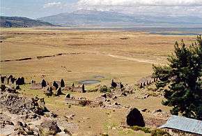
The archaeological site of Inkawasi with the volcano Sara Sara and the lake Parinaqucha in the background | |
 Location of Parinacochas in the Ayacucho Region | |
| Country | Peru |
| Region | Ayacucho |
| Capital | Coracora |
| Area | |
| • Total | 5,968.32 km2 (2,304.38 sq mi) |
| Population (2002) | |
| • Total | 24,028 |
| • Density | 4.0/km2 (10/sq mi) |
The Parinacochas Province is a province located in the Ayacucho Region of Peru. It is one of the eleven that make up that region. The province has a population of 24,028 inhabitants as of 2002. The capital of the province is Coracora.
Boundaries
- North: Apurímac Region
- East: Paucar del Sara Sara Province
- South: Arequipa Region
- West: Lucanas Province
Geography
The highest mountain in the province is Sara Sara at 5,505 m (18,061 ft) on the border to the Paucar del Sara Sara Province. Other mountains are listed below:[1]
- Allqa Q'awa
- Anta P'unqu
- Apachitayuq
- Aqu Q'asa
- Chachakuma
- Challwa Q'asa
- Chawpi Urqu
- Chuku Chuku
- Chunta
- Hatun Qiwuña
- Iskay Pata
- Kiswar
- Kiswarniyuq
- Kuntur Qhata
- Kunturi
- Kunturillu
- Lunq'u
- Maranniyuq
- Millu
- Milluni
- Pilluni
- Pirqa
- Pirwa
- Pisqa Pukyu
- Puka Kunka
- Puka Mach'ay
- Puka Punchu
- Puka Puka
- Puka Ranra
- Puka Saywa
- Pukaqucha
- Pumawiri
- Phiruru
- Qiwña Urqu
- Qullpa Pampa
- Qullqata
- Quriwiri
- Qhata Urqu
- Q'ara Pukyu
- Q'illu
- Q'illu Q'asa
- Q'illu Urqu (Luc.-Par.)
- Q'illu Urqu (Par.)
- Ranrayuq
- Silla Q'asa
- Suparawra
- Uqhu Sinqa
- Wachwani
- Waman Pirqa
- Wamanqucha
- Wamanripa
- Wayunka
- Yana Mach'ay
- Yana Qaqa
- Yana Saya
- Yana Urqu
- Yaritayuq
- Yuraq Phiruru
- Yuraq Q'asa
Political division
The province extends over an area of 5,968.32 square kilometres (2,304.38 sq mi) and is divided into eight districts:
Ethnic groups
The people in the province are mainly indigenous citizens of Quechua descent. Quechua is the language which the majority of the population (54.94%) learnt to speak in childhood, 44.60% of the residents started speaking using the Spanish language (2007 Peru Census).[2]
See also
Sources
- ↑ escale.minedu.gob.pe - UGEL map of the Parinacochas Province (Ayacucho Region)
- ↑ inei.gob.pe INEI, Peru, Censos Nacionales 2007
| |
|---|---|
Coordinates: 15°01′01″S 73°46′50″W / 15.016994°S 73.780419°W