Huanca Sancos Province
| Huanca Sancos | |
|---|---|
| Province | |
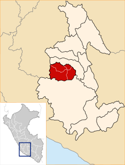 Location of Huanca Sancos in the Ayacucho Region | |
| Country | Peru |
| Region | Ayacucho |
| Capital | Huanca Sancos |
| Government | |
| • Mayor | Cirilo Pacheco Vilchez |
| Area | |
| • Total | 2,862.33 km2 (1,105.15 sq mi) |
| Elevation | 3,408 m (11,181 ft) |
| Population | |
| • Total | 12,120 |
| • Density | 4.2/km2 (11/sq mi) |
| UBIGEO | 0503 |
Huanca Sancos is a province in central Ayacucho, Peru. On April 3, 1983, Shining Path rebels entered the town of Lucanamarca and killed 69 people.
Geography
Some of the highest mountains of the province are listed below:[1]
- Allqa Wasi
- Aqu Chupa
- Aqu Muqu
- Aqu Q'asa
- Atuq Wachanan
- Aya Mach'ay
- Challwana
- Chawpi Urqu
- Chuqllu
- Chuntani
- Chupa Urqu
- Hatun Kinwa
- Hatun Pampa
- Hatun Ranra
- Hatun Saywa
- Hatun Waraqu
- Inka Wasi
- Inti Watana
- Killa Q'asa
- Kiswar
- Kuntur Qaqa
- Kuntur Sinqa
- Kuntur Wasi
- Kunturillu
- K'ichki Qaqa
- Lluqsiyuq
- Machu
- Millpuq
- Millpuq Urqu
- Minasniyuq Urqu
- Misa Rumi
- Ninalla Urqu
- Pampa Mach'ay
- Parya
- Pata Wasi
- Pichu Q'asa
- Pirwalla
- Puka Kancha
- Puka P'unqu
- Puka Qaqa
- Puka Saywa
- Puka Urqu
- Puma Ranra
- Puywanniyuq
- Phiruru
- P'isqu Pallana
- P'ukru Wasi
- Qaqa Wasi
- Qillqalla Q'asa
- Qiwllaqucha
- Qiwllari
- Qucha Wasi
- Qullpa
- Q'asa Wasi
- Q'illu Q'asa
- Q'illu Urqu
- Q'iru Chuku
- Titanka
- Titankayuq
- Urqu Pata
- Urqunqucha
- Usnu
- Wachu Wasi
- Wank'a Saywa
- Wansu
- Waraqu
- Waylla Q'asa
- Waylla Urqu
- Wayra Pata
- Wayta Wayta
- Waytaqucha
- Wichinka Pata
- Wisk'acha Rumi
- Wisk'achayuq
- Yana Kusma
- Yana Q'asa
- Yana Uqsha
- Yana Urqu
- Yanawaqra
- Yuraq Mach'ay
- Yuraq Urqu
Political division
The province extends over an area of 2,862.33 square kilometres (1,105.15 sq mi) and is divided into four districts.
- Sancos (Huanca Sancos)
- Carapo (Carapo)
- Sacsamarca (Sacsamarca)
- Santiago de Lucanamarca (Lucanamarca)
Ethnic groups
The people in the province are mainly indigenous citizens of Quechua descent. Quechua is the language which the majority of the population (80.79%) learnt to speak in childhood, while 18.72% of the residents started speaking using the Spanish language (2007 Peru Census).[2]
See also
Sources
- ↑ escale.minedu.gob.pe - UGEL map of the Huanca Sancos Province (Ayacucho Region)
- ↑ inei.gob.pe INEI, Peru, Censos Nacionales 2007
External links
| |
|---|---|
Coordinates: 13°55′07″S 74°19′55″W / 13.91861°S 74.33194°W
This article is issued from Wikipedia - version of the 6/4/2016. The text is available under the Creative Commons Attribution/Share Alike but additional terms may apply for the media files.