Paikgachha Upazila
| Paikgachha পাইকগাছা | |
|---|---|
| Upazila | |
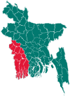
 Paikgachha Location in Bangladesh | |
| Coordinates: 22°35.3′N 89°20.2′E / 22.5883°N 89.3367°ECoordinates: 22°35.3′N 89°20.2′E / 22.5883°N 89.3367°E | |
| Country |
|
| Division | Khulna Division |
| District | Khulna District |
| Government | |
| • Political Leader | Rahmatulla dadu vi,Principal Ruhul Quddus MP,Advocate S.M. Babor Ali M.P, K.M Arifuzzaman Tuhin |
| Area | |
| • Total | 411.19 km2 (158.76 sq mi) |
| Population (1991) | |
| • Total | 225,085 |
| • Density | 550/km2 (1,400/sq mi) |
| Time zone | BST (UTC+6) |
| Website | Official Map of Paikgachha |
Paikgachha (Bengali: পাইকগাছা) is an Upazila of Khulna District[1] in the Division of Khulna, Bangladesh.
Geography
Paikgachha is located at 22°35′20″N 89°20′10″E / 22.5889°N 89.3361°E . It has 41194 households and total area 411.19 km².
Demographics
As of the 1991 Bangladesh census, Paikgachha has a population of 225085. Males constitute 51.14% of the population, and females 48.86%. This Upazila's eighteen up population is 117629. Paikgachha has an average literacy rate of 32.6% (7+ years), and the national average of 32.4% literate.[2]
Administration
Paikgachha has 10 Unions/Wards, 172 Mauzas/Mahallas, and 212 villages.
Kharia, Kharia Lebu-bunia
Transport
Paikgachha Bridge connects Paikgachha with its south part and Koyra Upazilla successfully.
Education
Secondary school
- Paikgachha Govt. Boys School
- Kharia High School, Kharia, Paikgacha
- Kharia Nabarun High School, Kharia, Paikgacha
- Lakshmikhola High School
- Paikgachha Govt. Girls School
- Chandkhali Multilateral Secondary School
- Haridhali Union Secondary School
- PTD Technical and Vocational School
- Kapilmuni Sahachari Vidya Mandir.
College
- Paikgachha College
- Chandkhali College
- Fasiar Rahman Women's College, Paikgachha
- Alomtala Sinior Fazil Madrasah
- Gojalia Kalua Alim Madrasah
- Kapilmuni Sahachary Vidya mandir school & college
- Kapilmuni College
- Haridhali Kapilmuni Mohila College
Notable residents
- Prafulla Chandra Ray - Bengali chemist, educator and entrepreneur
- Qazi Imdadul Haq - Bangladeshi writer
- Meher Musolli
See also
References
- ↑ Ashraful Islam Goldar (2012), "Paikgachha Upazila", in Sirajul Islam and Ahmed A. Jamal, Banglapedia: National Encyclopedia of Bangladesh (Second ed.), Asiatic Society of Bangladesh
- ↑ "Population Census Wing, BBS.". Archived from the original on 2005-03-27. Retrieved November 10, 2006.
| Upazila/Thana: | ||
|---|---|---|
This article is issued from Wikipedia - version of the 11/1/2016. The text is available under the Creative Commons Attribution/Share Alike but additional terms may apply for the media files.