Keshabpur Upazila
| Keshabpur কেশবপুর | |
|---|---|
| Upazila | |
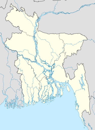 Keshabpur Location in Bangladesh | |
| Coordinates: 22°54.3′N 89°34′E / 22.9050°N 89.567°ECoordinates: 22°54.3′N 89°34′E / 22.9050°N 89.567°E | |
| Country |
|
| Division | Khulna Division |
| District | Jessore District |
| Area | |
| • Total | 258.53 km2 (99.82 sq mi) |
| Population (1991) | |
| • Total | 200,229 |
| • Density | 770/km2 (2,000/sq mi) |
| Time zone | BST (UTC+6) |
| Website | Official Map of Keshabpur |
Keshabpur (Bengali: কেশবপুর) is an Upazila of Jessore District in the Division of Khulna, Bangladesh.
Geography
Keshabpur is located at 22°54′15″N 89°34′00″E / 22.9042°N 89.5667°E. It has 37,513 individual households and a total area of 258.53 km². The distance from Jessore City is 32 km.
Demographics
According of the 1991 Bangladesh census, Keshabpur had a population of 200,229. Males constituted 51.16% of the population, and females 48.84%. This Upazila's population aged 18 or over was 103,794. Keshabpur has an average literacy rate of 55.5% (in those aged seven and above), while the national average is 68.4%.
Points of interest
Sagardari is a village in the Keshabpur Upazila, built on the bank of the Kopotakho River, where the poet Michael Madhusudan Dutt was born on the 25 January 1824. Tourists from all over the world visit "Modhu Palli" and "Modhu Mela", a fair in memory of Modhusudan's Birthday, is held every year.
Archaeological heritage and relics include remnants of the Bharatvhainabazar Rajbari ( Vhani Family-দেউলটি গুপ্ত যুগের খ্রিষ্টীয় ২য় শতকে নির্মিত হয়েছে বলে অনুমান করা হয় ), the residence of Nawab Mir Jumla (17th century), the residence of poet Madhusudan Dutt at Sagardari, and remnants of an ancient fort at village Bidhyanandikathi.
There is a memorial to the War of Liberation.
Administration
Keshabpur Upazila (jessore district) has an area of 258.53 km2 and is bounded by Manipampur upazila to the north, Tala and Dumuria upazilas to the south, Dumuria upazila to the east, and Kalaroa upazila to the west. The main rivers are Harthar and Chengral; Beels 20.
Keshabpur (Town) consists of seven mouzas. The area of the town is 18.46 km². The town has a population of 20,697; male 50.88%, female 49.12%. Population density is 1121 per km2. The literacy rate within the town is 32.9%.
Keshabpur thana was turned into an upazila in 1983. It consists of 9 union parishads, 142 mouzas and 143 villages.
Population 200,229; male 51.16%, female 48.84%; Muslim 80.14%, Hindu 19.5% and others 0.36%.
Education
Literacy and educational institutions Average literacy 31.7%; male 33.5% and female 29.8%. Educational institutions: college 5, high school 32, madrasa 97, government primary school 70, non-government primary school 85. Noted educational institutions: Keshabpur Degree College (1967), Keshabpur Pilot Collegiate School, Keshabpur Girls' School, Panjia High School,Panjia Degree College, Biddyanandkati Rasbihari Institution, Narayanpur High School,Batikhula Dakil Madrasha, Batikhula primary School.
References
| Upazila/Thana: | ||
|---|---|---|