Osceola, West Virginia
| Osceola | |
|---|---|
| Unincorporated community | |
|
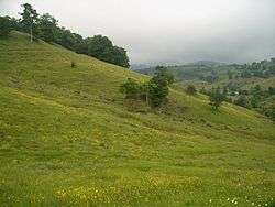
Wildflowers add a splash of color to grazing fields near Osceola, West Virginia in July 2006 | |
 Osceola  Osceola Location within the state of West Virginia | |
| Coordinates: 38°42′50″N 79°38′00″W / 38.71389°N 79.63333°WCoordinates: 38°42′50″N 79°38′00″W / 38.71389°N 79.63333°W | |
| Country | United States |
| State | West Virginia |
| County | Randolph |
| Time zone | Eastern (EST) (UTC-5) |
| • Summer (DST) | EDT (UTC-4) |
Osceola is a former logging community in eastern Randolph County, West Virginia, USA. It was located within what is now the Monongahela National Forest on Gandy Creek at the southern extremity of Little Middle Mountain and Yokum Knob.
The community was named after Osceola, a Seminole chief.[1]
During the period 1900 to 1915, Osceola was a sizable lumbering town of several hundred loggers, timbermen, sawmill operators and saloonkeepers who made the most of the then booming timber industry.[2] Today, virtually no trace of the former settlement is evident. A few scattered hunting camps and farmhouses occupy the area.
Osceola was very near the celebrated Sinks of Gandy Creek and modern maps as often designate the place as “The Sinks”.
References
- ↑ Kenny, Hamill (1945). West Virginia Place Names: Their Origin and Meaning, Including the Nomenclature of the Streams and Mountains. Piedmont, WV: The Place Name Press. p. 463.
- ↑ Preble, Jack, Land of Canaan: Plain Tales from the Mountains of West Virginia, Parsons, West Virginia: McClain Printing Company, 1st ed., 1960; 2nd ed., 1965, 3rd ed., 1971, pg 82.
Municipalities and communities of Randolph County, West Virginia, United States | ||
|---|---|---|
| City | 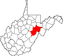 | |
| Towns | ||
| CDPs | ||
| Unincorporated communities |
| |
| Ghost towns | ||
| Footnotes | ‡This populated place also has portions in an adjacent county or counties | |