Ornaisons
| Ornaisons | ||
|---|---|---|
|
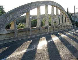
Bridge over the Aussou | ||
| ||
 Ornaisons | ||
|
Location within Occitanie region  Ornaisons | ||
| Coordinates: 43°10′54″N 2°50′17″E / 43.1817°N 2.8381°ECoordinates: 43°10′54″N 2°50′17″E / 43.1817°N 2.8381°E | ||
| Country | France | |
| Region | Occitanie | |
| Department | Aude | |
| Arrondissement | Narbonne | |
| Canton | Lézignan-Corbières | |
| Intercommunality | Région Lézignanaise | |
| Government | ||
| • Mayor (2014) | Gilles Casty | |
| Area1 | 10.8 km2 (4.2 sq mi) | |
| Population (2008)2 | 1,203 | |
| • Density | 110/km2 (290/sq mi) | |
| Time zone | CET (UTC+1) | |
| • Summer (DST) | CEST (UTC+2) | |
| INSEE/Postal code | 11267 / 11200 | |
| Elevation |
27–163 m (89–535 ft) (avg. 35 m or 115 ft) | |
|
1 French Land Register data, which excludes lakes, ponds, glaciers > 1 km² (0.386 sq mi or 247 acres) and river estuaries. 2 Population without double counting: residents of multiple communes (e.g., students and military personnel) only counted once. | ||
.svg.png)
Ornaisons is a commune in the Aude department in southern France.
Geography
The village lies mainly on the left bank of the brook of Aussou, a tributary of the Orbieu, which forms part of the commune's western border, then flows northeast through its northern part.
Population
| Historical population | ||
|---|---|---|
| Year | Pop. | ±% |
| 1962 | 896 | — |
| 1968 | 929 | +3.7% |
| 1975 | 902 | −2.9% |
| 1982 | 903 | +0.1% |
| 1990 | 943 | +4.4% |
| 1999 | 951 | +0.8% |
| 2008 | 1,203 | +26.5% |
See also
References
| Wikimedia Commons has media related to Ornaisons. |
This article is issued from Wikipedia - version of the 7/16/2016. The text is available under the Creative Commons Attribution/Share Alike but additional terms may apply for the media files.