Sigean
| Sigean | ||
|---|---|---|
|
Facade of L.A.C Lieu d'Art Contemporain, housed in a former winery | ||
| ||
 Sigean | ||
|
Location within Occitanie region  Sigean | ||
| Coordinates: 43°01′45″N 2°58′42″E / 43.0292°N 2.9783°ECoordinates: 43°01′45″N 2°58′42″E / 43.0292°N 2.9783°E | ||
| Country | France | |
| Region | Occitanie | |
| Department | Aude | |
| Arrondissement | Narbonne | |
| Canton | Sigean | |
| Intercommunality | Corbières en Méditerranée | |
| Government | ||
| • Mayor (2014–present) | Michel Jammes | |
| Area1 | 35.35 km2 (13.65 sq mi) | |
| Population (2008)2 | 5,163 | |
| • Density | 150/km2 (380/sq mi) | |
| Time zone | CET (UTC+1) | |
| • Summer (DST) | CEST (UTC+2) | |
| INSEE/Postal code | 11379 / 11130 | |
| Elevation |
0–126 m (0–413 ft) (avg. 17 m or 56 ft) | |
| Website |
www | |
|
1 French Land Register data, which excludes lakes, ponds, glaciers > 1 km² (0.386 sq mi or 247 acres) and river estuaries. 2 Population without double counting: residents of multiple communes (e.g., students and military personnel) only counted once. | ||
.svg.png)
Sigean (Occitan Sijan) is a commune in the Aude department in southern France. It formerly lay on Route nationale 9 between Narbonne and Perpignan,[1] but RN 9 (downgraded to route départementale 6009) now bypasses the town of Sigean and is itself bypassed by the A9 autoroute.
Population
| Historical population | ||
|---|---|---|
| Year | Pop. | ±% |
| 1962 | 2,555 | — |
| 1968 | 3,033 | +18.7% |
| 1975 | 3,027 | −0.2% |
| 1982 | 3,058 | +1.0% |
| 1990 | 3,373 | +10.3% |
| 1999 | 4,049 | +20.0% |
| 2008 | 5,163 | +27.5% |
Culture
- The Musée des Corbières in Sigean is a museum dedicated to history and archaeology.[2]
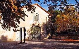
- The L.A.C Lieu d'Art Contemporain, located in Hameau du lac, hosts arts exhibition and performances in a former winery.[3]
- The Zoo Réserve Africaine de Sigean
See also
References
| Wikimedia Commons has media related to Sigean. |
This article is issued from Wikipedia - version of the 10/23/2016. The text is available under the Creative Commons Attribution/Share Alike but additional terms may apply for the media files.