Ormiston, Queensland
| Ormiston Redland City, Queensland | |||||||||||||
|---|---|---|---|---|---|---|---|---|---|---|---|---|---|
 Wellington Street, 2013 | |||||||||||||
| Population | 5,641 (2011 census)[1] | ||||||||||||
| Postcode(s) | 4160 | ||||||||||||
| Location | 25 km (16 mi) from Brisbane GPO | ||||||||||||
| LGA(s) | Redland City | ||||||||||||
| State electorate(s) | Electoral district of Cleveland | ||||||||||||
| Federal Division(s) | Division of Bowman | ||||||||||||
| |||||||||||||
Ormiston is a suburb in Redland City, Queensland, Australia. It is adjacent to the suburbs of Cleveland and Wellington Point. At the 2011 Australian Census the suburb recorded a population of 5,641.[1]
Ormiston is home to the Redlands Christian Reformed Church and Ormiston House.
History
Pre settlement
The Koobenpul lived on the mainland coastal strip stretching from Talwarrapin (Redland Bay) to the mouth of the Mairwar (Brisbane River), including the area now known as Ormiston. Canoe trees and a bora ring from pre-settlement days still remain along Hilliards creek.[2][3]
Post settlement
Originally part of the township of Cleveland, early industry included a brickworks established by James Maskell on the eastern bank of Hilliards Creek in 1852 and fellmongery (wool scour) owned by a Thomas Blackett Stephens until the early 1860s. Joseph Clark ran cattle on Ormiston from 1855 until he relinquished the lease in 1858.[4]
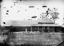
Land around Ormiston was bought in 1853 by Captain Louis Hope, a Scottish aristocrat and a founder of the Queensland sugar industry.[5] Hope built Ormiston House from 1858 and 1865 as the centre of a 325-acre (1.32 km2) sugar estate.[6] Ormiston House is one of the finest examples of colonial architecture in Queensland.[5]

The property was originally called Woojanness, but was renamed Ormiston after the Hope's family ancestral village of Ormiston, Scotland. It has an ornamental garden that dates from the building of the house. Hope continued with his plantation until 1875, until he lost a dispute over access to his sugar mill and decided to dismantle it. Since the 1960s the house has been a museum. Although the house was called Ormiston, the area around it was still known as Cleveland for many years. When the railway came through the area in 1889, the new railway station and the area around it also became known as Ormiston.[7]
Heritage listings

Ormiston has a number of heritage-listed sites, including:
- Sturgeon Street: Ormiston Fellmongery[8]
- Wellington Street: Ormiston House Estate[9]
- Wellington Street: St Andrews Church[10]
Transport
Ormiston railway station provides access to regular Queensland Rail City network services to Brisbane and Cleveland.
Sporting clubs
- Ormiston Redbacks Swim Club - amateur swimming club.
- Redlands Softball League
- Redlands Boxing Club
Schools
- Ormiston College
- Ormiston State School
Demographics
In the 2011 Census the population of Ormiston is 5,641, 52.4% female and 47.6% male.[1] The median/average age of the Ormiston population is 44 years of age, 7 years above the Australian average. 67.3% of people living in Ormiston were born in Australia. The other top responses for country of birth were England 9.9%, New Zealand 5.5%, South Africa 3.3%, Scotland 1.6%, Germany 0.8%. 90.8% of people speak English as their first language 0.7% German, 0.6% Afrikaans, 0.6% Mandarin, 0.5% Italian, 0.3% Greek.[1]
Notable residents
- John Cameron, built and occupied the house Doobawah in Ormiston [11]
- Louis Hope, established the Ormiston Estate [11]
References
- 1 2 3 4 Australian Bureau of Statistics (31 October 2012). "Ormiston (State Suburb)". 2011 Census QuickStats. Retrieved 17 March 2013.
- ↑ Aboriginal cultural heritage Redland City
- ↑ In the beginning Redland City
- ↑ Hilliards Creek History Redland City
- 1 2 Cook, Penny (2006). Discover Queensland Heritage. Corinda, Queensland: Pictorial Press Australia. p. 33. ISBN 1876561424.
- ↑ Captain Hope and Ormiston House, Redland City
- ↑ Ormiston Redland City
- ↑ "Ormiston Fellmongery (entry 700006)". Queensland Heritage Register. Queensland Heritage Council. Retrieved 12 July 2013.
- ↑ "Ormiston House Estate (entry 600775)". Queensland Heritage Register. Queensland Heritage Council. Retrieved 12 July 2013.
- ↑ "St Andrews Church (entry 600774)". Queensland Heritage Register. Queensland Heritage Council. Retrieved 12 July 2013.
- 1 2 "Ormiston timeline". www.redland.qld.gov.au. Retrieved 2015-12-21.
External links
| Wikimedia Commons has media related to Ormiston, Queensland. |
Coordinates: 27°30′43″S 153°15′14″E / 27.512°S 153.254°E