Cleveland, Queensland
| Cleveland Redland City, Queensland | |||||||||||||
|---|---|---|---|---|---|---|---|---|---|---|---|---|---|
 Norfolk Pines in G.J. Walter Park, Cleveland | |||||||||||||
 Cleveland | |||||||||||||
| Coordinates | 27°32′S 153°16′E / 27.533°S 153.267°ECoordinates: 27°32′S 153°16′E / 27.533°S 153.267°E | ||||||||||||
| Population | 14,414 (2011)[1] | ||||||||||||
| • Density | 1,222/km2 (3,164/sq mi) | ||||||||||||
| Established | 1850 | ||||||||||||
| Postcode(s) | 4163 | ||||||||||||
| Area | 11.8 km2 (4.6 sq mi) | ||||||||||||
| Location | 25 km (16 mi) from Brisbane | ||||||||||||
| LGA(s) | Redland City | ||||||||||||
| State electorate(s) | Electoral district of Cleveland | ||||||||||||
| Federal Division(s) | Division of Bowman | ||||||||||||
| |||||||||||||
Cleveland, a suburb of Redland City, is located on the western shores of Moreton Bay approximately 25 kilometres (16 mi) east-south-east of Brisbane, the capital of the Australian state of Queensland. It comprises commercial, residential and industrial areas and is the location of Redland City's Council Chambers, offices and various cultural facilities.
As at the 2011 Census, Cleveland was estimated to be home to 14,414 people, with the majority of these of working age.[1]
History


.jpg)


There are conflicting reports as to the naming of Cleveland; it was either named in 1770 by Captain James Cook in honour of John Clevland, the Secretary of the Admiralty around the time,[2] or by surveyors in the 1840s, in honour of William Vane, 1st Duke of Cleveland.[3]
European settlement of Brisbane and surrounding areas was banned from 1824 until 1842, due to the Moreton Bay Penal Settlement, but the area to become Cleveland was first surveyed in 1840, and in 1841, was recommended for a maritime or seaport township. In 1847 a navigation beacon was established at Cleveland Point.[4]
In 1847, the Government planned for the new town, and on 13 December 1850, Cleveland was proclaimed a township.[5] The first land sales of the new township took place a year later, with early purchases primarily around Cleveland Point, at the time an early candidate for a major port to replace Brisbane. Brisbane was troubled by sand bars across the mouth of the Brisbane River, and Cleveland Point was closer to the southern passage (the entrance to Moreton Bay between North Stradbroke Island and Moreton Island).
However, when Governor Sir George Gipps visited Cleveland in 1842, it is reported that upon disembarking his boat, he immediately sank into the mudflats up to his waist. He was so annoyed by this that he changed his mind and suggested Ipswich.[2][6] A series of wreckings in the southern passage led to ships using the longer but safer northern entrance between Bribie and Moreton islands. This, and an unfortunate fire at the Cleveland jetty, removed any hopes for Cleveland.
In 1852, the first large buildings were built in Cleveland; what is now the Grand View Hotel, and the Old Courthouse, at the time a workers cottage. Farms sprang up; a brickworks was built at the point, and a wool store to handle shipping. The first mail service to Cleveland began in 1861, with the first school established at the same time. The wool store, unused because of Cleveland's failure as a port, was converted into a sawmill, which supplied timber to a shipyard built at the Point. The population at this time was only 270.[5] Tourism blossomed with the arrival of the first regular steamer service to Cleveland in 1864.
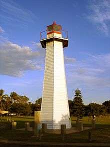
The Cleveland Point Light was also constructed in 1864, and was only replaced in 1969.[2] From this time, the most popular crop was sugar cane, until it was replaced by the popularity of fruits such as passion fruit and strawberries.
A rail line connecting Brisbane to Cleveland was completed in 1889, and with it tourism, residential subdivisions and farming further grew in the area.[3]
The area now known as G.J. Walter Park was originally proclaimed a reserve by the Government on 13 March 1889.[7] This area was used mainly by residents and day trippers for swimming, picnicking and general park use.[8] This area is included on the Redland City Council's Register of Heritage Places classified as being of local significance.[9]
The rail line continued further than it does today, terminating at Cleveland Point - the existing Cleveland station was constructed later, for passenger use. The Redlands attracted farming families and became a district known for producing top quality fruits and vegetables with crops of strawberries, tomatoes, pineapples, custard apples, citrus fruits, bananas, herbs and vegetables grown very successfully.
By the outbreak of World War I, the population in Cleveland had hit 540. However, in 1960, lack of demand ended the rail service to Cleveland, and it was only restored twenty years later, by which time the population of Cleveland was over 5000. The completion of the Leslie Harrison Dam allowed town water to be connected to the shire, with the majority of the town being serviced by 1970. Construction of the Raby Bay canal estate broke ground in 1983,[10] and by 1992, the population of Cleveland was nearing 10,000.[5]
Toondah Harbour
Toondah Harbour is the location of the Stradbroke Island Ferry Terminal used by water taxis and vehicular ferries to provide access to North Stradbroke Island. This area of Moreton Bay is naturally shallow but the Fison Channel has been dredged to provide access for vehicular ferries which connect Cleveland to Dunwich.[11]
Toondah Harbour is situated in an area of coastal wetlands featuring sandbanks, mudflats and mangroves which provide important habitats for dugongs, turtles and many shorebird species including migratory birds such as the critically endangered[12] eastern curlew. Most of the wetlands in this area, except for Toondah Harbour and its primary channel, are within the boundaries of the Moreton Bay Ramsar site.[13]
Cassim Island, an area of sandbanks and mangroves located to the north of Toondah Harbour, provides the Harbour with shelter from northerly winds. The island is named after William Cassim, an early Cleveland hotel keeper.[11] Cassim Island provides a high value habitat for wading birds and other mangrove fauna.[14]
The Queensland Government is proposing extensive development between Toondah Harbour and Cassim Island including an 800 berth marina.[15]
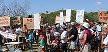
On 23 February 2014 approximately 300 people attended a rally to protest against the Government's plans to "carve up" the G.J. Walter Park as part of its Toondah Harbour redevelopment proposal.[16]
A number of Queensland architects and planners reviewed the scheme at an Urban Design Workshop. The workshop Convenor said the group found the current Toondah scheme "too large, unfeasible and risky".[17] He said the workshop recommended smaller developments across the city linking Raby Bay with Cleveland's CBD and the ferry terminal.[18]
On 4 March 2014 a petition with 1,211 signatures calling for the Government's plans to be withdrawn was tabled in the Queensland Parliament.[19]
On 19 March the Council decided to ask the Queensland Government to make some changes to the plan which include reducing building heights from 15 storeys to 10 and a 400-berth marina at Toondah Harbour instead of 800 berths.[20]
In April 2014, after the consultation period had ended, the Redland City Council released copies of various "expert reports" used to prepare the proposed development scheme.[21]
On 31 May 2014 an approved development scheme was released[22] together with a lengthy report on the 583 submissions received during the consultation period.[23]
Culture and heritage
A number of regionally important cultural facilities are located in Cleveland including:
- Redland Art Gallery
- Redland Museum
- Redland Performing Arts Centre
Cleveland has a number of heritage-listed sites, including:
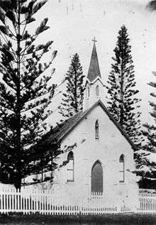
- Cross Street: St Pauls Anglican Church[24]
- Lisa Street: Cleveland Pioneer Cemetery[25]
- 49 North Street: Grand View Hotel[26]
- 1 Passage Street: Old Cleveland Police Station[27]
- 1 Paxton Street: Old Cleveland Court House[28]
- 73 Shore Street East: Fernleigh, early Cleveland buildings whose heritage values include views of Moreton Bay[29]
- 109 Shore Street North: Cleveland Hotel[30]
- 127 Shore Street North: Norfolk Island Pine Trees[31]
- Shore Street North: Cleveland Point Light[32]
Features
Major features of Cleveland include;
- Cleveland Point and the Cleveland Point Light
- G.J. Walter Park, a large public recreation facility located on coastal foreshores north of Toondah Harbour, overlooking Cassim Island
- The Redland Hospital, including the Mater private hospital wing;
- Cleveland Industrial Estate;
- Raby Bay, an area of mangroves and mudflats which has been the subject of canal estate and marina development since 1983;
- Cleveland Showgrounds, home to RedFest, Redlands United FC and many other events;
- The Cleveland Markets, held in Bloomfield Street every Sunday morning;
- Cleveland State School and Cleveland State High School.
- RedFest (formerly known as the Strawberry Festival from 1965–2001)[33]
Transport
Major road access to Cleveland is provided by Finucane Road and Bloomfield Street. Cleveland railway station provides access to regular Queensland Rail City network services to Brisbane via the Cleveland Railway Line. In January 2013, a Queensland Rail suburban train overran the bumper at the end of the line and crashed into the toilet block of the train station.[34] Although initial impression were that the train's brakes had failed, the subsequent inquiry put the blame on the rails being made slippery by a combination of leaves, oil, and rain, possibly caused by a storm a few days earlier.[35]
Demographics
In the 2011 Census the population of Cleveland is 14,414, 52.5% female and 47.5% male.[1] The median/average age of the Cleveland population is 46 years of age, 9 years above the Australian average. 65.9% of people living in Cleveland were born in Australia. The other top responses for country of birth were England 9.9%, New Zealand 6%, South Africa 2.1%, Scotland 1.4%, Germany 0.8%. 89.9% of people speak English as their first language, 0.7% Mandarin, 0.6% German, 0.4% Cantonese, 0.3% Afrikaans, 0.3% Spanish.[1]
References
- 1 2 3 4 Australian Bureau of Statistics (31 October 2012). "Cleveland (Qld)". 2011 Census QuickStats. Retrieved 1 January 2013.
- 1 2 3 The Age. Cleveland. 8 February 2004,
- 1 2 Redland Shire Council, Cleveland. 2006.
- ↑ The Cleveland Point Lighthouse, Lighthouses of Queensland, http://www.lighthouse.net.au/lights/QLD/Cleveland%20Point/Cleveland%20Point.htm, Retrieved 26 February 2014
- 1 2 3 Redland Shire Council, "Latitude 27 - Longitude 153", Boookman Publishers, 2001.
- ↑ Australian Heritage, Search for Cleveland: http://www.heritageaustralia.com.au/search.php?state=QLD®ion=23&view=1095, Retrieved 25 February 2014
- ↑ Queensland Government Gazzette, Volume 46 Published 23 March 1889, Page 1079: http://espace.library.uq.edu.au/eserv/UQ:246872/Queensland_Gov_Gazette_1889_v46/Queensland_Gov_Gazette_1889_v46-1103.jpg?bookpage=true, Retrieved 26 February 2014
- ↑ "Cleveland Parks", Redland City Council, http://www.redland.qld.gov.au/AboutRedlands/History/OurSuburbs/Pages/Cleveland-parks.aspx, Retrieved 17 February 2014
- ↑ Redlands Planning Scheme - Version 6, Part 9, Schedule 4-Heritage Places Register: http://www.redland.qld.gov.au/SiteCollectionDocuments/_Planning_Building/RPS/V4_documents/09.04.pdf, Retrieved on 18 February 2014
- ↑ http://www.redland.qld.gov.au/AboutRedlands/History/OurSuburbs/Pages/Cleveland-timetable.aspx
- 1 2 Joshua Peter Bell, "Moreton Bay And How To Fathom It", Queensland Newspapers, 1984, p 52
- ↑ Department of the Environment, Two species listed as critically endangered under the EPBC Act, 26 May 2015 http://www.environment.gov.au/news/2015/05/26/two-species-listed-critically-endangered-under-epbc-act
- ↑ "Toondah Harbour environmental values ignored by Redland Council", Wildlife Bayside, http://wildlifebayside.wordpress.com/2014/02/09/toondah-harbor-environmental-values-ignored-by-redland-council/, Retrieved 15 February 2014
- ↑ Peter Davie et al, "Wild Guide To Moreton Bay", Queensland Museum, 1998, p 376
- ↑ "Marina plan for Cleveland revamp", Brian Hurst, Bayside Bulletin, 13 January 2014 http://www.baysidebulletin.com.au/story/2017300/marina-plan-for-cleveland-revamp/, Retrieved 15 February 2014
- ↑ "Future of GJ Walter Park defines Toondah debate", Bayside Bulletin, 24 February 2014, http://www.baysidebulletin.com.au/story/2106953/future-of-gj-walter-park-defines-toondah-debate/?cs=213, Retrieved on 25 February 2014
- ↑ Judith Kerr, "Toondah think tank opts for Raby Bay", Bayside Bulletin, 3 March 2014: http://www.baysidebulletin.com.au/story/2123903/toondah-think-tank-opts-for-raby-bay-video/, Retrieved 10 June 2014
- ↑ Judith Kerr, "Crucial council vote on Toondah", Bayside Bulletin, 3 March 2014: http://www.baysidebulletin.com.au/story/2154986/crucial-council-vote-on-toondah/, Retrieved 10 June 2014
- ↑ Judith Kerr, "Parliament hears petition demanding new Toondah plan", Bayside Bulletin, 6 March 2014: http://www.baysidebulletin.com.au/story/2132334/parliament-hears-petition-demanding-new-toondah-plan/?cs=213, Retrieved on 8 March 2014
- ↑ Judith Kerr, "Council limits Toondah building heights, marina", Bayside Bulletin, 19 March 2014: http://www.baysidebulletin.com.au/story/2161339/council-limits-toondah-building-heights-marina/ , Retrieved 3 April 2014
- ↑ Judith Kerr, "Toondah and Weinam Creek expert reports released", Bayside Bulletin, 30 April 2014: http://www.baysidebulletin.com.au/story/2249797/toondah-and-weinam-creek-expert-reports-released/?cs=213, Retrieved 5 May 2014
- ↑ Toondah Harbour Priority Development Area Development Scheme May 2014: http://www.edq.qld.gov.au/resources/plan/pda/development-scheme-toondah-harbour.pdf, Retrieved 1 June 2014
- ↑ Toondah Harbour Priority Development Area Development Scheme Submissions Report, May 2014: http://www.edq.qld.gov.au/resources/plan/pda/submissions-report-toondah-harbour.pdf, Retrieved 1 June 2014
- ↑ "St Pauls Anglican Church (entry 600769)". Queensland Heritage Register. Queensland Heritage Council. Retrieved 12 July 2013.
- ↑ "Cleveland No.1 Cemetery (entry 700008)". Queensland Heritage Register. Queensland Heritage Council. Retrieved 12 July 2013.
- ↑ "Grandview Hotel (entry 600771)". Queensland Heritage Register. Queensland Heritage Council. Retrieved 12 July 2013.
- ↑ "Cleveland Police Station and Court House (former) (entry 601933)". Queensland Heritage Register. Queensland Heritage Council. Retrieved 12 July 2013.
- ↑ "Ye Olde Court House Restaurant (entry 600770)". Queensland Heritage Register. Queensland Heritage Council. Retrieved 12 July 2013.
- ↑ "Fernleigh (entry 601374)". Queensland Heritage Register. Queensland Heritage Council. Retrieved 27 March 2015.
- ↑ "Cleveland Hotel (former) (entry 601130)". Queensland Heritage Register. Queensland Heritage Council. Retrieved 12 July 2013.
- ↑ "Norfolk Island Pine Trees (entry 602181)". Queensland Heritage Register. Queensland Heritage Council. Retrieved 12 July 2013.
- ↑ "Cleveland Lighthouse (former) (entry 600772)". Queensland Heritage Register. Queensland Heritage Council. Retrieved 12 July 2013.
- ↑ "The History of RedFest". Retrieved 3 September 2014.
- ↑ "Train crashes into station on Brisbane's bayside". ABC News. 31 January 2013. Retrieved 18 September 2013.
- ↑ Worthington, Elise (14 March 2013). "Slippery tracks caused Cleveland train crash: ATSB". ABC News. Retrieved 18 September 2013.
External links
| Wikimedia Commons has media related to Cleveland, Queensland. |
- University of Queensland: Queensland Places: Cleveland and Cleveland Shire
- Redlands Tourism
- Redland Museum