Oak Island, Texas
| Oak Island, Texas | |
|---|---|
| Census-designated place | |
 Oak Island | |
| Coordinates: 29°39′42″N 94°41′23″W / 29.66167°N 94.68972°WCoordinates: 29°39′42″N 94°41′23″W / 29.66167°N 94.68972°W | |
| Country | United States |
| State | Texas |
| County | Chambers |
| Area | |
| • Total | 1.20 sq mi (3.11 km2) |
| • Land | 1.20 sq mi (3.11 km2) |
| • Water | 0.0 sq mi (0.0 km2) |
| Elevation | 8 ft (2 m) |
| Population (2010) | |
| • Total | 363 |
| • Density | 302/sq mi (116.7/km2) |
| Time zone | Central (CST) (UTC-6) |
| • Summer (DST) | CDT (UTC-5) |
| Area code(s) | 409 |
| FIPS code | 48-53004[1] |
| GNIS feature ID | 1342993[2] |
Oak Island is an unincorporated community and census-designated place (CDP) in Chambers County, Texas, United States. The population was 363 at the 2010 census.[1]
Geography
Oak Island is located on the eastern shore of Trinity Bay near the geographic center of Chambers County. It is 8 miles (13 km) south of Anahuac, the Chambers County seat.
According to the United States Census Bureau, the Oak Island CDP has a total area of 1.20 square miles (3.11 km2), all of it land.[1]
Hurricane Ike
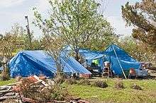
Oak Island residents temporarily living in tents after Hurricane Ike
On September 13, 2008, Hurricane Ike rendered about 90% of the community's homes uninhabitable.[3]
Education
Anahuac Independent School District operates schools in the area.
References
- 1 2 3 "Geographic Identifiers: 2010 Census Summary File 1 (G001): Oak Island CDP, Texas". U.S. Census Bureau, American Factfinder. Retrieved July 27, 2015.
- ↑ U.S. Geological Survey Geographic Names Information System: Oak Island, Texas
- ↑ Shropshire, Corilyn. "Oak Island residents still living in hurricane disaster mode", Houston Chronicle, 2008-11-07, retrieved 2008-11-07
- Oak Island, Texas from the Handbook of Texas Online
External links
Municipalities and communities of Chambers County, Texas, United States | ||
|---|---|---|
| Cities | 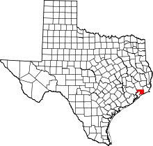 | |
| CDPs | ||
| Other unincorporated communities | ||
| Footnotes | ‡This populated place also has portions in an adjacent county or counties
±water surface only; land in adjacent county | |
This article is issued from Wikipedia - version of the 7/28/2015. The text is available under the Creative Commons Attribution/Share Alike but additional terms may apply for the media files.