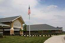
O'Fallon, Illinois
| O'Fallon, Illinois | |||
| City | |||
 | |||
|
|||
| Country | United States | ||
|---|---|---|---|
| State | Illinois | ||
| County | St. Clair | ||
| Township | O'Fallon | ||
| Coordinates | 38°35′46″N 89°54′56″W / 38.59611°N 89.91551°WCoordinates: 38°35′46″N 89°54′56″W / 38.59611°N 89.91551°W | ||
| Area | 14.48 sq mi (38 km2) | ||
| - land | 14.35 sq mi (37 km2) | ||
| - water | 0.12 sq mi (0 km2) | ||
| Population | 28,281 (2010) | ||
| Density | 1,970/sq mi (761/km2) | ||
| Mayor | Gary L. Graham | ||
| Timezone | CST (UTC-6) | ||
| - summer (DST) | CDT (UTC-5) | ||
| Postal code | 62269 | ||
| Area code | 618 | ||
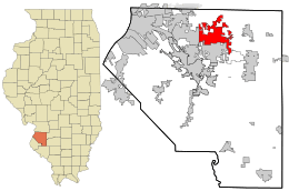 Location in St. Clair County and the state of Illinois. | |||
.svg.png) Location of Illinois in the United States | |||
| Wikimedia Commons: O'Fallon, Illinois | |||
| Website: www.ofallon.org | |||

O'Fallon is a city in St. Clair County, Illinois, United States, and one of the fastest-growing communities in the Metropolitan St. Louis area.[1] The 2010 census listed the city's population at 28,281. The city is the third largest city in the Metro-East region and Southern Illinois. Due to its close proximity to Scott Air Force Base, the population receives a boost from military and federal civilian personnel, defense contractors, and military retirees.
The city center is located approximately two miles east of the intersection of Interstate 64 and U.S. Route 50.
Like its namesake in St. Charles County, Missouri, O'Fallon is part of the St. Louis Metropolitan Statistical Area. This makes O'Fallon (along with the two Troys in Illinois and Missouri) one of the few pairs of like-named municipalities to be part of the same MSA.
History
Founded in 1854, O'Fallon's namesake comes from Colonel John O'Fallon who was a wealthy gentleman from St. Louis. In downtown O'Fallon, a Baltimore and Ohio Railroad railroad depot was built, which helped put O'Fallon on the map. City lots were platted and sold at a public auction on May 18, 1854. A post office was established the following year and the city began attracting German settlers looking for fertile farming land. On January 27, 1874, O'Fallon was incorporated as a village. On March 14, 1905, the citizens voted for a change to the city form of government. Since its founding, O'Fallon has gained population every year except 1930, when the census showed a net loss of six residents.
Growth in O'Fallon has accelerated since the 1980s. Following the expansion of Interstate 64, the 1990s saw a building boom with the construction of several now-established subdivisions including Thornbury Hills, Nolin Creek Estates, Fairwood Hills, Deer Creek, Forest Hills, and the completion of Fairwood East. O'Fallon Township High School's main campus at 600 South Smiley Street has undergone numerous additions over the past decades to ease overcrowding, including the creation of the separate 9th Grade Milburn Campus. A new city hall was completed in 1996. More than 50 percent of O'Fallon's housing is less than 15 years old.[2]
Events
Annual events
- City Hall's event calendar
- May - Memorial Day To Honor Those Who Gave their lives in service of the nation (O'Fallon Veterans Monument)
- August – Homecoming
- September – Arts Festival
- November – Craft Fair; Veterans Day Celebration at O'Fallon Veterans Monument
Parks and recreation
.jpg)
- Family Sports Park
- Hesse Park
- Katy Cavin's Community Center
- O'Fallon Community Park
- O'Fallon Memorial Pool
- Rock Springs Nature Park
- Nature center
- Jogging/cycling paths
- Nature trails
- Natural prairie
- Dog Park
- St. Clair Recreation Complex
- St. Ellen Mine Park
- Thoman Park
- Veteran's Monument
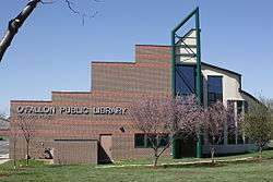
- O'Fallon Public Library
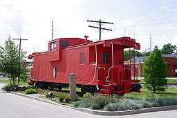
Registered historic places
Schools
- O'Fallon Community Consolidated School District #90
- O'Fallon Central School District #104
- O'Fallon Township High School District #203
- Private schools
Geography
O'Fallon is located at 38°35′N 89°54′W / 38.583°N 89.900°W (38.591549, −89.912000).[3] O'Fallon is:
- 5 miles (8 km) from Scott Air Force Base
- 7 miles (11.5 km) from Lindenwood University – Belleville
- 10 miles (16 km) from McKendree University
- and 17 miles (27 km) from St. Louis, Missouri
According to the 2010 census, the city has a total area of 14.48 square miles (37.5 km2), of which 14.35 square miles (37.2 km2) (or 99.10%) is land and 0.12 square miles (0.31 km2) (or 0.83%) is water.[4]
Demographics
| Historical population | |||
|---|---|---|---|
| Census | Pop. | %± | |
| 1870 | 1,117 | — | |
| 1880 | 921 | −17.5% | |
| 1890 | 865 | −6.1% | |
| 1900 | 1,267 | 46.5% | |
| 1910 | 2,018 | 59.3% | |
| 1920 | 2,379 | 17.9% | |
| 1930 | 2,373 | −0.3% | |
| 1940 | 2,407 | 1.4% | |
| 1950 | 3,022 | 25.6% | |
| 1960 | 4,018 | 33.0% | |
| 1970 | 7,268 | 80.9% | |
| 1980 | 12,173 | 67.5% | |
| 1990 | 16,073 | 32.0% | |
| 2000 | 21,910 | 36.3% | |
| 2010 | 28,281 | 29.1% | |
| Est. 2015 | 29,002 | [5] | 2.5% |
| U.S. Decennial Census[6] 2013 Estimate | |||
As of the census[7] of 2010, there were 28,281 people, 8,310 households, and 6,016 families residing in the city. The population density was 1,970/sq mi (760/km2). There were 8,310 housing units at an average density of 580/sq mi (220/km2). The racial makeup of the city was 82.67% White, 11.99% African American, 0.23% Native American, 2.47% Asian, 0.07% Pacific Islander, 0.79% from other races, and 1.77% from two or more races. Hispanic or Latino of any race were 2.23% of the population.
There were 8,310 households out of which 39.6% had children under the age of 18 living with them, 59.0% were married couples living together, 10.5% had a female householder with no husband present, and 27.6% were non-families. 23.2% of all households were made up of individuals and 7.2% had someone living alone who was 65 years of age or older. The average household size was 2.62 and the average family size was 3.13.
In the city the population was spread out with 28.3% under the age of 18, 8.0% from 18 to 24, 32.2% from 25 to 44, 22.7% from 45 to 64, and 8.9% who were 65 years of age or older. The median age was 35 years. For every 100 females there were 93.2 males. For every 100 females age 18 and over, there were 90.1 males.
The median income for a household in the city was $55,927, and the median income for a family was $66,262. Males had a median income of $46,303 versus $30,158 for females. The per capita income for the city was $248,821. About 4.1% of families and 5.0% of the population were below the poverty line, including 5.0% of those under age 18 and 7.9% of those age 65 or over.
Notable people
- Bob Cryder, professional football player
- Bernie Fuchs, illustrator
- William Holden, Academy Award-winning actor
Gallery
 Homecoming
.jpg) Mayfest Parade
Mayfest Parade O'Fallon Public Library
 City Civil defense siren
References
- ↑ http://www.bernardisecurities.com/html/news_Village_StClair.shtm Archived March 20, 2012, at the Wayback Machine.
- ↑ The Official Site of Southwestern IL Police Consortium
- ↑ "US Gazetteer files: 2010, 2000, and 1990". United States Census Bureau. 2011-02-12. Retrieved 2011-04-23.
- ↑ "2010 Census U.S. Gazetteer Files for Places – Illinois". United States Census. Retrieved 2012-10-13.
- ↑ "Annual Estimates of the Resident Population for Incorporated Places: April 1, 2010 to July 1, 2015". Retrieved July 2, 2016.
- ↑ United States Census Bureau. "Census of Population and Housing". Retrieved May 13, 2015.
- ↑ "American FactFinder". United States Census Bureau. Retrieved 2008-01-31.
External links
| Counties | 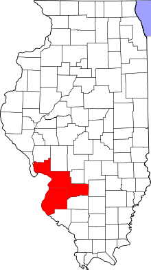 | |
|---|---|---|
| Major Cities (25,000+) | ||
| Cities (5,000-25,000) | ||
| Villages and Towns (1,000-5,000) |
| |
| Interstates in the Metro-East | ||
| Airports/Military Bases | ||
| List of Colleges in the Metro-East | ||
| Sports teams based in the Metro East |
| |
Municipalities and communities of St. Clair County, Illinois, United States | ||
|---|---|---|
| Cities | ||
| Villages | ||
| Townships | ||
| CDPs | ||
| Other unincorporated communities | ||
| Footnotes | ‡This populated place also has portions in an adjacent county or counties | |
| Topics |  | |
|---|---|---|
| Central city | ||
| Largest cities (over 50,000 in 2010) | ||
| Medium-sized cities (over 20,000 in 2010) | ||
| Largest towns and villages (over 10,000 in 2010) |
| |
| Missouri Counties | ||
| Illinois Counties | ||
| Subregions | ||
| Counties |  | |
|---|---|---|
| Mid-sized cities (25,000+) | ||
| Small Cities (10,000-25,000) | ||
| Small Cities (5,000-10,000) | ||
| Interstates | ||
| Airports/Military bases |
| |
| Universities | ||
| Colleges | ||
| Sports teams based in the Southern Illinois | ||