Saline County, Illinois
| Saline County, Illinois | ||
|---|---|---|
 Former Saline County Courthouse in Harrisburg | ||
| ||
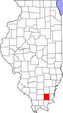 Location in the U.S. state of Illinois | ||
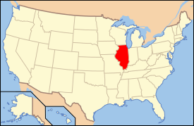 Illinois's location in the U.S. | ||
| Founded | 1847 | |
| Named for | Saline River | |
| Seat | Harrisburg | |
| Largest city | Harrisburg | |
| Area | ||
| • Total | 387 sq mi (1,002 km2) | |
| • Land | 380 sq mi (984 km2) | |
| • Water | 7.0 sq mi (18 km2), 1.8% | |
| Population | ||
| • (2010) | 24,913 | |
| • Density | 66/sq mi (25/km²) | |
| Congressional district | 15th | |
| Time zone | Central: UTC-6/-5 | |
| Website |
www | |

Saline County is a county located in the U.S. state of Illinois. According to the 2010 census, it had a population of 24,913.[1] Its county seat is Harrisburg.[2] It is located in the southern portion of Illinois known locally as "Little Egypt".
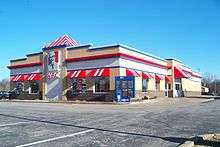
Saline County is home to the largest KFC in the United States. There are three major towns in Saline County connected by U.S. Route 45, and formerly by the now abandoned Cairo and Vincennes/Big Four/New York Central Line, from north to south, Eldorado, Harrisburg, and Carrier Mills.
Saline County is currently the 79th wealthiest county in the state, out of 102.
History
Saline County was formed from Gallatin County in 1847. It is named for the Saline River and the springs from which salt was produced in the early history of Gallatin County.
Saline County was almost named "Moredock County", in honor of John Moredock, who was known the "Indian slayer". A militia officer and a member of the territorial legislature, Moredock had lost his mother and brother in an Indian attack when they were travelling from Pennsylvania to Illinois on the Ohio River in 1786. Young Moredock had been travelling with another group, and he arrived on the scene to find his mother's body terribly mistreated. He not only managed to tracked down and kill every member of the band that did it, but he spent much of his life ambushing and killing Native Americans, whether they were hostile or not. Somewhat controversial because of this, he nevertheless was a popular figure in early Illinois. He died in 1830.
The creation of Saline County was extremely controversial. Illinois originally had a small number of very large counties. As settlement proceeded, new counties were formed out of the original counties as a routine matter. Gallatin County was an early county that was formed in 1812, and quickly split into around fifteen counties, with Gallatin County remaining with what is now Saline County. This persisted for several decades after the era of rapid formation of counties.
Old Shawneetown was the original county seat of Gallatin County. At that time Old Shawneetown was the largest city and commercial center of Illinois. It was, however, located on the eastern edge of the County. In 1826, the county seat was moved to the new village of Equality, near the center of what was then Gallatin County. Old Shawneetown opposed this move, and sought redress by splitting off Saline County, with the aim of moving the County seat of what remained back to Old Shawneetown. Thus the impetus for the formation of Saline County came not from settlers at the fringe of the county, but from the core of the original county.
Saline County was created by a voice vote in the General Assembly in 1847. Completion of the formation of the county, however, involved three acts of the General Assembly, four decisions of the Illinois Supreme Court and two referendums. The controversy came to involve the leading attorneys of Illinois, including Abraham Lincoln.
 Saline County at the time of its creation in 1847
Geography
According to the U.S. Census Bureau, the county has a total area of 387 square miles (1,000 km2), of which 380 square miles (980 km2) is land and 7.0 square miles (18 km2) (1.8%) is water.[3]
The Saline County area is mostly rolling hills throughout gradually rising to the Hills of the Shawnee National Forest. The Saline River flows through the central point of the county in three forks: North, Middle, and South. To the north of Eldorado there are flat lowlands.[4]
Climate and weather
| Harrisburg, Illinois | ||||||||||||||||||||||||||||||||||||||||||||||||||||||||||||
|---|---|---|---|---|---|---|---|---|---|---|---|---|---|---|---|---|---|---|---|---|---|---|---|---|---|---|---|---|---|---|---|---|---|---|---|---|---|---|---|---|---|---|---|---|---|---|---|---|---|---|---|---|---|---|---|---|---|---|---|---|
| Climate chart (explanation) | ||||||||||||||||||||||||||||||||||||||||||||||||||||||||||||
| ||||||||||||||||||||||||||||||||||||||||||||||||||||||||||||
| ||||||||||||||||||||||||||||||||||||||||||||||||||||||||||||
In recent years, average temperatures in the county seat of Harrisburg have ranged from a low of 22 °F (−6 °C) in January to a high of 89 °F (32 °C) in July, although a record low of −23 °F (−31 °C) was recorded in February 1951 and a record high of 113 °F (45 °C) was recorded in July 1936. Average monthly precipitation ranged from 3.04 inches (77 mm) in September to 4.98 inches (126 mm) in May.[5]
Adjacent counties
- Hamilton County (north)
- White County (northeast)
- Gallatin County (east)
- Hardin County (southeast)
- Pope County (south)
- Johnson County (southwest)
- Williamson County (west)
- Franklin County (northwest)
National protected area
- Shawnee National Forest (part)
State protected areas
Transportation
Major highways
Public transportation
Public transportation is provided by the Rides Mass Transit District and Harrisburg Taxi.
Demographics
| Historical population | |||
|---|---|---|---|
| Census | Pop. | %± | |
| 1850 | 5,588 | — | |
| 1860 | 9,331 | 67.0% | |
| 1870 | 12,714 | 36.3% | |
| 1880 | 15,940 | 25.4% | |
| 1890 | 19,342 | 21.3% | |
| 1900 | 21,685 | 12.1% | |
| 1910 | 30,204 | 39.3% | |
| 1920 | 38,353 | 27.0% | |
| 1930 | 37,100 | −3.3% | |
| 1940 | 38,066 | 2.6% | |
| 1950 | 33,420 | −12.2% | |
| 1960 | 26,227 | −21.5% | |
| 1970 | 25,721 | −1.9% | |
| 1980 | 28,448 | 10.6% | |
| 1990 | 26,551 | −6.7% | |
| 2000 | 26,733 | 0.7% | |
| 2010 | 24,913 | −6.8% | |
| Est. 2015 | 24,548 | [6] | −1.5% |
| U.S. Decennial Census[7] 1790-1960[8] 1900-1990[9] 1990-2000[10] 2010-2013[1] | |||
As of the 2010 United States Census, there were 24,913 people, 10,379 households, and 6,631 families residing in the county.[11] The population density was 65.6 inhabitants per square mile (25.3/km2). There were 11,697 housing units at an average density of 30.8 per square mile (11.9/km2).[3] The racial makeup of the county was 93.0% white, 4.0% black or African American, 0.4% Asian, 0.4% American Indian, 0.1% Pacific islander, 0.4% from other races, and 1.8% from two or more races. Those of Hispanic or Latino origin made up 1.4% of the population.[11] In terms of ancestry, 17.8% were Irish, 16.6% were German, 12.9% were American, and 11.1% were English.[12]
Of the 10,379 households, 29.0% had children under the age of 18 living with them, 47.4% were married couples living together, 11.7% had a female householder with no husband present, 36.1% were non-families, and 31.9% of all households were made up of individuals. The average household size was 2.32 and the average family size was 2.89. The median age was 41.7 years.[11]
The median income for a household in the county was $35,644 and the median income for a family was $46,314. Males had a median income of $41,108 versus $28,464 for females. The per capita income for the county was $20,903. About 13.4% of families and 18.4% of the population were below the poverty line, including 26.5% of those under age 18 and 10.4% of those age 65 or over.[13]
Economy
Coal mining makes up the largest percentage of industrial employment in Saline County. The county is home to the Galatia Mine, which by industry standards is the largest underground coal mine in Illinois and currently employs close to 500 workers. The mining and exploration industry feeds other sources of employment such as coal and materials hauling and excavation. Construction fields and services also benefit from Saline County's mining industry.
Other employment in the county is generally made up by the medical, social and state services. Harrisburg is home to the Harrisburg Illinois Youth Center which is operated by Illinois Department of Corrections and holds male juvenile offenders.
The county is served by Southeastern Illinois College, a two-year community college located on state highway 13 about 4 miles east of Harrisburg.
Hospitals serving the county are Harrisburg Medical Center and Ferrell Hospital in Eldorado. Public health services are administered by Egyptian Health Department.
Communities
Cities
Villages
- Carrier Mills (Morrilsville)
- Galatia
- Muddy
- Raleigh
- Stonefort
Unincorporated communities
- Buena Vista
- Cottage Grove
- Delta
- Derby
- Dorris Heights
- Dorrisville
- Eagle
- Francis
- Garden Heights
- Gaskins City
- Harco
- Horseshoe
- Lakeview (Pond Settlement)
- Ledford
- Liberty
- Long Branch
- Mitchellsville
- New Hope
- Newcastle
- Oldtown
- Pankeyville
- Rudement
- Saline
- Somerset
- Texas City
- Tison
- Wasson
- West End
Townships
Saline County is divided into thirteen townships:
See also
References
- 1 2 "State & County QuickFacts". United States Census Bureau. Retrieved July 8, 2014.
- ↑ "Find a County". National Association of Counties. Retrieved 2011-06-07.
- 1 2 "Population, Housing Units, Area, and Density: 2010 - County". United States Census Bureau. Retrieved 2015-07-12.
- ↑ "Geological Survey of Illinois". google.com. Retrieved 14 June 2015.
- 1 2 "Monthly Averages for Harrisburg, Illinois". The Weather Channel. Retrieved 2011-01-27.
- ↑ "County Totals Dataset: Population, Population Change and Estimated Components of Population Change: April 1, 2010 to July 1, 2015". Retrieved July 2, 2016.
- ↑ "U.S. Decennial Census". United States Census Bureau. Retrieved July 8, 2014.
- ↑ "Historical Census Browser". University of Virginia Library. Retrieved July 8, 2014.
- ↑ "Population of Counties by Decennial Census: 1900 to 1990". United States Census Bureau. Retrieved July 8, 2014.
- ↑ "Census 2000 PHC-T-4. Ranking Tables for Counties: 1990 and 2000" (PDF). United States Census Bureau. Retrieved July 8, 2014.
- 1 2 3 "DP-1 Profile of General Population and Housing Characteristics: 2010 Demographic Profile Data". United States Census Bureau. Retrieved 2015-07-12.
- ↑ "DP02 SELECTED SOCIAL CHARACTERISTICS IN THE UNITED STATES – 2006-2010 American Community Survey 5-Year Estimates". United States Census Bureau. Retrieved 2015-07-12.
- ↑ "DP03 SELECTED ECONOMIC CHARACTERISTICS – 2006-2010 American Community Survey 5-Year Estimates". United States Census Bureau. Retrieved 2015-07-12.
- "Tails and Trails of Illinois", Stu Fliege, University of Illinois Press,2002.
- "http://www.iltrails.org/saline/towns_cities.html, © 2000-2001 by Debbie Woolard, Illinois Trails History and Genealogy.
- Gillum Ferguson. 2007. The Perilous Infancy of Saline County, Journal of Illinois History, Vol. 10, p. 49.
External links
 |
Franklin County | Hamilton County | White County | |
| Williamson County | |
Gallatin County | ||
| ||||
| | ||||
| Johnson County | Pope County | Hardin County |
Municipalities and communities of Saline County, Illinois, United States | ||
|---|---|---|
| Cities | ||
| Villages | ||
| Townships | ||
| Unincorporated communities |
| |
| Footnotes | ‡This populated place also has portions in an adjacent county or counties | |
| Counties | 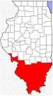 | |
|---|---|---|
| Mid-sized cities (25,000+) | ||
| Small Cities (10,000-25,000) | ||
| Small Cities (5,000-10,000) | ||
| Interstates | ||
| Airports/Military bases |
| |
| Universities | ||
| Colleges | ||
| Sports teams based in the Southern Illinois | ||
Coordinates: 37°45′N 88°32′W / 37.75°N 88.54°W