Norwich, North Dakota
| Norwich | |
|---|---|
| Unincorporated community | |
|
Street in Norwich | |
 Norwich  Norwich Location within the state of North Dakota | |
| Coordinates: 48°14′47″N 100°59′21″W / 48.24639°N 100.98917°WCoordinates: 48°14′47″N 100°59′21″W / 48.24639°N 100.98917°W | |
| Country | United States |
| State | North Dakota |
| County | McHenry |
| Elevation | 1,549 ft (472 m) |
| Time zone | Central (CST) (UTC-6) |
| • Summer (DST) | CDT (UTC-5) |
| ZIP codes | 58768 |
| GNIS feature ID | 1030509 |
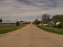
Norwich is an unincorporated community in western McHenry County, North Dakota, United States. It lies along U.S. Route 2 southwest of the city of Towner, the county seat of McHenry County.[1] Its elevation is 1,549 feet (472 m).[2] It is unincorporated, and had a post office with the ZIP code of 58768.[3] Though the post office closed May 4, 1996, the ZIP code is still valid for use.[4]
Norwich was founded in 1901 and named after Norwich, England in an effort to please Great Northern Railway stockholders from England.[5] It was one of several sites along the Great Northern's transcontinental route between Devils Lake and Minot that were named after places in England (the others were Berwick, Leeds, Penn, Rugby, Surrey, Tunbridge, and York).
The community is part of the Minot Micropolitan Statistical Area.
References
- ↑ Rand McNally. The Road Atlas '08. Chicago: Rand McNally, 2008, p. 77.
- ↑ U.S. Geological Survey Geographic Names Information System: Norwich, North Dakota, Geographic Names Information System, 1980-02-13. Accessed 2008-03-31.
- ↑ Zip Code Lookup
- ↑
- ↑ Wick, Douglas A. "Norwich (McHenry County)". North Dakota Place Names. Retrieved 6 May 2011.
Municipalities and communities of McHenry County, North Dakota, United States | ||
|---|---|---|
| Cities | 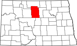 | |
| Townships |
| |
| Unorganized territory |
| |
| Unincorporated communities | ||