Denbigh, North Dakota
| Denbigh, North Dakota | |
|---|---|
| Unincorporated community | |
 Denbigh, North Dakota  Denbigh, North Dakota | |
| Coordinates: 48°18′55″N 100°35′13″W / 48.31528°N 100.58694°WCoordinates: 48°18′55″N 100°35′13″W / 48.31528°N 100.58694°W | |
| Country | United States |
| State | North Dakota |
| County | McHenry |
| Elevation | 1,512 ft (461 m) |
| Time zone | Central (CST) (UTC-6) |
| • Summer (DST) | CDT (UTC-5) |
| Area code(s) | 701 |
| GNIS feature ID | 1028657[1] |
Denbigh, North Dakota is an unincorporated community in McHenry County, North Dakota.[1]
History
A post office called Denbigh was established in 1900, and remained in operation until 1988.[2] The community took its name after Denbigh, in Wales.[3]
It is listed as the nearest community to Norway Lutheran Church and Cemetery, which is actually 10 miles south, and which is listed on the National Register of Historic Places.[4]
References
- 1 2 "Denbigh". Geographic Names Information System. United States Geological Survey.
- ↑ "McHenry County". Jim Forte Postal History. Retrieved 14 February 2015.
- ↑ "100 years of Denbigh history". Mouse River Journal. Jul 4, 2007. p. 2. Retrieved 15 October 2015.
- ↑ National Park Service (2010-07-09). "National Register Information System". National Register of Historic Places. National Park Service.
Municipalities and communities of McHenry County, North Dakota, United States | ||
|---|---|---|
| Cities | 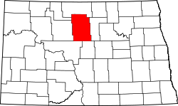 | |
| Townships |
| |
| Unorganized territory |
| |
| Unincorporated communities | ||
This article is issued from Wikipedia - version of the 7/31/2016. The text is available under the Creative Commons Attribution/Share Alike but additional terms may apply for the media files.