North Hero, Vermont
| North Hero, Vermont | |
|---|---|
| Town | |
|
Grand Isle County Courthouse | |
 Location in Grand Isle County and the state of Vermont. | |
 North Hero, Vermont Location in the United States | |
| Coordinates: 44°49′52″N 73°16′25″W / 44.83111°N 73.27361°WCoordinates: 44°49′52″N 73°16′25″W / 44.83111°N 73.27361°W | |
| Country | United States |
| State | Vermont |
| County | Grand Isle |
| Area | |
| • Total | 46.6 sq mi (120.6 km2) |
| • Land | 13.7 sq mi (35.6 km2) |
| • Water | 32.8 sq mi (85.1 km2) |
| Elevation | 105 ft (32 m) |
| Population (2010) | |
| • Total | 803 |
| • Density | 58.9/sq mi (22.8/km2) |
| Time zone | Eastern (EST) (UTC-5) |
| • Summer (DST) | EDT (UTC-4) |
| ZIP code | 05474 |
| Area code(s) | 802 |
| FIPS code | 50-50650[1] |
| GNIS feature ID | 1462164[2] |

North Hero is a town in and the shire town[3] (county seat)[4] of Grand Isle County, Vermont, United States. The population was 803 at the 2010 census.
The town was named for Ethan Allen, an American Revolutionary War patriot and hero.[5]
Government
The North Hero Town Office is located at 6441 US Route 2 and shares a building with the town school.[6]
Geography
According to the United States Census Bureau, the town has a total area of 46.6 square miles (120.6 km2), of which 13.7 square miles (35.6 km2) is land and 32.8 square miles (85.1 km2) (70.50%) is water.
Demographics
| Historical population | |||
|---|---|---|---|
| Census | Pop. | %± | |
| 1790 | 125 | — | |
| 1800 | 324 | 159.2% | |
| 1810 | 552 | 70.4% | |
| 1820 | 503 | −8.9% | |
| 1830 | 638 | 26.8% | |
| 1840 | 716 | 12.2% | |
| 1850 | 730 | 2.0% | |
| 1860 | 594 | −18.6% | |
| 1870 | 601 | 1.2% | |
| 1880 | 637 | 6.0% | |
| 1890 | 550 | −13.7% | |
| 1900 | 712 | 29.5% | |
| 1910 | 496 | −30.3% | |
| 1920 | 494 | −0.4% | |
| 1930 | 485 | −1.8% | |
| 1940 | 442 | −8.9% | |
| 1950 | 407 | −7.9% | |
| 1960 | 328 | −19.4% | |
| 1970 | 364 | 11.0% | |
| 1980 | 442 | 21.4% | |
| 1990 | 502 | 13.6% | |
| 2000 | 810 | 61.4% | |
| 2010 | 803 | −0.9% | |
| Est. 2014 | 805 | [7] | 0.2% |
| U.S. Decennial Census[8] | |||
As of the census[1] of 2000, there were 810 people, 333 households, and 237 families residing in the town. The population density was 58.9 people per square mile (22.8/km2). There were 906 housing units at an average density of 65.9 per square mile (25.5/km2). The racial makeup of the town was 97.53% White, 0.25% African American, 0.25% Native American, 0.37% Pacific Islander, and 1.60% from two or more races. Hispanic or Latino of any race were 0.62% of the population.
There were 333 households out of which 26.7% had children under the age of 18 living with them, 61.0% were married couples living together, 6.3% had a female householder with no husband present, and 28.8% were non-families. 19.5% of all households were made up of individuals and 5.1% had someone living alone who was 65 years of age or older. The average household size was 2.43 and the average family size was 2.79.
In the town the population was spread out with 21.9% under the age of 18, 4.8% from 18 to 24, 26.7% from 25 to 44, 34.3% from 45 to 64, and 12.3% who were 65 years of age or older. The median age was 43 years. For every 100 females there were 101.5 males. For every 100 females age 18 and over, there were 101.0 males.
The median income for a household in the town was $45,577, and the median income for a family was $51,964. Males had a median income of $36,875 versus $31,125 for females. The per capita income for the town was $26,859. About 5.5% of families and 9.0% of the population were below the poverty line, including 12.9% of those under age 18 and 4.0% of those age 65 or over.
References
- 1 2 "American FactFinder". United States Census Bureau. Retrieved 2008-01-31.
- ↑ "US Board on Geographic Names". United States Geological Survey. 2007-10-25. Retrieved 2008-01-31.
- ↑ Title 24, Part I, Chapter 1, §8, Vermont Statutes. Accessed 2007-11-01.
- ↑ "Find a County". National Association of Counties. Retrieved 2011-06-07.
- ↑ Upham, Warren (1920). Minnesota Geographic Names: Their Origin and Historic Significance. Minnesota Historical Society. p. 451.
- ↑ Bianca Slota (2008, July 22), "North Hero Voters Hit the Polls", WCAX News (accessed 8 Oct, 2010)
- ↑ "Annual Estimates of the Resident Population for Incorporated Places: April 1, 2010 to July 1, 2014". Retrieved June 4, 2015.
- ↑ "U.S. Decennial Census". United States Census Bureau. Retrieved May 16, 2015.
External links
- North Hero State Park
- Hero's Welcome General Store, North Hero, VT
- North Hero House, Hotel and Restaurant
Municipalities and communities of Grand Isle County, Vermont, United States | ||
|---|---|---|
| Towns | 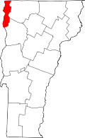 | |
| Village | ||