North Carolina Highway 903
| ||||
|---|---|---|---|---|
|
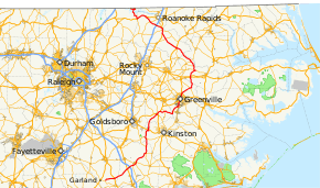
Route of NC 903 in eastern North Carolina highlighted in red | ||||
| Route information | ||||
| Maintained by NCDOT | ||||
| Length: | 200.0 mi[1] (321.9 km) | |||
| Existed: | 1934 – present | |||
| Major junctions | ||||
| South end: |
| |||
|
| ||||
| North end: |
| |||
| Location | ||||
| Counties: | Sampson, Duplin, Lenoir, Greene, Pitt, Martin, Halifax, Warren | |||
| Highway system | ||||
| ||||

North Carolina Highway 903 (NC 903) is a primary state highway in the U.S. state of North Carolina. It serves as predominantly rural highway in the Inner Banks region and arterial road in and around Greenville. The road covers a total of 200 miles (320 km), in a zigzag pattern through the state.
Route description
NC 903 begins at an intersection with NC 411 east of Garland; where it proceeds to first go north, crossing the Black River, and then east through Delway and Magnolia. Northeast of Magnolia, NC 903 connects with Interstate 40 (I-40) at its exit 373 and begin its first concurrency with NC 24 (one of many concurrences along its route). Traveling along the Kenansville Bypass, a rural expressway, it completely bypasses the city of Kenansville. Reverting to a two-lane rural highway and switching to a concurrency with NC 11 and later NC 111, it continues north, crossing the Neuse River, to U.S. Route 70 (US 70) in La Grange. Continuing north, it reaches Snow Hill where it overlaps briefly with NC 58 and with US 13/US 258. Breaking away from the concurrences, it goes east to Maury and then northeast to Winterville, where it meets up with NC 11 again.
As NC 903 enters Greenville, the biggest city along its route, it stays completely on Memorial Drive as various highway routes connect on then off it: NC 43, from Greenville Boulevard to Fifth Street; US 13, joins at Dickinson Avenue; and NC 33, from Greene Street to Belvoir Highway. Halfway through the city, it crosses the Tar River. After passing US 264 in the north Greenville area, NC 903 splits northeasterly from US 13/NC 11 to Stokes and then north to Robersonville which is the first original section of the route. After connecting with US 13 (third and final time) and US 64, NC 903 goes north and merges with NC 125 and travels to Hamilton. Now going in a northwesterly direction, it splits and then reconnects with NC 125 in Scotland Neck, overlapping briefly with US 258 in town. The NC 903/NC 125 concurrency continues to US 301 in Halifax where it finally splits going west towards I-95 and then to US 158, bypassing Roanoke Rapids. Sharing one last concurrency with US 158, it breaks north at Lttleton, going through the Lake Gaston area by first crossing the Roanoke River, travels through the community of Elams, then swings west over Songbird Creek and then finally north into Virginia, where it downgrades to secondary state road 903.
History
NC 903 was established in 1934 as a new primary routing that connected Stokes between NC 11 and US 64; the initial route length was 15.6 miles (25.1 km). In 1938, NC 903 was extended north on new routing from US 64 to NC 125.[2] In 1967 or 1968, NC 903 was extended north, overlapping with NC 125 to Hamilton, then on new primary routing to US 258/NC 125 in Scotland Neck.[3]
Around 1972, NC 903 extended northwest along NC 125 to Halifax, then west on new primary routing to I-95. Between 1976-1978, NC 903 made its first extension south, with an overlap with NC 11 through Greenville and Winterville, then replaced NC 91 south to US 70 in La Grange.[4]
Between 1980-1982, NC 903 was extended west, from I-95, on new primary routing to US 158; it then made its final north extension, between 1984-1990, by overlapping US 158 to Littleton and then through the Lake Gaston area to the Virginia state line, south of Ebony. Also during the late 1980s, NC 903 was extended south on new routing from LaGrange to Albertson, then share concurrences with NC 111 and NC 11 to Kenansville, and again new new primary routing connecting I-40 and to end at US 117 in Magnolia.[5]
In 1994 or 1995, NC 903 was extended southwest to its current southern terminus with NC 411 east of Garland. In 2002, NC 903 was moved onto the Kenansville Bypass.[6]
Junction list
| County | Location | mi[1] | km | Destinations | Notes |
|---|---|---|---|---|---|
| Sampson | | 0.0 | 0.0 | ||
| | 7.1 | 11.4 | |||
| Duplin | Magnolia | 18.9 | 30.4 | ||
| | 21.2 | 34.1 | West end of NC 24 overlap | ||
| | 24.0 | 38.6 | To James Sprunt Community College | ||
| | 26.1 | 42.0 | |||
| | 27.0 | 43.5 | East end of NC 24 overlap | ||
| | 28.1 | 45.2 | South end of NC 11 overlap | ||
| Kornegay | 37.3 | 60.0 | North end of NC 11 and south end of NC 111 overlap | ||
| Albertson | 41.5 | 66.8 | North end of NC 111 overlap | ||
| Lenoir | Husseys Crossroads | 48.6 | 78.2 | ||
| La Grange | 55.5 | 89.3 | |||
| Greene | Snow Hill | 69.4 | 111.7 | South end of NC 58 overlap | |
| 69.7 | 112.2 | South end of US 13 and north end of NC 58 overlap | |||
| | 70.9 | 114.1 | South end of US 258 overlap | ||
| | 73.2 | 117.8 | North end of US 13/US 258 overlap | ||
| Maury | 76.5 | 123.1 | |||
| Pitt | | 83.7 | 134.7 | ||
| Winterville | 90.3 | 145.3 | South end of NC 11 overlap | ||
| Greenville | 93.4 | 150.3 | South end of NC 43 overlap | ||
| 95.4 | 153.5 | South end of US 13 overlap | |||
| 96.4 | 155.1 | North end of NC 43 overlap | |||
| 99.2 | 159.6 | East end of NC 33 overlap | |||
| 99.6 | 160.3 | West end of NC 33 overlap | |||
| 100.0 | 160.9 | ||||
| 100.7 | 162.1 | North end of US 13/NC 11 overlap | |||
| Stokes | 107.2 | 172.5 | |||
| Martin | Robersonville | 116.3 | 187.2 | ||
| | 117.1 | 188.5 | |||
| | 122.9 | 197.8 | South end of NC 125 overlap | ||
| | 124.1 | 199.7 | |||
| Hamilton | 126.8 | 204.1 | North end of NC 125 overlap | ||
| | 130.6 | 210.2 | |||
| Halifax | Scotland Neck | 145.4 | 234.0 | South end of US 258/NC 125 overlap | |
| 145.7 | 234.5 | North end of US 258 overlap | |||
| | 155.9 | 250.9 | |||
| | 160.3 | 258.0 | South end of US 301 overlap | ||
| | 162.5 | 261.5 | East end of NC 561 overlap | ||
| | 162.9 | 262.2 | West end of NC 561 overlap | ||
| Halifax | 163.3 | 262.8 | |||
| 164.0 | 263.9 | North end of US 301 overlap | |||
| | 164.4 | 264.6 | North end of US 125 overlap | ||
| | 169.0 | 272.0 | |||
| | 174.1 | 280.2 | |||
| | 179.6 | 289.0 | East end of US 158 overlap | ||
| Littleton | 186.1 | 299.5 | West end of US 158 overlap | ||
| Warren | | 200.0 | 321.9 | ||
1.000 mi = 1.609 km; 1.000 km = 0.621 mi
| |||||
See also
- North Carolina Bicycle Route 4 - Concurrent with NC 903 from Eaton Ferry Road to River Road near Lake Gaston
- North Carolina Bicycle Route 7 - Concurrent with NC 903 from Jenny Lind Road to Rag Road near La Grange
References
- 1 2 Google (May 19, 2014). "North Carolina Highway 903" (Map). Google Maps. Google. Retrieved May 19, 2014.
- ↑ North Carolina Primary Highway System (PDF) (Map). Cartography by NCDOT. North Carolina Department of Transportation. 1940. Retrieved May 19, 2014.
- ↑ North Carolina Official Highway Map (PDF) (Map). Cartography by NCDOT. North Carolina Department of Transportation. 1970. Retrieved May 19, 2014.
- ↑ North Carolina Official Highway Map (PDF) (Map). Cartography by NCDOT. North Carolina Department of Transportation. 1979. Retrieved May 19, 2014.
- ↑ North Carolina Official Highway Map (PDF) (Map). Cartography by NCDOT. North Carolina Department of Transportation. 1990. Retrieved May 19, 2014.
- ↑ "Route Change (2002-12-16)" (PDF). North Carolina Department of Transportation. December 16, 2002. Retrieved May 19, 2014.
External links
-
 Media related to North Carolina Highway 903 at Wikimedia Commons
 - NCRoads.com: N.C. 903