Neosho Township, Coffey County, Kansas
| Neosho Township | |
|---|---|
| Township | |
 Location in Coffey County | |
| Coordinates: 38°05′00″N 095°44′21″W / 38.08333°N 95.73917°WCoordinates: 38°05′00″N 095°44′21″W / 38.08333°N 95.73917°W | |
| Country | United States |
| State | Kansas |
| County | Coffey |
| Area | |
| • Total | 48.18 sq mi (124.8 km2) |
| • Land | 48.02 sq mi (124.38 km2) |
| • Water | 0.16 sq mi (0.42 km2) 0.34% |
| Elevation | 1,053 ft (321 m) |
| Population (2000) | |
| • Total | 140 |
| • Density | 2.9/sq mi (1.1/km2) |
| GNIS feature ID | 0477863 |
Neosho Township is a township in Coffey County, Kansas, United States. As of the 2000 census, its population was 140.
Geography
Neosho Township covers an area of 48.18 square miles (124.8 km2) and contains no incorporated settlements. According to the USGS, it contains three cemeteries: Big Creek, Crandell and Lorenz Schlichter Memorial.
The streams of Big Creek, Long Creek, North Big Creek, South Big Creek and Turkey Creek run through this township.
Transportation
Neosho Township contains one airport or landing strip, McMullen Airport.
References
External links
Municipalities and communities of Coffey County, Kansas, United States | ||
|---|---|---|
| Cities | 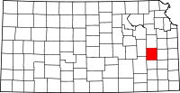 | |
| Unincorporated communities |
| |
| Townships | ||
This article is issued from Wikipedia - version of the 6/26/2016. The text is available under the Creative Commons Attribution/Share Alike but additional terms may apply for the media files.