Gridley, Kansas
| Gridley, Kansas | |
|---|---|
| City | |
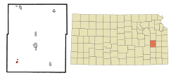 Location within Coffey County and Kansas | |
 KDOT map of Coffey County (legend) | |
| Coordinates: 38°5′58″N 95°53′4″W / 38.09944°N 95.88444°WCoordinates: 38°5′58″N 95°53′4″W / 38.09944°N 95.88444°W | |
| Country | United States |
| State | Kansas |
| County | Coffey |
| Area[1] | |
| • Total | 0.47 sq mi (1.22 km2) |
| • Land | 0.41 sq mi (1.06 km2) |
| • Water | 0.06 sq mi (0.16 km2) |
| Elevation | 1,142 ft (348 m) |
| Population (2010)[2] | |
| • Total | 341 |
| • Estimate (2012[3]) | 337 |
| • Density | 730/sq mi (280/km2) |
| Time zone | Central (CST) (UTC-6) |
| • Summer (DST) | CDT (UTC-5) |
| ZIP code | 66852 |
| Area code | 620 |
| FIPS code | 20-28850 [4] |
| GNIS feature ID | 0478069 [5] |
| Website | gridleyks.org |
Gridley is a city in Coffey County, Kansas, United States. As of the 2010 census, the city population was 341.[6]
History
Gridley was founded in about 1886.[7]
The first post office in Gridley was established on June 23, 1886.[8]
Geography
Gridley is located at 38°5′58″N 95°53′4″W / 38.09944°N 95.88444°W (38.099452, -95.884507).[9] According to the United States Census Bureau, the city has a total area of 0.47 square miles (1.22 km2), of which, 0.41 square miles (1.06 km2) is land and 0.06 square miles (0.16 km2) is water.[1]
Climate
The climate in this area is characterized by hot, humid summers and generally mild to cool winters. According to the Köppen Climate Classification system, Gridley has a humid subtropical climate, abbreviated "Cfa" on climate maps.[10]
Demographics
| Historical population | |||
|---|---|---|---|
| Census | Pop. | %± | |
| 1920 | 321 | — | |
| 1930 | 434 | 35.2% | |
| 1940 | 418 | −3.7% | |
| 1950 | 360 | −13.9% | |
| 1960 | 321 | −10.8% | |
| 1970 | 328 | 2.2% | |
| 1980 | 404 | 23.2% | |
| 1990 | 356 | −11.9% | |
| 2000 | 372 | 4.5% | |
| 2010 | 341 | −8.3% | |
| Est. 2015 | 336 | [11] | −1.5% |
| U.S. Decennial Census | |||
2010 census
As of the census[2] of 2010, there were 341 people, 144 households, and 93 families residing in the city. The population density was 831.7 inhabitants per square mile (321.1/km2). There were 174 housing units at an average density of 424.4 per square mile (163.9/km2). The racial makeup of the city was 97.7% White, 0.9% African American, 0.3% Native American, 0.3% from other races, and 0.9% from two or more races. Hispanic or Latino of any race were 0.3% of the population.
There were 144 households of which 31.3% had children under the age of 18 living with them, 52.8% were married couples living together, 7.6% had a female householder with no husband present, 4.2% had a male householder with no wife present, and 35.4% were non-families. 32.6% of all households were made up of individuals and 17.4% had someone living alone who was 65 years of age or older. The average household size was 2.37 and the average family size was 2.98.
The median age in the city was 37.9 years. 26.7% of residents were under the age of 18; 9.3% were between the ages of 18 and 24; 20.9% were from 25 to 44; 24.7% were from 45 to 64; and 18.5% were 65 years of age or older. The gender makeup of the city was 49.3% male and 50.7% female.
2000 census
As of the census[4] of 2000, there were 372 people, 158 households, and 106 families residing in the city. The population density was 992.9 people per square mile (388.2/km²). There were 168 housing units at an average density of 448.4 per square mile (175.3/km²). The racial makeup of the city was 96.77% White, 0.81% African American, 0.54% Native American, 0.27% Asian, 0.27% from other races, and 1.34% from two or more races. Hispanic or Latino of any race were 0.81% of the population.
There were 158 households out of which 26.6% had children under the age of 18 living with them, 58.9% were married couples living together, 5.1% had a female householder with no husband present, and 32.3% were non-families. 26.6% of all households were made up of individuals and 18.4% had someone living alone who was 65 years of age or older. The average household size was 2.35 and the average family size was 2.86.
In the city the population was spread out with 26.1% under the age of 18, 5.4% from 18 to 24, 22.6% from 25 to 44, 21.8% from 45 to 64, and 24.2% who were 65 years of age or older. The median age was 42 years. For every 100 females there were 100.0 males. For every 100 females age 18 and over, there were 92.3 males.
The median income for a household in the city was $26,346, and the median income for a family was $40,313. Males had a median income of $25,694 versus $19,375 for females. The per capita income for the city was $18,805. About 7.9% of families and 10.7% of the population were below the poverty line, including 3.4% of those under age 18 and 16.1% of those age 65 or over.
References
- 1 2 "US Gazetteer files 2010". United States Census Bureau. Retrieved 2012-07-06.
- 1 2 "American FactFinder". United States Census Bureau. Retrieved 2012-07-06.
- ↑ "Population Estimates". United States Census Bureau. Retrieved 2013-05-29.
- 1 2 "American FactFinder". United States Census Bureau. Retrieved 2008-01-31.
- ↑ "US Board on Geographic Names". United States Geological Survey. 2007-10-25. Retrieved 2008-01-31.
- ↑ "2010 City Population and Housing Occupancy Status". U.S. Census Bureau. Retrieved February 3, 2012.
- ↑ Kansas State Historical Society (1916). Biennial Report of the Board of Directors of the Kansas State Historical Society. Kansas State Printing Plant. p. 165.
- ↑ "Kansas Post Offices, 1828-1961 (archived)". Kansas Historical Society. Archived from the original on October 9, 2013. Retrieved 6 June 2014.
- ↑ "US Gazetteer files: 2010, 2000, and 1990". United States Census Bureau. 2011-02-12. Retrieved 2011-04-23.
- ↑ Climate Summary for Gridley, Kansas
- ↑ "Annual Estimates of the Resident Population for Incorporated Places: April 1, 2010 to July 1, 2015". Retrieved July 2, 2016.
External links
| Wikimedia Commons has media related to Gridley, Kansas. |
- City
- Schools
- USD 245, local school district
- Maps
- Gridley City Map, KDOT
Municipalities and communities of Coffey County, Kansas, United States | ||
|---|---|---|
| Cities | 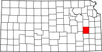 | |
| Unincorporated communities |
| |
| Townships | ||