National Register of Historic Places listings in Suffolk, Virginia

Location of Suffolk in Virginia
This is a list of the National Register of Historic Places listings in Suffolk, Virginia.
This is intended to be a complete list of the properties and districts on the National Register of Historic Places in the independent city of Suffolk, Virginia, United States. The locations of National Register properties and districts for which the latitude and longitude coordinates are included below, may be seen in a Google map.[1]
There are 23 properties and districts listed on the National Register in the city.
- This National Park Service list is complete through NPS recent listings posted November 25, 2016.[2]
Current listings
| [3] | Name on the Register[4] | Image | Date listed[5] | Location | Description |
|---|---|---|---|---|---|
| 1 | Bay Point Farm | |
(#03000571) |
1400 Sleepy Hole Rd. 36°50′42″N 76°31′00″W / 36.845°N 76.516667°W |
|
| 2 | Building at 216 Bank Street | 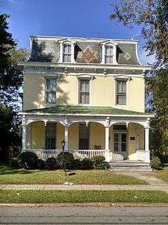 |
(#85002765) |
216 Bank St. 36°43′45″N 76°34′49″W / 36.729167°N 76.580278°W |
|
| 3 | Cedar Hill Cemetery |  |
(#05001584) |
S of E. Constance Rd. 36°44′15″N 76°34′47″W / 36.7375°N 76.579722°W |
|
| 4 | Chuckatuck Historic District | 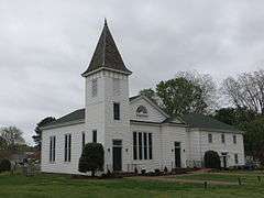 |
(#95000393) |
Jct. of VA 10/32 and VA 125 36°51′40″N 76°34′45″W / 36.861111°N 76.579167°W |
Current settlement dates from 1635 land grant to Richard Bartlett, who built a grist mill at the head of Chuckatuck Creek that operated until 1970. Quaker leader George Fox founded Chuckatuck Meeting in 1672.[6] |
| 5 | Driver Historic District | Upload image | (#95000394) |
Jct. of VA 125 and VA 629 36°49′30″N 76°30′09″W / 36.825°N 76.5025°W |
|
| 6 | Dumpling Island Archeological Site | Upload image | (#98000046) |
Address Restricted |
|
| 7 | East Suffolk Complex |  |
(#03000743) |
231 S. 7th St. 36°43′30″N 76°33′51″W / 36.725°N 76.564167°W |
|
| 8 | Glebe Church | 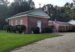 |
(#73002148) |
W of Chesapeake City on VA 337 36°49′29″N 76°29′49″W / 36.824722°N 76.496944°W |
|
| 9 | Godwin-Knight House | 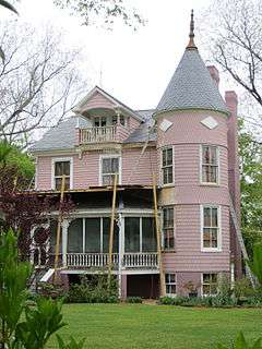 |
(#92001028) |
140 King's Hwy. 36°51′41″N 76°34′40″W / 36.861389°N 76.577778°W |
C.B Godwin home built in 1780 and lived in by Ray and Mildred Knight, sister of Mills E. Godwin, Jr.[6] |
| 10 | Joel E. Harrell Son | Upload image | (#05001580) |
110 Virginia Ham Dr. 36°44′40″N 76°33′31″W / 36.744444°N 76.558611°W |
|
| 11 | Holland Historic District | Upload image | (#95000600) |
Jct. of US 58 with VA 189 and VA 653 36°40′59″N 76°46′32″W / 36.683056°N 76.775556°W |
|
| 12 | Knotts Creek-Belleville Archeological Site | Upload image | (#08000524) |
1000 feet west of intersection of Routes 17 and 658[7] 36°51′53″N 76°26′27″W / 36.864644°N 76.440748°W |
|
| 13 | Mount Sinai Baptist Church | Upload image | (#07000193) |
6100 Holy Neck Rd. 36°38′21″N 76°49′46″W / 36.639167°N 76.829444°W |
|
| 14 | Nansemond County Training School | Upload image | (#04000847) |
9307 Southwestern Blvd. 36°38′22″N 76°48′16″W / 36.639444°N 76.804444°W |
|
| 15 | Phillips Farm | Upload image | (#98001318) |
6353 Godwin Blvd. 36°52′40″N 76°35′03″W / 36.877778°N 76.584167°W |
|
| 16 | Phoenix Bank of Nansemond | 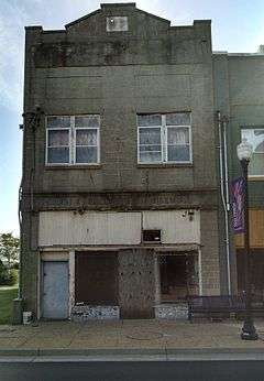 |
(#90002159) |
339 E. Washington St. 36°43′36″N 76°34′43″W / 36.726667°N 76.578611°W |
|
| 17 | Professional Building | 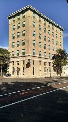 |
(#99001005) |
100 N. Main St. 36°43′41″N 76°35′00″W / 36.728056°N 76.583333°W |
|
| 18 | Riddick House | 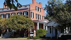 |
(#74002247) |
510 Main St. 36°44′13″N 76°34′57″W / 36.736944°N 76.5825°W |
|
| 19 | St. John's Church | 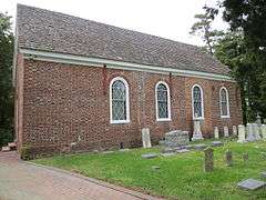 |
(#73002149) |
E of Chuckatuck on VA 125 36°51′25″N 76°33′41″W / 36.856944°N 76.561389°W |
Oldest church in Chuckatuck, est. 1642, present building completed 1756, external dimensions 60 x 30 feet, walls 21 inches thick. Date 1753 appears on south wall along with the initials A.H. and E.H. for Anthony Holladay and his wife Esther, who deeded the site to the parish.[8] |
| 20 | Somerton Historic District | Upload image | (#08001272) |
Arthur Dr., Pittmantown Rd., Boonetown Rd. 36°34′06″N 76°45′03″W / 36.568372°N 76.750911°W |
|
| 21 | Suffolk Historic District | 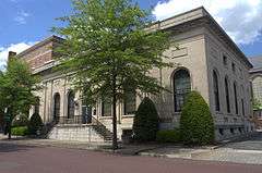 |
(#87000631) |
Roughly bounded by railroad tracks, Hill St., Central Ave., and Holladay, Washington, N. Saratoga, and Pine Sts.; also roughly along N. Main St. from Constance Rd. to the Norfolk Southern railroad tracks; also roughly bounded by the Norfolk Southern railroad tracks, County St., Liberty St., Bank St., Market St., Clay St., and Poplar St.; also Pinner and Central Aves. and W. Washington St. 36°43′49″N 76°34′52″W / 36.730278°N 76.581111°W |
Second, third, and fourth sets of boundaries represent boundary increases of June 10, 1999, September 14, 2002, and December 3, 2004 |
| 22 | West End Historic District | 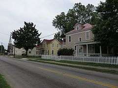 |
(#03001433) |
Roughly bounded by Causey Ave., the Seaboard Coast Line railroad tracks, Pender St., Wellons St., Linden Ave., and other railroad tracks; also roughly bounded by Wellons, Washington, and Smith Sts. 36°43′44″N 76°35′37″W / 36.728889°N 76.593611°W |
Second set of boundaries represents a boundary increase of November 27, 2004 |
| 23 | Whaleyville Historic District | .jpg) |
(#95000392) |
Jct. of US 13 and VA 616 36°35′25″N 76°41′03″W / 36.590278°N 76.684167°W |
See also
| Wikimedia Commons has media related to National Register of Historic Places in Suffolk, Virginia. |
- List of National Historic Landmarks in Virginia
- National Register of Historic Places listings in Virginia
References
- ↑ The latitude and longitude information provided in this table was derived originally from the National Register Information System, which has been found to be fairly accurate for about 99% of listings. For about 1% of NRIS original coordinates, experience has shown that one or both coordinates are typos or otherwise extremely far off; some corrections may have been made. A more subtle problem causes many locations to be off by up to 150 yards, depending on location in the country: most NRIS coordinates were derived from tracing out latitude and longitudes off of USGS topographical quadrant maps created under the North American Datum of 1927, which differs from the current, highly accurate WGS84 GPS system used by most on-line maps. Chicago is about right, but NRIS longitudes in Washington are higher by about 4.5 seconds, and are lower by about 2.0 seconds in Maine. Latitudes differ by about 1.0 second in Florida. Some locations in this table may have been corrected to current GPS standards.
- ↑ "National Register of Historic Places: Weekly List Actions". National Park Service, United States Department of the Interior. Retrieved on November 25, 2016.
- ↑ Numbers represent an ordering by significant words. Various colorings, defined here, differentiate National Historic Landmarks and historic districts from other NRHP buildings, structures, sites or objects.
- ↑ National Park Service (2008-04-24). "National Register Information System". National Register of Historic Places. National Park Service.
- ↑ The eight-digit number below each date is the number assigned to each location in the National Register Information System database, which can be viewed by clicking the number.
- 1 2 Bradshaw, Drexel. "The Village of Chuckatuck in Text". Greater Chuckatuck Historical Foundation. Retrieved 26 April 2013.
- ↑ Turner, E. Randolph, III. National Register of Historic Places Registration Form: Knotts Creek/Belleville Archaeological Site. National Park Service. May 5, 2007.
- ↑ "Chuckatuck Churches". Greater Chuckatuck Historical Foundation. Retrieved 26 April 2013.


This article is issued from Wikipedia - version of the 11/6/2016. The text is available under the Creative Commons Attribution/Share Alike but additional terms may apply for the media files.