National Register of Historic Places listings in St. Charles Parish, Louisiana
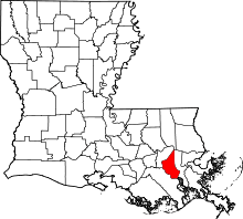
Location of St. Charles Parish in Louisiana
This is a list of the National Register of Historic Places listings in St. Charles Parish, Louisiana.
This is intended to be a complete list of the properties and districts on the National Register of Historic Places in St. Charles Parish, Louisiana, United States. The locations of National Register properties and districts for which the latitude and longitude coordinates are included below, may be seen in a map.[1]
There are 6 properties and districts listed on the National Register in the parish, including 1 National Historic Landmark.
- This National Park Service list is complete through NPS recent listings posted December 16, 2016.[2]
Current listings
| [3] | Name on the Register | Image | Date listed[4] | Location | City or town | Description |
|---|---|---|---|---|---|---|
| 1 | Destrehan Plantation |  |
(#73002132) |
River Rd. (Louisiana Highway 48) 29°56′43″N 90°21′55″W / 29.945278°N 90.365278°W |
Destrehan | Completed in 1790, the site of one of three tribunals which tried and executed slaves after the 1811 German Coast Uprising, the largest slave rebellion in U.S. history; this occurred during the Orleans Territorial period, about eighteen months before Louisiana statehood. The house and grounds have been restored by a nonprofit organization and are open to the public. |
| 2 | Dorvin House |  |
(#90000799) |
Louisiana Highway 18 northwest of Hahnville 29°59′18″N 90°25′15″W / 29.988333°N 90.420833°W |
Hahnville | |
| 3 | Homeplace Plantation House | .jpg) |
(#70000842) |
Louisiana Highway 18, 0.5 miles south of Hahnville 29°58′12″N 90°24′32″W / 29.97°N 90.408889°W |
Hahnville | Built circa 1790, large French Colonial raised cottage. Not open to the public. |
| 4 | Kenner and Kugler Cemeteries Archeological District | Upload image | (#87001762) |
Address Restricted |
Norco | |
| 5 | LaBranche Plantation Dependency |  |
(#84000145) |
River Rd. (Louisiana Highway 48) 29°57′00″N 90°18′58″W / 29.95°N 90.316111°W |
St. Rose | |
| 6 | Ormond Plantation House | 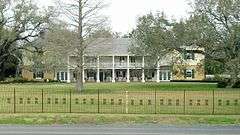 |
(#90001748) |
River Rd. (Louisiana Highway 48) 29°57′15″N 90°23′13″W / 29.954167°N 90.386944°W |
Destrehan |
See also
- List of National Historic Landmarks in Louisiana
- National Register of Historic Places listings in Louisiana
References
- ↑ The latitude and longitude information provided in this table was derived originally from the National Register Information System, which has been found to be fairly accurate for about 99% of listings. For about 1% of NRIS original coordinates, experience has shown that one or both coordinates are typos or otherwise extremely far off; some corrections may have been made. A more subtle problem causes many locations to be off by up to 150 yards, depending on location in the country: most NRIS coordinates were derived from tracing out latitude and longitudes off of USGS topographical quadrant maps created under the North American Datum of 1927, which differs from the current, highly accurate WGS84 GPS system used by most on-line maps. Chicago is about right, but NRIS longitudes in Washington are higher by about 4.5 seconds, and are lower by about 2.0 seconds in Maine. Latitudes differ by about 1.0 second in Florida. Some locations in this table may have been corrected to current GPS standards.
- ↑ "National Register of Historic Places: Weekly List Actions". National Park Service, United States Department of the Interior. Retrieved on December 16, 2016.
- ↑ Numbers represent an ordering by significant words. Various colorings, defined here, differentiate National Historic Landmarks and historic districts from other NRHP buildings, structures, sites or objects.
- ↑ The eight-digit number below each date is the number assigned to each location in the National Register Information System database, which can be viewed by clicking the number.
Municipalities and communities of St. Charles Parish, Louisiana, United States | ||
|---|---|---|
| CDPs | | |
| Other Unincorporated communities | ||
| Footnotes | ‡This populated place also has portions in an adjacent parish or parishes | |
| Topics | |
|---|---|
| Lists by states |
|
| Lists by insular areas | |
| Lists by associated states | |
| Other areas | |
| |
This article is issued from Wikipedia - version of the 4/9/2016. The text is available under the Creative Commons Attribution/Share Alike but additional terms may apply for the media files.